July 11, 2014, 9:00 AM to 3:30 PM
Venue: ODU, IRB2, 4211 Monarch Way, see pdf.
Organizer Contact: Jeffrey Allenby, Chesapeake Conservancy,
e-mail: jallenby at chesapeakeconservancy.org; phone: 443-321-3610.
Objectives:: The details of the challenges for the Hackathon were worked out during an Ideation Meeting.
Hampton Roads is challenged by sea level rise, which causes more frequent flooding. Infrastructure is increasingly submerged, and more data on flooding is needed, both for immediate use and as part of an archive. In order to collect data, sensors and methods need to be economic, simple to deploy, and easy to operate. For example, a low-cost sensor that would send tweets when water level in a location is above or below a certain level would be extremely valuable for many applications.
Goals for the Hackathon could be to develop tools to get more data on floodings that could feed into city planning, and help to validate hydrological model. More information for the public, for example, where to park the car would also serve many, particularly if the information could be distributed through non-web media such as text messages. With a network of sensors for humidity, water level, pollution, and other parameters, an internet of flooding/watery things could be developed.
The deliberations at the meeting resulted in a list of data-related tools and services that could be addressed:
- environmental data collection with sensors
- environmental data collection with crowd sourcing
- crowd sourcing (social data)
- environmental operational real-time services
- response support services
- access to base available knowledge
- what if tools (gaming, simulation, modeling)
These challenges would serve all phases in the risk management cycle:
- preparedness
- early warning
- response
- recovery
Summary of the Wall Chart Notes
Goals:
- Get more data
- amount of flooding
- feed into city planning
- feed into hydrology validation
- additional data to feed predictive & control models & support governmental change
- Norfolk has STORM data collection program
- can't easily update it in real time, so not generally made publicly available
- Google maps traffic
- dissemination -> go to non-internet sources
- SMS to registered users
- “Live” signs that would tell you that the underpass was flooded
- humidity in basements
- water table measurements
- water level during flooding, etc.
High-level objectives:
- vertical evacuation/paths to safety
- tweet/SMS flood to move cars off street w/directions for safety
- Internet of Watery Things
- Water Quality
- Rain garden, flow management, etc.
- sanitary sewer overflow issue w/water table
- bacterial infiltration/localization of source
- industrial run-off
- Planning
- help home purchasers understand risks
- erosion control support
- gamification (“SIMS 2064” or “choose your own water-world adventure”)
- ”Event“ evacuation routes
- gamified
- real-time support
- emergency responders
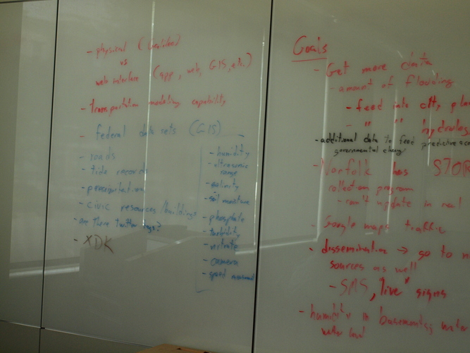
Resource requirements/availability:
- physical (Galileo) vs web interface (app, web, GIS, etc.)
- transportation modeling capability
- federal data sets (GIS)
- roads (mapping)
- tide records
- precipitation
- civic resources/buildings
- twitter tags?
- Intel: XDK
- Intel: Galileo
- quantify # of boards needed
- sensors needed:
- humidity
- ultrasonic range
- salinity
- soil moisture
- phosphate
- turbidity
- nitrate
- camera
- speed measurement
|
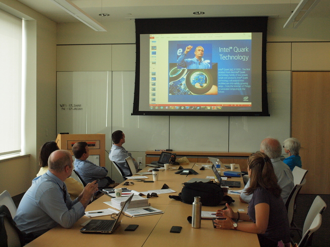
The Ideation session brought together representatives of NGOs, city governments, regional committees, and academia to scope out the challenges for the Hackathon. Here the participants are listening to a presentation on Intel's Galileo Board enabling many citizen science applications.

The Galileo board allows the easy integration of many sensors and external devices making it an excellent board for citizen scientists application.
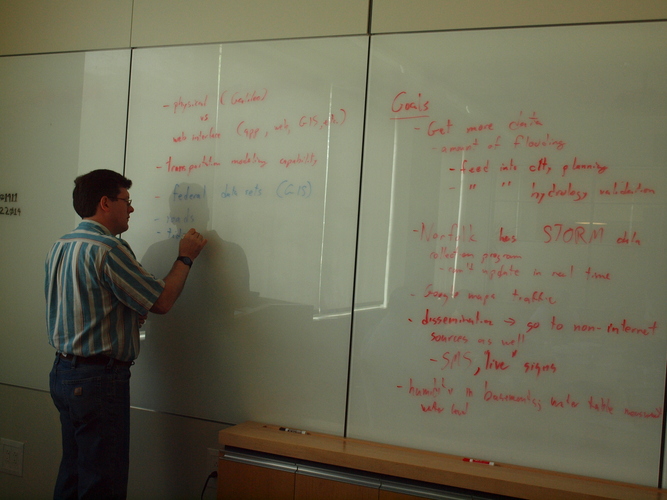
The discourse at the ideation session resulted in the identification of many challenges to decision makers, citizens, and scientists that can be addressed with technology and web-related tools. Here, Matthew Wolf, Georgia Tech is capturing the ideas.
Summary of the outcomes.
Summary of the outcomes.
|