Back to Newsletter Archive ...
Contents
- 2014 Rising Seas Summit
Larry Atkinson Read more ...
- A Review: “Naomi Oreskes: Why we should trust scientists.” Filmed in May 2014 at TEDSalon NY. 19: 14
Michelle Heart Read more ...
- Looking Ahead to Fall 2014 and Beyond
Michelle Covi Read more ...
- Looking Back at the Events in Summer 2014
Michelle Covi Read more ...
- Fall 2014 meeting of the Hampton Roads Sea Level Rise/Flooding Adaptation Forum
Michelle Covi Read more ...
- Meeting the Challenge of Climate Change
Hans-Peter Plag Read more ...
- Ezer and Atkinson publish latest study on coastal flooding in journal “Earth’s Future”
Michelle Covi Read more ...
- Rising to the Challenge: Conference on Sea Level Rise
Michelle Covi Read more ...
2014 Rising Seas Summit
Larry Atkinson
Larry Atkinson was an invitee to the Association of Climate Change Officers (ACCO) “2014 Rising Seas Summit” in New York City 23-25 September. The Rising Seas Summit is organized annually by ACCO. The theme this year was “Developing resources to inform decision making and planning for resilience.” The audience is made up of climate change officers from major international companies and government officials.
The meeting started with a CCO Training Bootcamp on “The Basics of Sea Level Rise and Impacts on Coastal Assets and Infrastructure.” The group included in addition to Atkinson Kelly Burks-Copes from the Army Corps of Engineers, John Englander (author of “High Tide on Main Street”), and Doug Marcy with the NOAA Coastal Hazards. About 30 people from a diverse group of companies, NGOs and governmental agencies attended. Atkinson’s presentation is available here.
Later in the day Atkinson participated a plenary panel. We started with an update by Halidor Thorgeirsson who is with the United Nations Framework Convention on Climate Change (UNFCCC). Then our host, Dan Kreeger, started a Q&A between Atkinson, John Englander and Ben Strauss from Climate Central. Although the topic was “A look at the latest science on sea level rise” it quickly focused on the potential impact of the West Antarctic Ice Sheet and communicating climate change.
Between Bootcamps and plenaries Atkinson had productive conversations with White House CEQ staff, HUD staff and many insurance and engineering companies.
A Review: “Naomi Oreskes: Why we should trust scientists.” Filmed in May 2014 at TEDSalon NY. 19: 14
Michelle Heart
A few weeks ago, after viewing Naomi Oreskes’ May 2014 TED video presentation argument titled “Why we should trust scientists,” the students in my composition class concluded that they could trust Oreskes’ rhetoric because she ‘sounded like someone’s best aunt’ and that she was ‘touchable: someone they could relate and connect to.’
Indeed, in her recent TED presentation, science historian and bestselling author Oreskes skillfully merges the generally distinct identities of a scientist (herself) and her general audience by addressing both as “we” from the beginning. With that connection the impending debate on behalf of the scientists’ credibility becomes all-inclusive, allowing both, the scientist presenting the argument and her public audience, an equal stake to share in its solution.
In addition to the disarming “we” that unifies the stakeholders, Oreskes’ revelatory argument, claiming that we should indeed trust scientists but not for the reasons we think we should, preempts the contrary arguments targeting the naturally shifting trends of scientific methods and purposefully redirects the audience’s focus on the real reason why we must trust the scientists: the sound inductive logic and the communal processes behind the establishing of scientific knowledge. The supporting evidence are presented as series of significant and popularly known turning points in the history of science, correcting a number of common misconceptions including fallacies, along the way.
Oreskes concludes her argument by reemphasizing the ultimately collaborative nature of the solution to the question she has raised at the beginning: that, in order to build trust in scientists, “we” the scientists must learn to communicate well while at the same time “we” the audience must learn to listen well. As both, the scientist and the audience, Oreskes sets the example. As her audience, we may not be able to relate to the science historian Oreskes in full capacity, but the ‘scientist aunt’ Oreskes earns our trust, rather easily.
Looking Ahead to Fall 2014 and Beyond
Michelle Covi
In the Fall and Winter seasons, there will be a number of events organized or supported by MARI that will continue to link MARI with stakeholders in the region and provide more information on climate change, sea level rise, mitigation, and adatation to the stakeholders.
MARI has joined with ODU’s Center for Coastal Physical Oceanography to present a series of seminars from distinguished scientists. This term's seminar is aiming to cover all five main fields of adaptation science, i.e, the hazards, the vulnerability, foresight, decision-making and options. For the remainder of the semester, we have a high caliber line-up of geologist, oceanographers, engineers and other scientists that will be discussing a wide variety of topics. Visit the Seminar Page.
On November 8 and 9, 2014, ODU will host the Chesapeake Bay Hackathon at its Virginia Beach Center. The Hackathon reaches out to programmers and other computer professionals and hobbyists as well as subject matter experts to create tools that allow local governments, planning districts, and conservation organizations to better deal with climate change, sea level rise and flooding. Visit the event page.
Resilient Region Reality Check is an event that Hampton Roads Chapter of the Urban Land Institute is planning with staff from MARI and others in ODU. The objective is to involve a wide cross-section of the Hampton Roads community in the discussion about sea level rise risk and resilience. Look for this event coming in March 2015 or visit the event page.
MARI supports the organization of two high-level international workshops organized by the GEOSS Science and Technology Stakeholder Network of the intergovernmental Group on Earth Observations (GEO. GEO is implementing the Global Earth Observation System of Systems (GEOSS), which aims to provide Earth observation related information for a wide range of applications. The two GEOSS Science and Technology Stakeholder Workshops will take place on March 22-26, 2015 in Norfolk, VA. The first workshop addresses “NAVIGATING SUSTAINABILITY ON A CHANGING PLANET” and the second Workshop focuses on “CONCEPTS, TECHNOLOGIES, SYSTEMS AND USERS OF THE NEXT GEOSS.” For more information, see 3rd Workshop announcement and 4th Workshop announcement.
Looking Back at the Events in Summer 2014
Michelle Covi
From June to September 2014, the Mitigation and Adaptation Research Institute has been organizing and gaining momentum. Much of the activity of the director, Dr. Hans-Peter Plag has been focused on developing the research agenda and writing grant proposals. Summer at MARI involved only a few public events, while the development of the research, education and outreach programs continued.
On September 19, 2014, the Hampton Roads Adaptation Forum brought together scientists, municipal planners and managers, federal/state agency representatives, business people, and NGO representatives to discuss coastal adaptation and preparedness. Over 65 people met at Old Dominion University’s VMASC (Virginia Modeling, Analysis and Simulation Center) facility in Suffolk to discuss flooding and sea level rise assessment tools. Read the newsletter article.
MARI has joined with ODU’s Center for Coastal Physical Oceanography to present a series of seminars from distinguished scientists. This term's seminar is aiming to cover all five main fields of adaptation science, i.e, the hazards, the vulnerability, foresight, decision-making and options. The first three seminars of the semester have featured MARI director, Dr. Hans-Peter Plag, Caroline Massey, from NASA Wallops and Dr. Sarah Cooley, from the Ocean Conservancy. For more information, visit the Seminar Page.
MARI director, Hans-Peter Plag made several public presentations at professional meetings. He participated in the Fall Seminar of the Virginia Association of Surveyors on September 19, 2014, in Newport News in which he presented a lecture on using Continuous GPS for monitoring of land subsidence. See the full program.
Dr. Plag also presented “Leaving the Holocene” at a meeting of the Geological Society Washington (GSW) on September 10, 2014 in Washington D.C.
On September 9, 2014, Hans-Peter Plag joined Skip Stiles of Wetlands Watch in making presentations about the challenge of sea level rise to the Hampton Roads Appraisal Institute (HRAI).
In preparation for the Chesapeake Bay Hackathon, which was postponed to November, — see here - an ideation session to assess the needs of the region and the possible technological projects was held on July 11, 2014 — see the full story here.
Among the most prominent public events of the summer was in June “Rising to the Challenge: A Conference on Sea Level Rise.”This event was sponsored by Senator Tim Kaine at Old Dominion University on June 30, 2014, and it was a discussion of how the federal government and military installation are addressing sea level rise in Hampton Roads, whether those efforts are being coordinated with regional entities and how greater coordination might be used to leverage work being done at all levels and in all sectors. You can read a complete story of the event here.
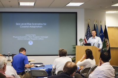
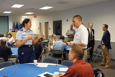
Fall 2014 meeting of the Hampton Roads Sea Level Rise/Flooding Adaptation Forum
Michelle Covi
|
On September 19, 2014, the Hampton Roads Adaptation Forum brought together scientists, municipal planners and managers, federal/state agency representatives, business people, and NGO representatives to discuss coastal adaptation and preparedness. Over 65 people met at Old Dominion University’s VMASC (Virginia Modeling, Analysis and Simulation Center) facility in Suffolk to discuss flooding and sea level rise assessment tools. This was the sixth meeting of its kind since 2012, when Virginia Sea Grant, Old Dominion University (ODU) and the Hampton Roads Planning District Commission (HRPDC) first worked to build a regional network of professionals to share climate adaptation information and lessons learned. The meeting commenced with a brief welcome by HRPDC’s Ben McFarlane and a short report about which sea level rise/flooding viewers registrants to the meeting use and how they are used by Michelle Covi of ODU and Virginia Sea Grant. After introductions from ODU’s Larry Atkinson, the presentations kicked off with a presentation by Adam Parris, program manager from the NOAA Climate Program Office, about the National Climate Assessment. Parris’ focus was on the approach and methods used to develop the sea level rise scenarios for the national assessment that have ultimately been used in many of the sea level rise risk viewers. The national assessment is an inter-agency effort and an attempt to build resilience, not by providing a projection or a prediction of the future, but by developing possible future levels that decision-makers can use in different planning situations. Scenario-based planning was developed by the military to plan for a range of futures and a relative wide range of futures was used to increase the confidence level expressed in the report. The information from the National Climate Assessment is already being used in places like Maryland, where the state convened a panel to re-examine their adaptation plans. The information from the Assessment was also used as part of the Hurricane Sandy recovery in cases where cities, such as New York were interested in rebuilding to increase resilience to future sea levels. In 2013 it was used to write 13 local laws, and was a part of local hazards mitigation plans, levee and beach replenishment designs, factored into Con Ed rate case testimony, and used in plans for restored wetlands and building tidal barriers. Parris said, “Resilience is a process. Resilience is this meeting. It is learning, cooperation, science and exchange. It is using a diversity of approaches including hard and soft, green and gray. You can use the information from the assessment at the local level as a way to engage the federal government to create a smoother path for implementation. “ Tom McNelian spoke briefly at the break about the Dutch Dialogues, a series of talks sponsored by the HRPDC, the Embassy of the Netherlands and McNeilan & Associates. McNeilan explained the process, which includes identifying the stakeholders, meeting them to understand their needs and developing a workshop agenda similar to a planning charrette. He noted that the Dutch are familiar with the challenge of living on low-lying land near the water and eager to help other communities. He said, “ The Dutch view water as the location where environment meets the economy,” a frame of reference that can be very helpful for Hampton Roads. Ben Strauss, Director of the Program on Sea Level Rise for Climate Central presented their Surging Seas viewer, which rolled out its Virginia update earlier in the week. Strauss noted that the Virginia map use LIDAR at 1 meter horizontal resolution, and is an example of a place where they fill in gaps in information that is not available on the NOAA sea level rise viewer. He explained that each of the viewers are complimentary and that Surging Seas has value-added tools that do not exist at the NOAA viewer. While they use national data, they have techniques to localize it and have the ability to create easy and quick reports and summaries. A detailed explanation of the peer-reviewed methodology is available and all of the data is downloadable. Strauss demonstrated the viewer including the map tools to view demographic data and threats to Virginia Beach. He demonstrated the comparison module and explained that Climate Central is beginning a custom analysis service for a small fee that would allow a locality to use their data within the viewer. Gwynn Critchton demonstrated The Nature Conservancy’s Coastal Resilience Tool. The tool is built with locally specific data to solve specific question and problems that a community is facing. The goal of the organization is to bring science, information and action together to reduce risk to coastal hazards. Their tool helps identify nature-based solutions, such as salt marshes, mangroves, sea grass areas, and riparian forests to build resilience to natural hazards. The tool can help support decisions and then measure the effectiveness of the actions taken. Where the tool has been built out, it can be used at multiple scales. It is global in scope, but built with local information and participation. Besides the mapping, there are apps that are configurable, customizable for the specific region. Infographics help users to analyze and understand the data. Other features are split screen, different base maps, SLAMM models, and reporting features that help users to track progress over time. Critchton explained that the Virginia Eastern Shore region will use the tool to design and monitor coastal restoration efforts and look at the future of barrier islands and inlets. They will work with stakeholders to make the tools relevant and applicable to the local community starting in November. Molly Mitchell from the Virginia Institute of Marine Science presented the Comprehensive Coastal Resource Management Tool, which was originally designed to address shoreline best management practices, but now can serve as a sea level rise assessment tool at the local level. The LIDAR data in the tool is the most up to date available in Virginia and as new data becomes available, the portal is updated. The interface is designed for public consumption and decision-making. Sea level rise is part of the county toolbox. Users can look at different management options and compare their shoreline to existing structures, which have all been mapped. Users can find their property, add sea level rise and use a swipe tool to compare past and present. There is also the option of looking at marshes at risk. Future data to be added to the portal includes social vulnerability information, Mitchell said. Brad Ball, leader of the Center for Operations Directorate GIS team at NASA Langley presented the flood impact analysis tool that his group has developed for their campus, the Langley Ari Force Base, the city of Poquosin and Fort Monroe. They found through experience that every storm generated questions to their group, so they designed a portal that was accessible to employees, now behind a firewall, Ball said. The interface has been functional for about 10 years and has allowed users to analyze impacts and threats to infrastructure. There is the ability to switch datums between mean high water, higher high water and other option. They have measured first floor elevations. Other critical elevations, sewage pump stations, steam tunnels and other systems that need to be shut down in a potential flood to protect equipment. They have about 100 web-enabled services and have validated models of storm surge using local tide gauges. The interface is linked to National Weather Service so that real time precipitation and tidal cycles are can be fed into the models. They have used the tool to inform VDOT about changes to bridge and road design, Ball said. They even have information about the number and size of sandbags available in locations to help with storm preparation. Following the presentations a short discussion period allowed forum participants to ask questions of the panel of viewer presenters about the comparative capabilities and availability of data within the tools. They asked “How do we get this all to work together?” While no one could be definitive about where the future of these tools would go, the possibility of bringing them into tools more familiar to public users, such as Google Earth or Google Maps was discussed. |
|
Meeting the Challenge of Climate Change
Hans-Peter Plag
This article has been published previously in CCPO Circulations, Vol. 19, No. 2, Summer 2014.
Climate change and sea-level rise pose unprecedented threats to communities across the world, especially the heavily-populated urban coasts. The changes experienced during the last century are unprecedented during the Holocene, the last geological epoch that started 11,700 years ago. The Holocene was characterized by an exceptionally stable climate, and during the last 7,000 years, and exceptionally stable sea level, allowing civilizations to develop. In the last century, this changed. There is increasing evidence that the changes anticipated for the 21st Century will push the climate outside the range known to civilization and into a phase of much greater variability. This challenges decision-making in all societal sectors, and it requires a new level of preparedness to mitigate the impacts and adapt to the changes.
Vision and MissionMARI's vision is that of thriving coastal communities. In pursuit of this vision, MARI's mission is engaged in mitigation and adaptation research to provide the practice-relevant knowledge needed by coastal communities to handle the challenges, and utilize the opportunities, of climate change and sea level rise. |
Hampton Roads is natural laboratory for climate change and sea level rise. The people in Hampton Roads experience the growing impacts of sea level rise and they are worried. The high rate of local sea level rise, the exposure to extreme weather events, and the complex socio-economic structure are a challenge for a wide range of community stakeholders, including government, military, private sector, and citizens. Recent scientific news about melting ice sheets published in the last months are not reducing these worries. However, in Hampton Roads, the worries result in action, and the communities are growing together to jointly respond to the challenges.
There is an urgent need to develop adaptation science and to produce the practice-relevant knowledge that addresses all these issues. Old Dominion University has established the Mitigation and Adaptation Research Institute (MARI) as a place where societal stakeholders and university experts can work together to create the practice-relevant knowledge that can help ensure thriving coastal communities in the future. These should be communities where people feel safe and look optimistically into the future, where disaster risk is reduced and people are not just waiting for the next disaster to happen, where we have a sound economy and a healthy environment, and where we can enjoy living close to the coast. Making progress towards this vision of thriving coastal communities requires a detailed understanding of the hazards that may occur. Knowing the vulnerabilities of the built and natural environments and the social communities embedded into them helps to assess the risks. Developing a better foresight of what might happen in the future and what impacts our actions might have can inform mitigation and adaptation efforts. We also need to reflect on how we make decisions, and we might have to adapt our underlying value system to the new challenges. Finally, we need to find more options of how we can adapt that are acceptable to our communities. In all of this, MARI aims to support the communities with expertise that ODU and other academic institutions have to offer. In this sense, MARI is a missing piece, the one-stop place to go to for access to mitigation and adaptation knowledge, and for finding partners to create the knowledge, if it does not already exist.
To ensure that the stakeholders get the knowledge they can apply, MARI works closely with them to ensure a co-creation of practice-relevant knowledge and to support them in the use of this knowledge. Continuous input from stakeholders in climate change mitigation and adaptation enables MARI to create the practice-relevant knowledge society needs to find sustainable solutions to the challenge of climate change and sea level rise, which cannot be found without a solid foundation in solution-focused research. Climate change mitigation and adaptation is cross-sectoral and stakeholders relevant to MARI reside in all societal sectors. MARI is developing infrastructure, organizational frameworks, and procedures that ensure a strong and continuous linkage between them and the institute.
Human population has moved from rural into urban areas, and most of the rapidly growing urban areas are in the coastal zone. During the 1933 flood in Hampton Roads only 35,000 people were living in Virginia Beach and Norfolk; today 1 Million people are exposed in the same area to the risk of extreme weather events. Both, on a global scale and in the U.S., an increasing fraction of the population and the most productive infrastructure are in the coastal zone. Accelerating sea level rise is increasing the risk of disasters caused by storms and storm surges, and the frequency and severity of storms is expected to increase and further acerbate this risk. Because of the dependence of humanity on the coastal zone, these disasters threaten food and water security, supply chains, public health, and crucial parts of Earth's life-support system. The coastal zone thus is a frontline for humanity's sustainability. The high economic productivity and importance of the coastal zone rules out a simple retreat to safer areas, and new solutions for living in the coastal zone with a variable sea level need to be found.
MARI focuses on problem-motivated basic and applied research on all aspects of mitigation of climate change and its impacts, as well as adaptation to the changes that cannot be prevented with a view on sustainable development. Implementation of mitigation and adaptation measures require societal decision making, and MARI researches the opportunities and obstacles in decision and policy making and the institutional framework for mitigation and adaptation. The institute aims to develop a wide range of options for mitigation and adaptation. Doing so in an effective manner requires an understanding of the ranges and probabilities of the hazards and the identification of vulnerabilities.
A Stakeholder Driven InstituteMARI creates knowledge with continuous input from the stakeholders through:
|
MARI researches the effect of climate change on sea-level and weather-related hazards and the vulnerability of coastal communities to these hazards and provides risk assessments. The research covers the robustness of the built environment in the urban coast, the robustness and resilience of crucial services such as food, water, communication, transportation, power, and public health, and the resilience of the social fabric in its socio-economic and socio-ecological settings. MARI compares urban coasts in different cultural, social, economic and environmental settings to gain an understanding of the key factors that can support or limit the adaptive capabilities of coastal communities.
MARI facilitates and engages in collaborative, transdisciplinary research that is motivated by real-world problems and focused on the finding of solutions. In its research project, MARI ensures a balance between the traditional academic disciplines and ensure that basic research on transdisciplinary methodology is inherently integrated in the research. MARI works with societal stakeholders to develop options to mitigate and adapt to climate change and sea level rise, and in doing so, MARI also researches methodology for sustained co-design, co-creation, and co-usage of practice-relevant knowledge.
To support, maintain and guide sustainable coastal communities, a work force and societal leadership is needed that can communicate across traditional disciplines and societal sectors. To achieve this, a strong transdisciplinary element in education is needed. MARI engages in the development of transdisciplinary approaches to education related to scientific and societal challenges of climate change, sea level rise, and sustainability in general.
Students are important for the future of our society and engaging them in addressing climate change is crucial for future generations of engaged citizens and a sustainable development. MARI engages students in many different ways in its activities. Linking students to the societal environment is a cornerstone in engaging students.
Creating knowledge is just the first step; in order to affect real change, managing that knowledge effectively and efficiently is crucial. Bringing the knowledge to where it is needed is therefore one of the core activities of MARI, with proactive outreach as the front and end stage of MARI's Knowledge Management process.
MARI is based on the recognition that comprehensive knowledge is the basis for solutions, and that this knowledge can only be derived through interdisciplinary and cross-sectoral collaboration. The discipline-based organization in higher education requires new elements outside this traditional environment that can built transdisciplinary education and research programs linking colleges and departments across boundaries. MARI takes a constructionist approach, which requires a framework bringing together different experts, a wide range of tools, comprehensive databases, and project findings and results for a solution-focused outcome that is practice-relevant. The internal structure of MARI is designed to provide all the functions required to transition from the traditional de-constructionist nature of science providing information to a constructionist approach providing solutions.
The societal, environmental and economic costs of climate change and sea level rise are expected to grow rapidly. MARI aims to enable a wide range of stakeholders to reduce the costs through mitigation where possible and timely adaptation where needed. Importantly, the institute aspires to be a source of new business opportunities and, in cooperation with the business world, helps to generate jobs in the area of mitigation and adaptation.
For the success of MARI, it is important to closely monitor the progress and to evaluate the approaches taken. Evaluation needs to cover all dimensions, including the research carried out and the usefulness of knowledge created, the academic contribution, the economic basis, the linkages to societal stakeholders, and the societal benefits of MARI, including the impact on local businesses and jobs created.
Ezer and Atkinson publish latest study on coastal flooding in journal “Earth’s Future”
Tal Ezer and Larry Atkinson, professors in the Ocean, Earth and Atmospheric Sciences Department and faculty of the Mitigation and Adaptation Research Institute, reported a new association between sea level rise and increasing flooding events on the Atlantic coast. The research was accepted for publication July 16 in the journal Earth's Future of the American Geophysical Union (http://onlinelibrary.wiley.com/doi/10.1002/2014EF000252/full).
Ezer and Atkinson analyzed statistics of sea level from eleven tide gauge stations along the entire U. S. East Coast from Maine to Florida and study multiple factors that lead to flooding events ranging from minor tidal flooding to extreme storm surge events. They found that there was an average increase in annual minor flooding events of about 50 hours from the 1971-1990 to 1991-2013. In some places, like the city of Norfolk, the increase in annual flooding during this period was much larger, from about 40 hours in 1971-1990 to almost 130 hours in 1991-2013. They also found evidence of an increase in flooding events that are not associated with storm surges, instead, they are related to changes in the Gulf Stream: during periods when measurements show weaker than normal Gulf Stream, Norfolk often experience several days of street flooding every high tide.
“We wanted to better understand the relationship between sea level rise and the risk of flood in low lying areas, so that we could improve our ability to be prepared for future flooding,” said Tal Ezer, lead author of the study. “We were surprised how well the changes in the Gulf Stream, as observed off the coast of south Florida many miles away can predict water levels in Norfolk.” We are currently working on research to better understand the mechanism in which changes in ocean currents miles away from shore impact coastal sea level.
While recent studies have identified a “hotspot”for accelerated sea level rise along the east coast of the US north of Cape Hatteras, how the increase affects local areas has not been clear. This research confirms minor, nuisance flooding is directly related to the acceleration in sea level rise and that flooding is increasing in many low-lying areas even with small storms or higher than normal tides. Although increased flooding is seen all along the east coast, the largest acceleration in both sea level and flood duration was observed at Norfolk, VA and Lewes, DE.
“Flooding is only going to get worse in areas such as Norfolk,” says Larry Atkinson, the co-author of the study, “places that only flooded a couple of days a year in the past need to be prepared for more flood days in the future.”
Old Dominion University's Climate Change and Sea Level Rise Initiative (CCSLRI) as well the Center for Coastal Physical Oceanography (CCPO) provided partial support for this study.
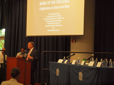
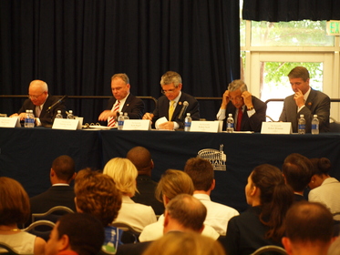
Rising to the Challenge: Conference on Sea Level RiseMichelle Covi On June 30, 2014, Old Dominion University hosted a meeting organized by U. S. Senator Tim Kaine along with U. S. Representatives Scott Rigell, Robert C. “Bobby” Scott, and Rob Whitman along with Norfolk Mayor Paul Fraim and Virginia Beach Mayor Will Sessoms. The meeting, entitled “Rising to the Challenge” was designed to share with the estimated 300 public attendees a discussion of how the federal government and military installation are addressing sea level rise in Hampton Roads, whether those efforts are being coordinated with regional entities and how greater coordination might be used to leverage work being done at all levels and in all sectors. Two panels were convened and the elected officials took turns asking questions of representatives of military, federal, state and local organizations and Old Dominion University. The conference opened with a welcome from Old Dominion University President John Broderick who highlighted efforts at the University, such as the establishment of the Climate Change and Sea Level Rise Initiative in 2010 that has develop the university into a research hub in this area, capitalizing on expertise in modeling and simulation and the development of the Mitigation and Adaptation Research Institute. He noted that Hampton Roads will serve as model for the rest of nation. Senator Kaine, in his opening remarks, spoke about his long dedication to addressing sea level rise and climate change in Virginia. Although different groups of people have been meeting to work on addressing adaptation, this conference is the first with bipartisan representation from elected officials representing the region in the Federal government. He noted that there are significant challenges to this diverse state with a population center only second in the nation for vulnerability to sea level rise. While efforts to adapt are evident at the Navy base and some private homes that are elevated, without action, “someone is going to make the case for going somewhere else.” Senator Kaine admitted that the elected officials may not agree on everything, but that they should find areas of agreement. He said, “ We don‘t need more descriptions of the problem, we need solutions.” He noted that the elected officials in Virginia work well together and that the citizens think the government needs to take action. The task for this conference is to discuss solutions and how elected official can help in facilitating action. Congressman Rigell said that the large turn-out by the public for the event demonstrated the importance of this challenge for the region. He described his experience with flooding in the city and noted that the university is uniquely qualified to address the issue. He acknowledged the efforts take to date and agreed that the Virginia delegation of elected official works well together. Congressmen Scott and Wittman expressed their commitment to working with their colleagues to support efforts to address the challenges of sea level rise. Both looked forward to the opportunity to learn from the panels about the regional efforts to adapt. The focus of the elected officials is on finding areas of agreement so that the region can move forward with solutions. Mayor Fraim introduced the first panel whose members addressed questions of Federal policy activities and needs. The mayor described the challenge of sea level rise, particularly the higher tides which charge the storms so that they are more forceful and destructive. The assets at risk include the second most vulnerable Navy installation in the world. Panel members were introduced as:
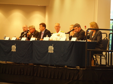
Alice Hill addressed the first question from Senator Kaine about the importance of adaptation to national security by describing how sea level rise puts life and property at risk in the same ways as many other threat to the nation. She said that sea level rise threatens infrastructure and is a mission readiness issue for the military. It is no longer enough to look to the past when we build our infrastructure, we have to look to the future. She listed some of the federal initiatives, such as the one billion dollar competition within HUD for communities hit by recent disaster, green infrastructure grants for the Virginia coastal region, and the federal data initiative. She said that they are learning how the federal government can support a problem that will be addressed at the local level. Admiral Slates was asked by Congressman Rigell for a specific estimate of projected sea level rise and if the Navy had a particular number that it was using in its planning. Slates responded that the Navy uses U.S. Army Corps of Engineers models to plan infrastructure, but they have not used an exact number for their estimates. When considering Norfolk, the issue of land subsidence compounds global sea level rise, so that this is the most vulnerable area for the Navy, he said. They have been taking a prudent approach to factor in climate change resilience- the fuel pier on Craney Island is one example where they built it higher than they would have normally to account to sea level rise. He added that any number that might be used for planning will not be a Navy number and that all the federal entities are working toward developing planning specifics. Skip Stiles of Wetland Watch was asked by Congressman Scott if sea level rise was inevitable or if there is something that can be done to stop it. Mr. Stiles responded that we cannot stop sea level rise and there are a number of issues that add to the rise rate in the region, including subsidence and the contribution of the Gulf Stream slowing, but that people are sick of driving through water and the communities cannot act alone to adapt. Congressman Wittman asked Mr. Steele about the role of the U. S. Army Corps of Engineers in the sea level rise adaptation process. He responded by saying that many people are not aware of that the mission of the Corps extends to flood risk management. People are more familiar with the permitting side of Corps activities, but they also work very closely with cities and other local governments in flood risk management activities as a federal partner. He said that they do not have one number that they use for planning, but they do use three scenario curves that are tied to local conditions. Admiral White was also asked to address the issue of determining sea level rise rates for planning. He responded by noting that there are a range of climate predictions and that it was like a hurricane track in that forecast for the near future have a more narrow range of possible tracks than forecasts for dates farther out. He encouraged the scientific community to get together with engineers to decide when and how infrastructure planning decisions can be made. Mr. Conger added to Admiral White‘s comments that 30 years in the future is the most certain prediction and that is about a foot, but if infrastructure is designed to last longer than 30 years, you need to take greater precaution. Mr. Steele added that the U.S. Army Corp has an on-going North Atlantic Coastal Comprehensive Study that looks at the area from Northern Virginia to Maine. In the study, they are addressing not just risk, but vulnerability, which can be both infrastructure and communities. The focus has shifted from just looking at dollar to looking at vulnerabilities and they currently are talking with Norfolk to address the community needs. He noted that the Corps can work well across cities and regionally. Mayor Fraim explained that he had met with Senators Kaine and Warner and with the Whitehouse to try to find money for sea level rise adaptation projects in Norfolk. Everyone recognizes how important it is for the city to work directly with the Navy to make sure that the workforce can get on and off the base. He said that he is worried about the transportation routes to the base, he is worried about preparedness and wants to know how they can do a better job communicating. Admiral Slates said that he felt that they were doing a good job communicating and that community resilience is a key to the success of the base. He pointed to the Pilot Project/Interagency Task Force as an example of cooperative efforts and partnering. Mayor Sessoms noted that many of the infrastructure project that might help the cities adapt to sea level rise are very expensive. He asked Mr. Steele if there is a regional capitol project that would gives the greatest benefit for the cost. Mr. Steele replied that although they are mandated to take a watershed and regional approach, the problem comes with determining how the projects are funded- who pays for what. They have a history of overcoming this challenge with the Elizabeth River Project. He said that there is no specific regional project identified, but that when they are looking at projects, they look to see if it crosses municipal boundaries and he wondered if there was a way to get the state more engaged in adaptation work. Perhaps the second panel will address this point. Senator Kaine raised the issue of the transportation bill and asked what they could be doing at the federal level to tackle adaptation in the transportation bill. Mr. Conger replied that Part of what you would want to do in any project is take into account the life of the project and projected sea level rise. He gave an example of a Department of Defense directive to reduce building in the 100 year flood plain and moving launch pads at Cape Canaveral rather than recapping them in a flood-prone area. He said that this kind of action is not hard and “there is a lot you can do if you admit there is a risk.” Congressman Rigell asked if there was a specific section of waterfront that is especially impacted and should be targeted for sea level rise risk mitigation. Admiral Slates responded that the region has problems anytime there is a storm and that the Langley base starts to flood before the Naval base at Norfolk. He mentioned some spots with sinkholes and parking problems. One of the major concerns is utilities and improvements in utility resilience would be most welcome. Admiral White responded to a question of the science of sea level rise. He said that planning for flooding is often based on past estimates, but that we need better estimates for the future, better geospatial data. The subsidence portion of regional sea level rise is linear and geospatial information is key. Mr. Steele noted that the comprehensive study from the Corps of Engineers will answer some of the questions currently raised. The study will look at different areas; different adaptation measures, including structural and non-structural solutions; and the costs. Mr. Conger noted that part of the question is how much flooding can you tolerate and making decisions about options based on how the sea level rise will change the geography of the region. Mr. Stiles also noted that there is a large and unknown cost to adaptation. He posed the question “What are the costs of business as usual?” Mr. Wittman asked the panel about how they plan to engage the public on the issue and what the challenges are to public outreach. Ms. Hill responded from the executive perspective, explaining how important it is to let people know the risk of climate change. She pointed to the National Assessment report released in the spring as an example of a document designed to engage the public in the science of climate change. Jim Reddick from the City of Norfolk spoke about the Secure Commonwealth Recurrent Flooding Sub-panel. Mr. Reddick said that they are developing an incident command system and that the group is working to leverage the resources that exist. They will take a unified approach to messaging and that the workgroup that dealt specifically with this observed that there are multiple audiences and that we have to be cautious about being polarizing in the terminology that is used. The first panel closed with a question about how sea level rise will be used to make decisions about navy base closures or realignments. Mr. Conger noted that flooding problems are a kind of encroachment, like many others, but only one piece in a complicated decision process. Mayor Sessoms opened the second part of the program by making some comments about the risk of sea level rise to the Virginia Beach community. He observed that the waterfront portions of the region are of great value to the residents, businesses, industry and military sectors of the community. The municipalities are addressing hurricane preparedness, stormwater needs and other sea level rise affected issues and learning from officials in other coastal states But these are not just local issues, they need coordination with state, federal and regional partners. In Virginia Beach, they just updated the building code to increase resilience; they are developing risk assessments and assisting property owners with repetitive flood losses. He called out the FEMA flood program as one that needs reform and is not serving people in the way that it should. Mr. Sessoms noted that localities cannot address the challenges of adaptation alone and asked the Commonwealth and Federal agencies to provide assistance in the following ways: 1) Recognize the real risk of doing nothing and commit to a stronger leadership role, 2) Identify a responsible partner or agency to coordinate adaptation activities, 3) Assist with data coordination so that assessments of areas of vulnerability can be identified. He then introduced the panel:
Senator Kaine asked Admiral Archizel and Captain Toll to describe the Interagency Pilot Project that is currently being facilitated by Old Dominion University. Admiral Archizel explained that about a year ago President Broderick spoke with him about using an interdisciplinary approach to adaptation in the region. He said ODU is well placed to work on the problem in interdisciplinary and multi-sectorial way. Hampton Roads brings this approach and he believes 50 years from now people will look back and see that it started here. Captain Toll described the pilot project and the individuals who are involved. He noted that this will be a “whole of government”, “whole of community” approach. He spoke about the goals of the pilot project, to help coordinate activities and identify knowledge gaps and funding sources. He noted that business is also part of the approach that they are taking so that it can e a public-private partnership. Congressman Rigell asked Molly Ward to address the issue of coordination of adaptation activities at the state level. Ms. Ward said that there are some concerned about duplicated efforts. The governors is reconstituted the climate commission. There is a call for a one stop shop, but it is hard to say what that might be for the state. It might need to be within the administration, but we need to create that model. Congressman Scott asked the sea level rise adaptation projects might be coordinated on such a way that the Chesapeake Bay might be cleaned up. Randy Keaton said that local governments are working on these issue. They are looking at many different policies and a number of these policies address both sea level rise and water pollution issues. State Senator Locke said that over the past four years the General Assembly has engaged in studies. One was the recurrent flooding study conducted by VIMS and one about disaster preparedness. The housing commission also endorsed moving legislation forward to move ahead with a two year plan to move from studies to policy. Delegate Stolle said that the two resolutions have moved forward. At the state level great work has been done but that has sat on the shelves. They are working on getting action. Mayor Sessoms spoke about economic development in the area. He noted that the economy is very dependent on the military. The key issue is public safety, but there are significant costs involved. Mr. Keaton responded that the question of costs is an important one. The Hampton Roads Planning District Commission has been examining the concept of adaptive management -- how can we plan for 30 years and then change the plan if higher rates of sea level rise happen. Determining the rates is a priority, but also identifying projects. Mayor Fraim also described the local economic situation and noted that red tape needs to be eliminated so that the different entities can work well together. He also said that communications must convey urgency, but not scare people. He is very optimistic about the future. The area is learning how to live with water, but we need to take first steps without creating a sense of panic. Mr. Toll said that there is interest in Norfolk at the Federal level partly because of the local leadership and the citizens that are engaged in this effort. Senator Kaine asked Ms. Ward what could be done on the state level to engage in the whole of community approach to climate adaptation. She replied that there has been a lot of denial and one of the goals of the governments committee, co-chaired by Brian Moran, has been to bring in others and take the whole community approach. Ms. Ward was also asked about Fort Monroe with regards to sea level rise. She responded that the Chesapeake Bay agreement includes climate change. Wetlands mitigation and warmer temperatures are a concern for the administration. Fort Monroe needs to look at the modeling and take that into account. When there is a decision to build a bridge we can take the future water levels into account. Senator Kaine asked the panel about the pros and cons of adding sea level rise to the transportation funding procedure. He expressed some hesitation because he didn‘t want to create hurdles for getting funding. Mr. Keaton responded that they already use sea level rise in transportation planning in the local area. Senator Kaine asked the state elected officials how easy it is for them to talk to their colleagues from other parts of the states about this issue. Delegate Stolle responded that some of the local work is being translated to the state level. The flooding metrics used in the transportation rules apply to the entire state, although they may be primarily applied in Hampton Roads. Senator Locke said that this is not just a Hampton Roads problem. A hurricane can affect many different parts of the state, so solutions developed here can be translated to other areas. To conclude the event, Senator Kaine asked each of the federal elected official to describe their take-aways from the conference. Congressman Whitman said that his main take away is that we have more to do to engage and inform the public on the issue and that they need to find areas of agreement that lead to action points. Congressman Scott said that it is apparent that there is consensus that the area is on the hook short term for one foot of sea level rise in the next 30 year and that regional cooperation is needed to address adaptation. Congressman Rigell said that the meeting was well lead and he was encouraged by the number of people in attendance and especially the young people. He said that there are coordination and communication challenges but that he liked to leave on an optimistic note. Senator Kaine noted that better coordination is needed, but that there are opportunities, such as in the Transportation Bill. He said that we talked about things that are expensive, but since money is being spent anyway, it needs to be spent in a way that tackles the problem. He said that the region has a good track record and he expects that other will want to copy us. He thanked the host and concluded the session. |
The conference was video-taped. To watch the event, click here.
|