Fall 2018: Natural Hazards and Disasters
Natural Hazards and Disasters
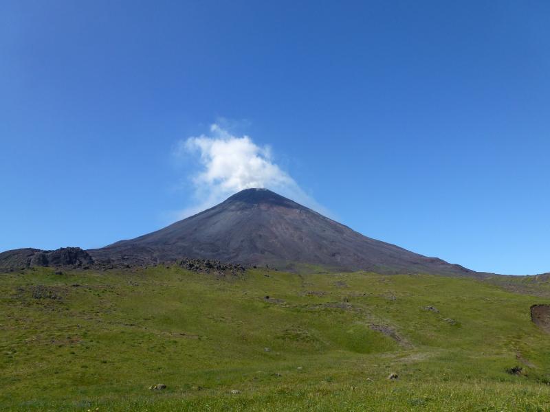
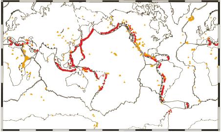
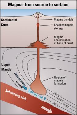
Class 6: VolcanoesVolcanoesVolcanoes are localized places where molten rock and ash mingled with toxic gases and steam erupts onto the surface of the Earth or other planetary bodies. On Earth, active volcanoes are located on divergent or convergent plate boundaries, or above isolated 'hot spots' in the Earth's mantle. Dictionary definitions of 'volcano; generally state that they are cone-shaped mountains with a crater or vent from which magma (molten rock), gases, and hot rocks are ejected. This simple definition fits most people’s idea of a volcano (Fig. 1a), even though many volcanoes are not conical, not all volcanoes are active, and not all eruptive vents in the crust form volcanoes. The majority of visibly active volcanoes are located on convergent plate boundaries (Fig. 1b), such as as the Ring Of Fire around the Pacific Ocean. Chains of submarine volcanoes also comprise Earth’s mid-ocean ridges. Other volcanoes sit above 'hot spots,' areas of localized high heat flow from Earth's mantle that are not necessarily associated with present day plate boundaries.
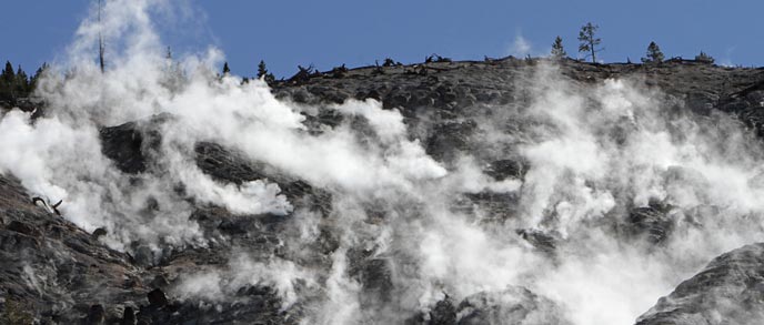
Active vs. DormentActive volcanoes are erupting, show signs of imminent eruption, or have recently erupted. Dormant volcanoes have not erupted in historic times, but that does not mean they are extinct. There is no hard line between an active and a dormant volcano. There are over 500 active volcanoes on Earth that are either currently erupting or have an historical record of eruptions. Their current activity may range from seemingly harmless gaseous emissions and small earthquakes (Fig. 2a) to an explosive eruption of hot rocks, ash, and lava (magma that has reached the surface). If there have been no recent eruptions, but there remains a likelihood of future activity, the volcano is said to be dormant (Fig. 2b). Dormant volcanoes can be among the most deadly, as people may become complacent about the dangers of a new eruption. Volcanoes are only considered extinct when there is no longer any indication of magma moving beneath them and the chance of another eruption is essentially zero.
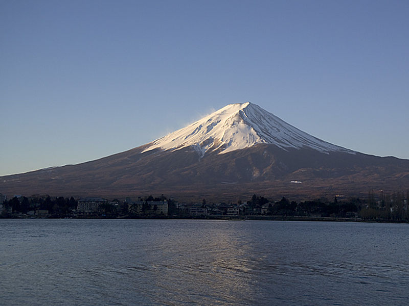
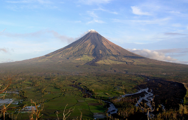
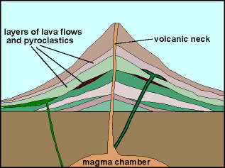
Types of VolcanoesThe composition of a volcano’s lava determines its shape and its behavior. Broad shield volcanoes form relatively quietly from fluid, silica-poor basaltic lava. Silica-rich lava is viscous and builds into conical stratovolcanoes that erupt violently. Lava that forms into rocks of the ocean crust differs chemically and in its physical behavior from lava that erupts from volcanoes above subduction zones. Ocean crust lavas have a basaltic composition, with a high iron and magnesium content and a low silica content, which makes them very fluid. They often form spectacular fountains and lava rivers during eruptions and create broad, low-elevation hills known as shield volcanoes (Fig. 3a). Volcanoes above subduction zones extrude silicarich, iron-poor lavas that are very viscous and can range widely in composition. The layers (strata) of lava and ash build into composite, steep-sided, cone-shaped volcanoes known as stratovolcanoes (Fig. 3b). Although the sticky lava does not flow far from its vent, these volcanoes often erupt huge amounts of volcanic ash in violent explosions.
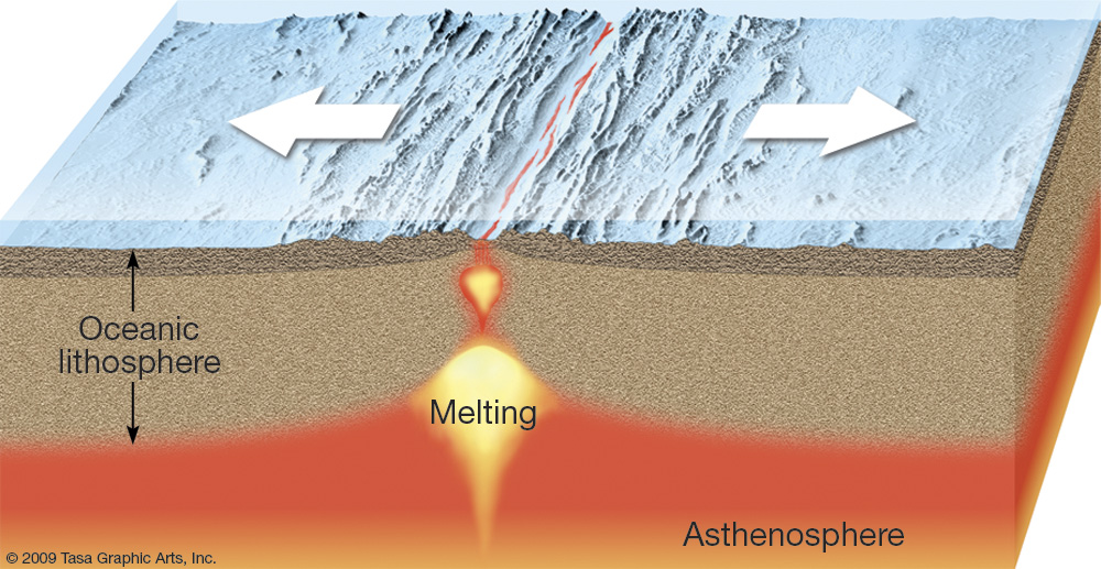
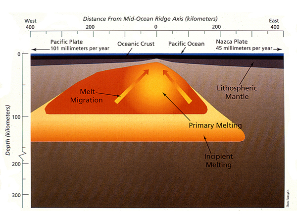
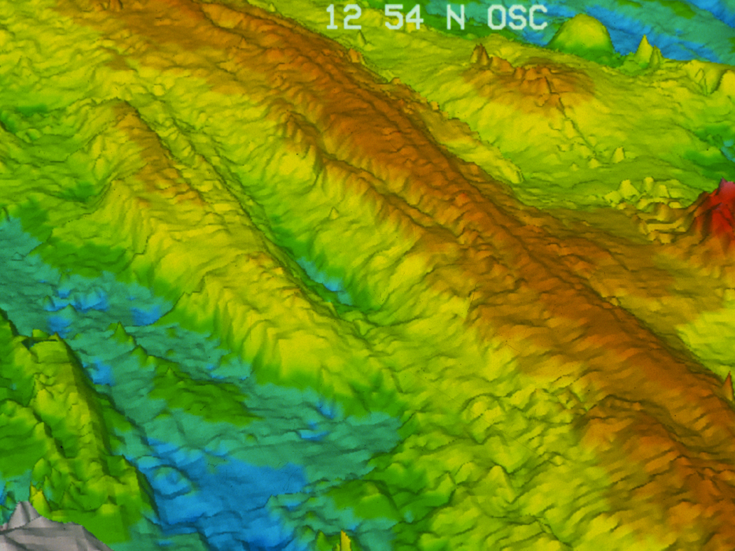
Mid-Ocean Ridge VolcanoesMagma eruptions on divergent plate boundaries are rarely noticeable, yet they have produced extremely long submarine mountain ranges known as mid-ocean ridges. New oceanic crust forms along divergent plate boundaries (Fig. 4a) by the frequent extrusion of basaltic lava from central underwater fissures that separate the two lithospheric plates. Hot magma beneath the plate boundary migrates toward the central fissure (Fig. 4b), slightly elevating the ocean crust’s surface. As the quietly extruded lava solidifies, the resulting basaltic rock forms long, narrow, volcanic ridges (Fig. 4c). The center line of the ridge splits apart with each new eruption, with the result that a symmetrical pattern is created on either side of the fissure as the rocks on one side move gradually away from those on the other side. These linear volcanic ridges link to form a 60,000 km-long, underwater mid-ocean mountain range that includes the Mid-Atlantic Ridge and the East Pacific Rise, among others.
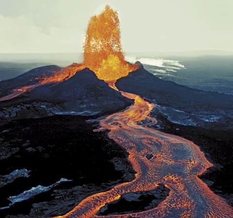
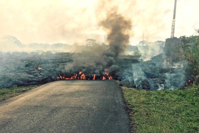
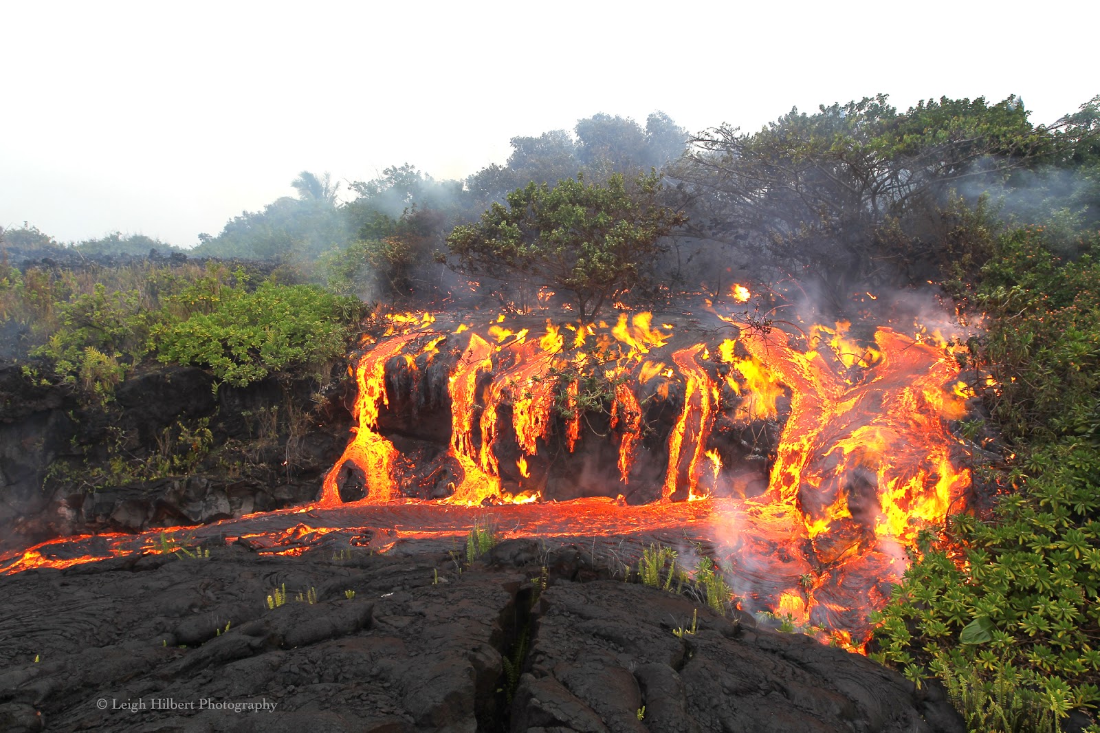
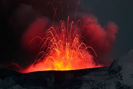
Basaltic Shield VolcanoesBasaltic lava is very fluid and builds broad, lowelevation volcanoes. The lava can travel long distances as lava rivers on surface and through tubes under the solidified surface crust. Basaltic lava has a low viscosity that allows it to flow easily in lava rivers and lobes, gradually building up shield volcanoes. Active shield volcanoes, such as those on Hawaii, erupt frequently and do pose a hazard (Fig. 5a), but usually give warning of an impending eruption through micro-earthquake activity and an increase in gas emissions before the lava erupts. On contact with the atmosphere or water, the surface skin of the lava cools and solidifies into a black basalt rock crust that insulates the still molten lava below. Under the crust, lava continues to flow (Fig. 5b) until it cools, becomes more viscous, and finally stops moving. Lava tubes under the surface (Fig. 5c) act as conduits that feed the front of the flow, keeping the lava moving until they, too, finally cool and solidify.
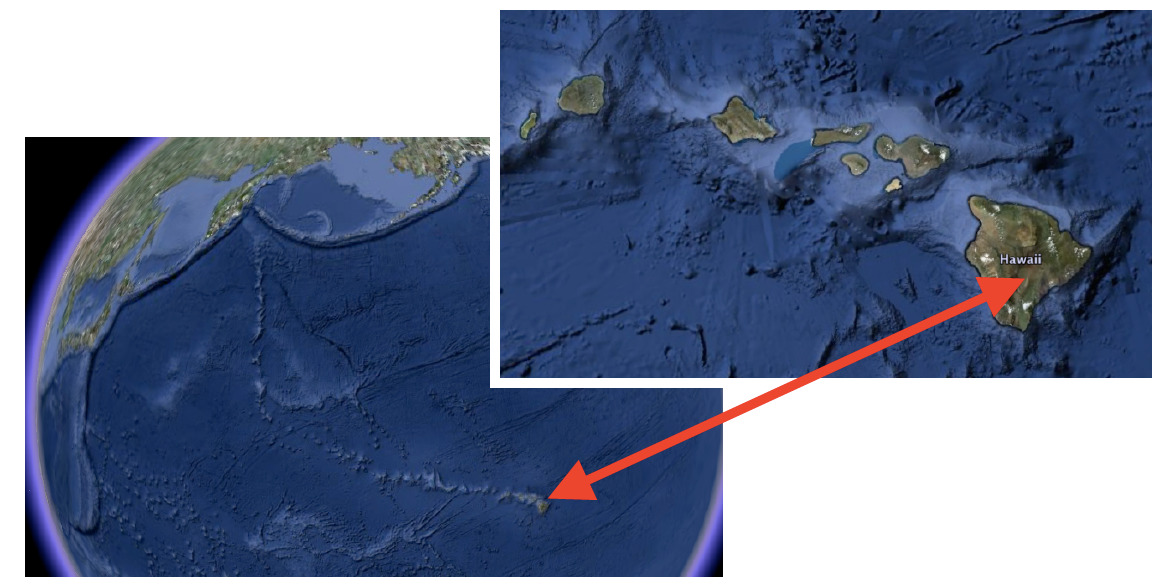
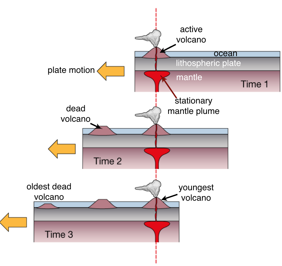
The Hawaiian Island ChainThe Hawaiian Islands formed above a mantle hot spot and are composed of active, dormant, and extinct volcanoes, with the active ones forming the easternmost islands. Although they are in the middle of the Pacific Ocean, the Hawaiian Islands did not form above a divergent plate boundary. The islands are the youngest of a chain of basaltic shield volcanoes and seamounts in the Pacific Ocean that becomes progressively older westward, away from Hawai’i, and extends 5,800 km to Kamchatka, Russia (Fig. 6a). Each of the more than 80 volcanoes in the chain is thought to have formed above the same localized ‘hot spot’ plume of magma which rises from the mantle (Fig. 6b) through the oceanic crust and is currently located beneath Hawai’i. There are currently four active volcanoes on the Hawaiian Islands. A fifth active volcano, Lo’ihi, is growing underwater on the eastern flanks of Kilauea and Mauna Loa. Although its summit is still more than 900 m below sea level, Lo’ihi is poised to become the newest Hawaiian Island.
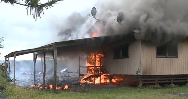
Active Hawaiian VolcanoesThe frequent eruptions from Kilauea and Mauna Loa cause destruction of roads, farmland, and property on the Hawaiian islands. One of the most active volcanoes anywhere in the world is Kilauea, on the island of Hawai’i. More than 60 separate eruptions have been recorded over the past 250 years and there have been eruptions somewhere on or around the volcano non-stop since 1983 (Fig. 7a). Kilauea’s neighboring volcano, Mauna Loa is the world’s largest active volcano. It has erupted 15 times since 1900 although only twice since 1950, in 1975 and 1984, which causes volcanologists to consider it due for another eruption. Nearby Hualalai last erupted in 1801 and is being monitored by geologists in case it shows signs of new activity. Haleakalā (Fig. 7b), on the island of Maui, is also considered active. Its most recent eruption occurred between 200 and 500 years ago and it is also under constant surveillance.
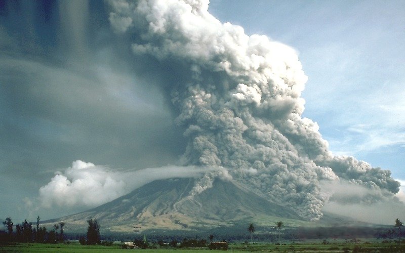
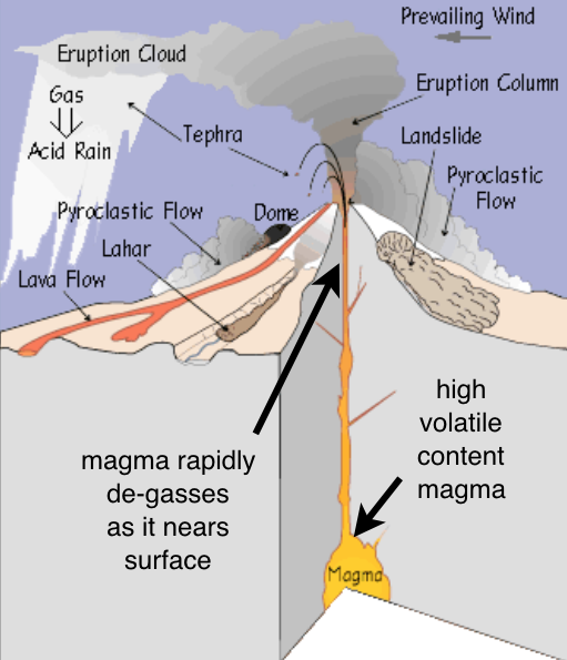
StratovolcanoesStratovolcanoes, also called composite volcanoes, are highly dangerous. They can explosively erupt ash, fast-moving pyroclastic flows, and lava. Volcanoes that form along subduction zones have viscous, silica-rich lava that originates as magma in the mantle above the subducting plate (Fig. V8a). Three of the most common varieties of this type of lava are called rhyolite, dacite, and andesite (after the Andes mountains). These lavas do not flow easily and can clog the volcano’s conduits. Gas becomes trapped in the lava, eventually creating explosive bursts of hot ash, gas, and rock fragments called pyroclastic flows that build a composite stratovolcano (Fig. 8a). The sticky lava that flows from the volcano’s vents cannot travel very far, however pyroclastic flows are fluid and can travel many kilometers. Volcanic ash from stratovolcanic eruptions is often voluminous (Fig. 8b), thickly blanketing broad regions downwind and falling in lesser amounts hundreds or even thousands of kilometers away.
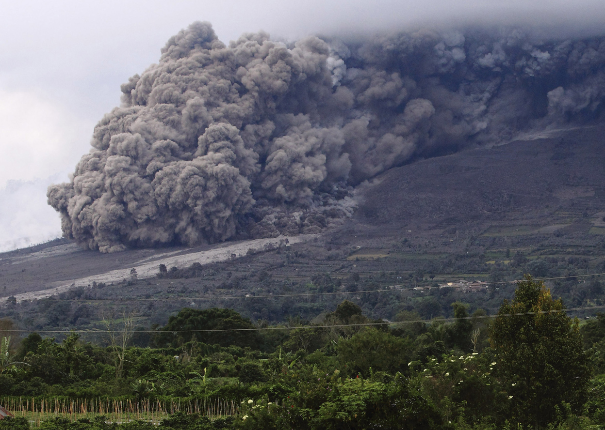
Pyroclastic FlowsPyroclastic flows are highly dangerous, extremely fast-moving avalanches of hot gas, lava, and rock. As sticky, silica-rich magma rises to the surface it reaches a point where the surrounding rock no longer provides enough pressure to keep gases dissolved in the magma. Rapidly degassing magma can generate an explosive outpouring of rock fragments, molten lava globules, pumice (frothy lava), ash, steam, and toxic gases at temperatures of up to 800°C. This outburst becomes a dense, hot avalanche known as a pyroclastic flow (Fig. 9a). Hot gases in the pyroclastic flow at first continue to expand, keeping the solid particles in suspension – a process called fluidization. The dense mixture surges down the volcano’s flank at up to 200m per second, hugging the ground (Fig. 9b) and following valleys (Unzen, Japan, Pyroclastic Flow 2010). Eventually, often after tens of kilometers, the mixture cools, the suspended particles solidify and fuse, and the flow stops.
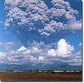
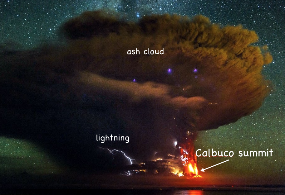
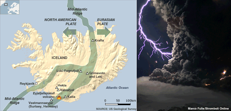
TephraExplosive eruptions produce pulverized lava and rock fragments, called tephra. Large blocks are called volcanic bombs. Fine tephra particles form ash plumes and ash clouds. Explosive expansion of hot gases from volatile-rich magmas pulverizes the rocks around the volcanic vent into fragments, called tephra, and forces them out of the volcano at ballistic speeds (up to 200 m per second). Large blocks, called bombs, land close to the vent (Fig. 10a), but the hot gases carry millimeter-sized and smaller particles, known as ash, in plumes that reach high altitude before spreading to form an ash cloud (Fig. 10b). Lightning bolts are caused by electrically charged wet ash in the cloud (Fig. 10c). The ash is deposited downwind from the volcano, with the thickest deposits nearest the vent. Where an ash plume extends to the upper atmosphere or stratosphere, the particles are kept aloft by high altitude winds and may circle the Earth for months or years, sometimes noticeably dimming sunlight.
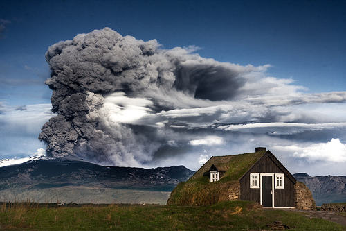
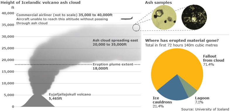
Plumes And AircraftAsh plumes and ash clouds from volcanic eruptions have caused aircraft engine failure. Intersection with a thick ash cloud from Mount Galunggung volcano, near Jakarta, Indonesia, caused all 4 jet engines to fail on British Airways Flight #9 on June 24, 1982 (Fig. 11a). Fortunately, the flight crew were able to glide the airplane to a safe landing. A similar incident occurred on December 15, 1989, when KLM Flight #867 flew through an ash cloud emanating from Alaska’s Mount Redoubt. The flight dropped 4,000 m in 8 minutes before the aircraft’s engines were able to be restarted and the plane safely landed. In April 2010, an ash plume from Iceland's Eyjafjallajökull volcano (Fig. 11b) reached a height of 5,500 m (18,000 ft) before high altitude winds dispersed it into a diffuse ash cloud over western Europe (Fig. 11c). Although this was not an especially large volume eruption, commercial air traffic was disrupted throughout Europe for several weeks.
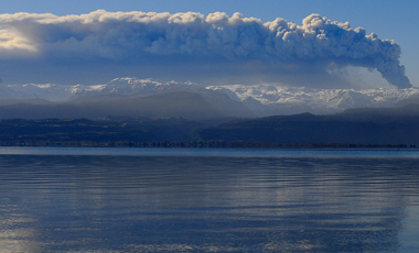
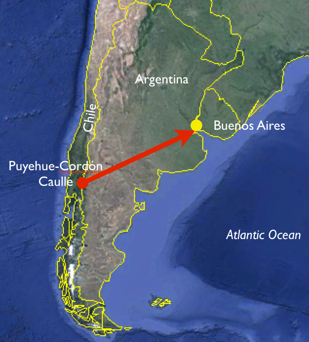
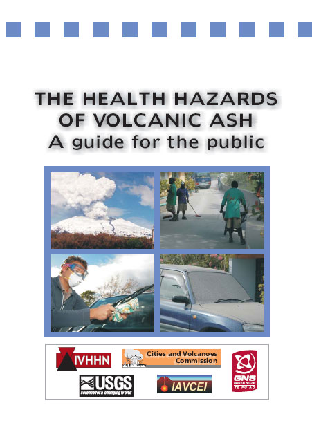
Volcanic Ash And HealthThe fertile soil that volcanic ash and rock produce is good for farming, but living downwind from an active volcano carries a significant health risk. Volcanic ash is rich in minerals and produces very high quality soil, which encourages agricultural activity even right onto the slopes of active volcanoes. If there is a pyroclastic flow, fatal burns and asphyxiation are inevitable. But even cooled ash falls carry health risks to both humans and livestock. Chile’s Puyehue-Cordón Caulle volcano produced an ash plume in 2011 that lasted for 9 months and circled the southern hemisphere. Ash fall extended as far as Buenos Aires, Argentina (Fig. 12a). In addition to disrupting air traffic, the ash killed hundreds of thousands of sheep, goats and cattle in Chile and Argentina from a combination of starvation and ingestion of toxic amounts of fluoride. Angular ash particles can affect human respiratory systems if inhaled for more than a few days. Face masks are advised for those who have to clear away volcanic ash from their homes (Fig. 12b).
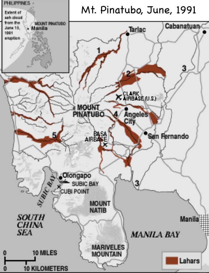
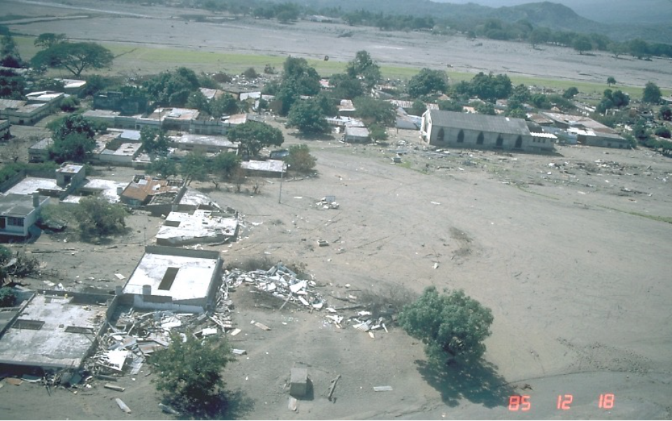
LaharsRivers of tephra and water slurry, called lahars, are a danger to those who live near volcanoes. Stratovolcanoes with snowcaps, crater lakes, or in areas of heavy rains, are especially dangerous during an eruption. The water mixes with tephra to form a mud- and rock-rich slurry, called a lahar, that forms a fast-moving flow of debris down the volcano’s flanks and down-valley (Fig. 13a). Although lahars most often occur during an eruption, heavy rain can trigger them at any time. The eruption of Nevada del Ruiz in Colombia, in 1985, created one of the worst lahar disasters of recent decades. Lahars flowed for over 100 km down the valley of Río Lagunillas, engulfing the town of Armero in up to 5 m of volcanic mud and rock (Fig. 13b). More than 23,000 people were killed and more than 5,000 homes were destroyed. For those who live in valleys that radiate from active volcanoes, the risk of a lahar may be mitigated to some extent by levees, although these may be overrun by extremely large lahar flows.
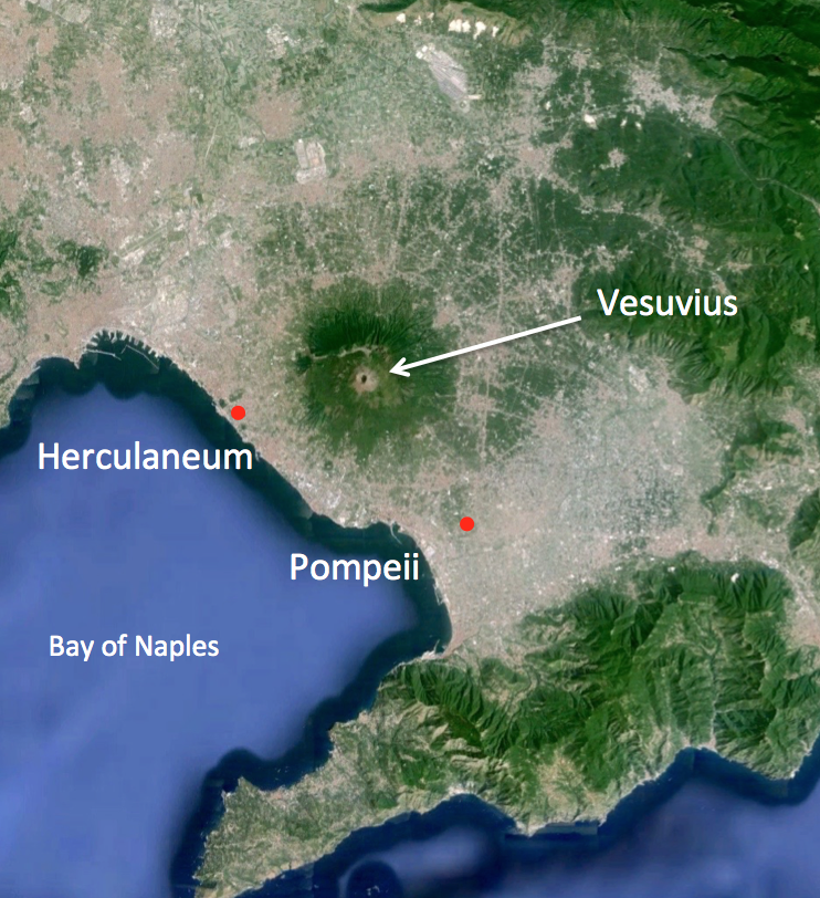
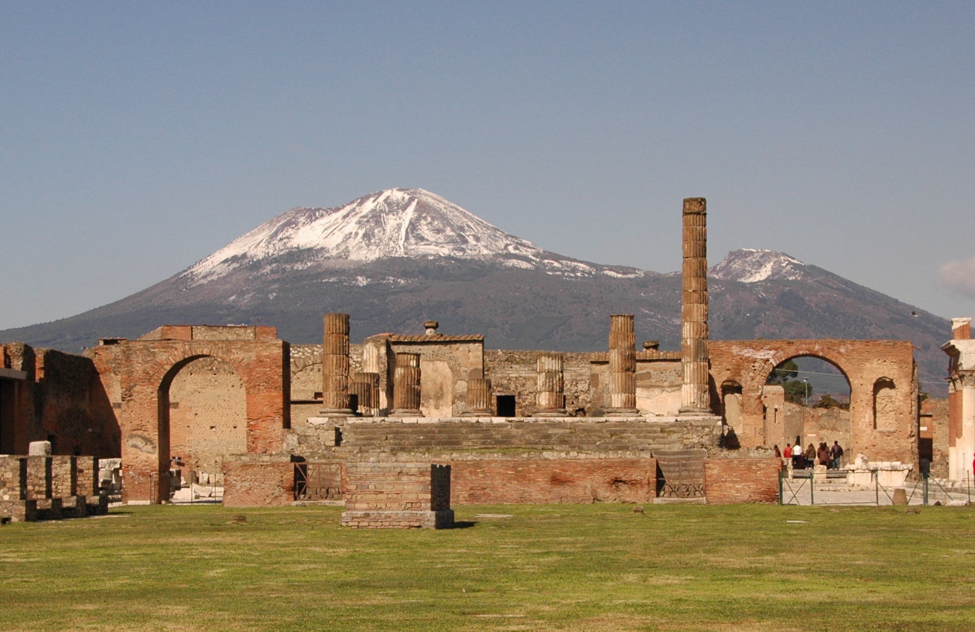
Vesuvius and PompeiiItaly’s Mount Vesuvius buried the Roman cities of Pompeii and Herculaneum in ash and pyroclastic deposits in A.D. 79. Vesuvius is a typical stratovolcano (Fig. 14a) located near today’s city of Naples, Italy (Fig. 14b). Moderate earthquakes are frequent in the region and one in A.D. 62 had already damaged the Roman cities of Pompeii and Herculaneum before Vesuvius explosively erupted on August 24, A.D. 79, sending a plume and cloud of ash and gas at least 30 km into the atmosphere. Pumice fell onto Pompeii during the first of several pyroclastic flows to engulf the city and regions south of the volcano in deposits almost 3 m thick. At least 1,500 citizens were buried beneath thick pumice and ash (Fig. V14b). A lahar buried the city of Herculaneum the next day. The explosive eruption and its sustained plume of ash was chronicled by Pliny the Younger. Similarly violent stratovolcano eruptions are therefore sometimes referred to as Plinian eruptions.
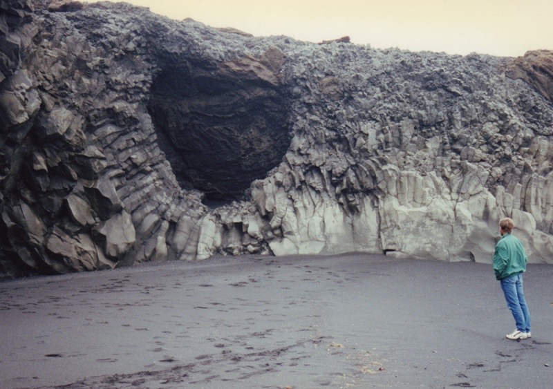
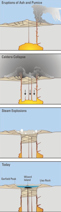
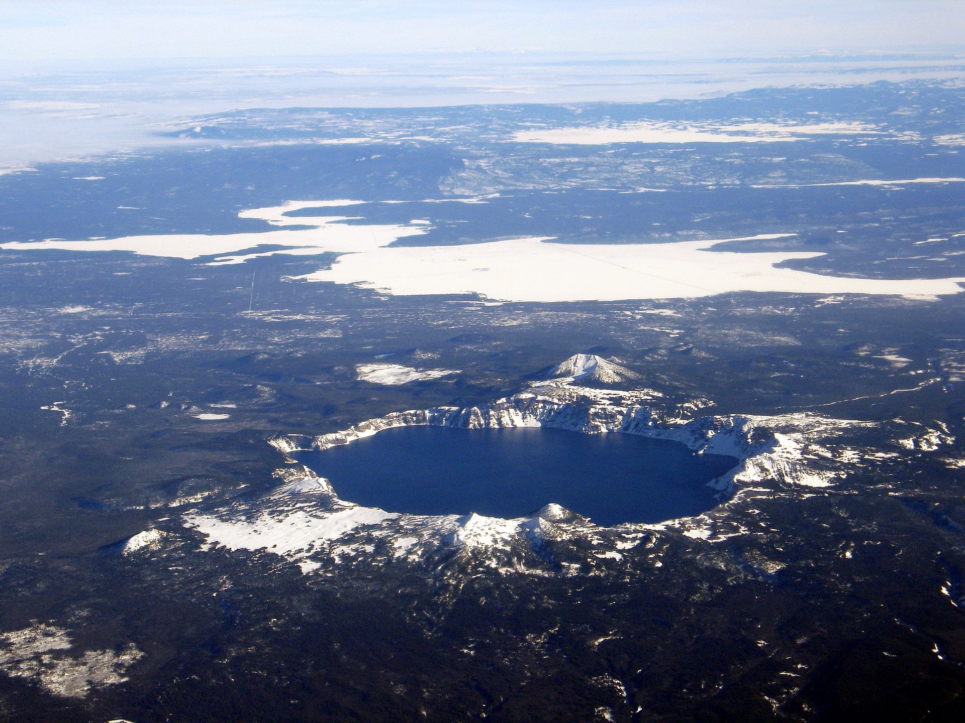
Craters And CalderasMost volcanic eruptions leave behind craters. Mega-craters, called calderas, form when a volcano collapses into its own magma chamber. Volcanic craters (Fig. 15a) form when rock around the eruptive vent is blasted away during an eruption. Calderas are mega-craters, tens of km or more in diameter, that form where the roof of the magma chamber becomes so fractured and unstable that most or even all of the volcano collapses into the partly emptied magma chamber below (Fig. 15b). The sudden reduction of pressure on the magma chamber results an explosive, catastrophic release of gases from the magma, with ejection of massive amounts of ash, pumice, and tephra (Fig. V15c), including the fragmented volcano’s original rock and ash layers. After a caldera collapse, the magma beneath is depleted in gas. As the caldera’s surface gradually cools and solidifies, the extremely sticky, gas-poor magma often resurges in lava domes that help to thicken the roof of the magma chamber.
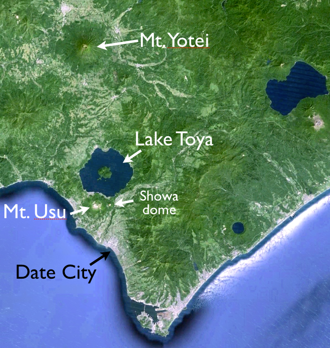
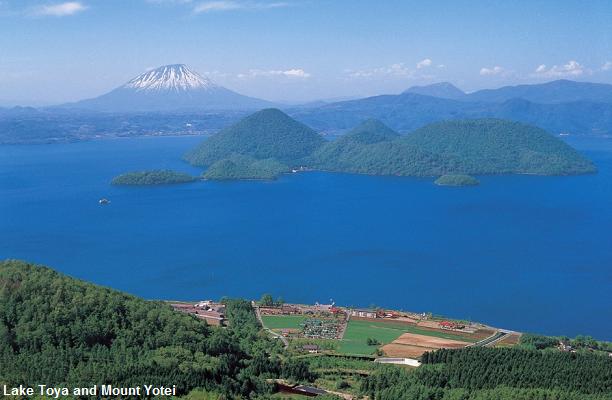
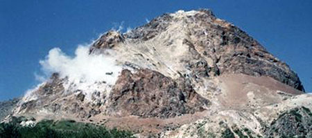
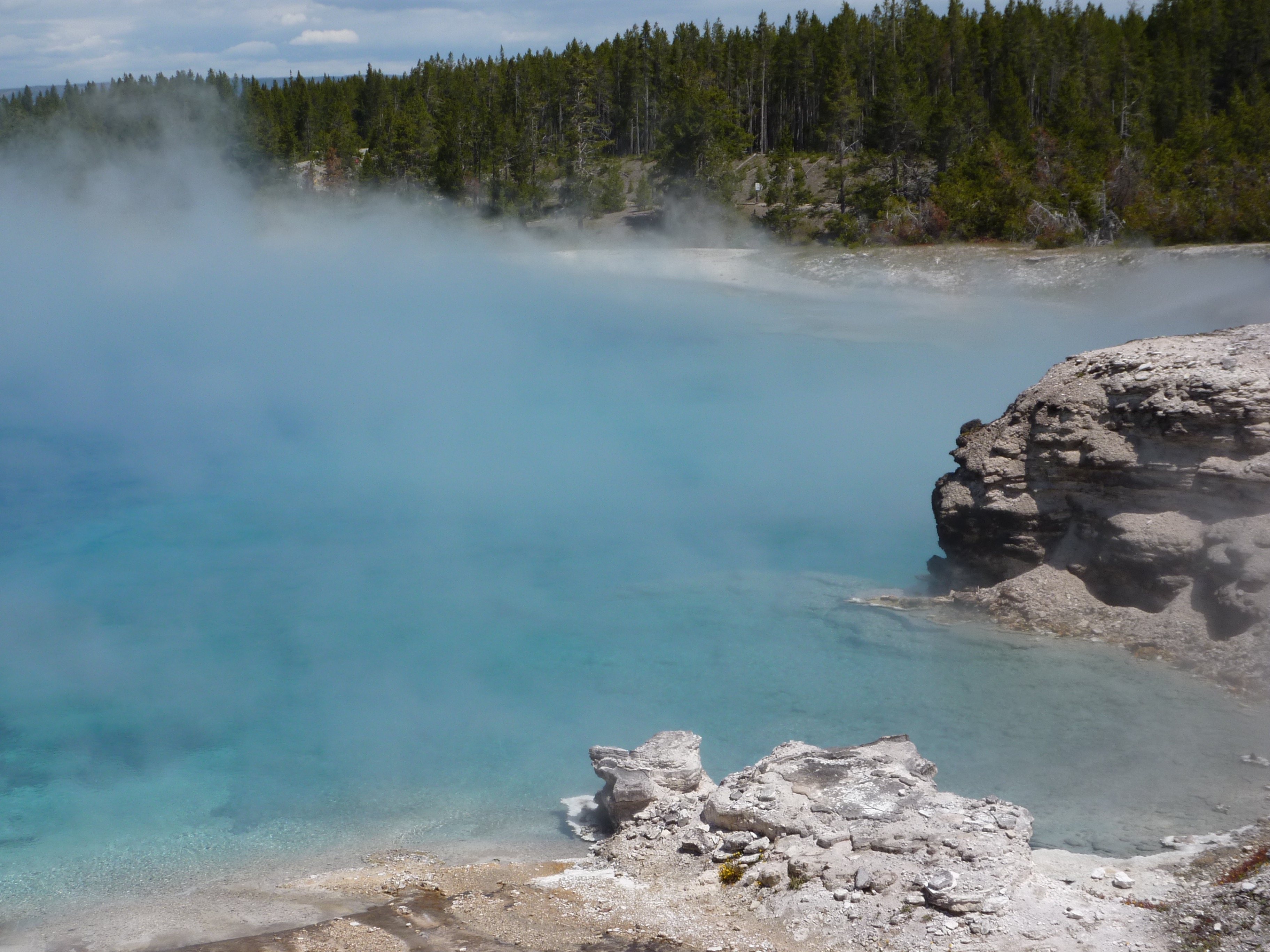
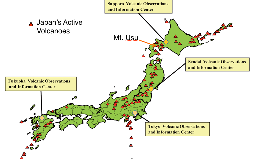
Crater Lake HazardsLakes that form inside craters and calderas are beautiful, but may also pose a significant hazard. Many tourists visit crater lakes to enjoy their clear waters and symmetrical form (Fig. 16a). However, in a volcanically active region, these lakes are a water source that can mix with ejected tephra to form deadly lahars, or form an explosive mix with lava in any subsequent eruptions. Lake Toya is a large caldera lake in northern Japan (Fig. 16b) that has central resurgent domes, hot springs around its margin, remains ice-free in winter despite its northern latitude, and is promoted as a spa resort. Mt. Usu, an active stratovolcano on the edge of the 110,000 year-old caldera, has erupted on a 30 to 50 year cycle, most recently in 1977 and 2000. On the flank of Mt. Usu, a new 400 m-high lava-dome (Fig. 16c), pushed up unexpectedly through wheat fields after a series of strong earthquakes in 1944 and 1945. The volcano is closely watched by the residents of the nearby resort city of Date, which has a population of about 40,000.
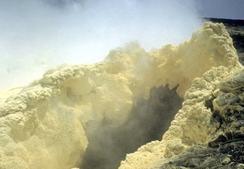
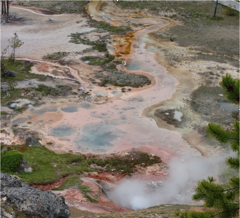
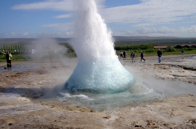
FumarolesMost of the vapor emitted from fumaroles is superheated steam, but toxic gases are also emitted and condense into acidic pools and lakes. Volcanic gases escape to surface through cracks and fissures known as fumaroles (Fig. 17a). Water vapor (steam), carbon dioxide, and sulfur dioxide at temperatures of over 400oC are the most abundant fumarole emissions. These are usually localized emissions that are relatively harmless, although they can appear without warning above active and even dormant volcanoes. The superheated gas can disperse quickly into the atmosphere, where it creates acid rain, or erupt as a hot water and gas mixture in a geyser (Fig. V17), or condense into deceptively clear, but hot and acidic pools (Fig. 17c). Other common and hot gas emissions include carbon monoxide, hydrogen sulfide, hydrogen fluoride, and hydrogen chloride, all of which are toxic and cause serious respiratory problems that can be lethal for humans and for livestock.
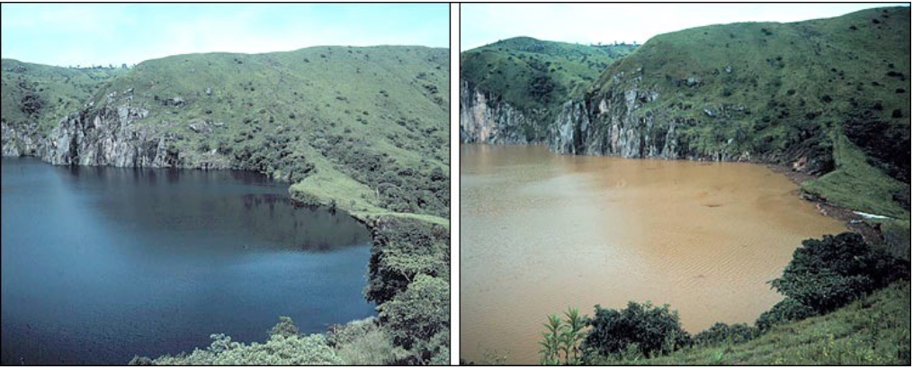
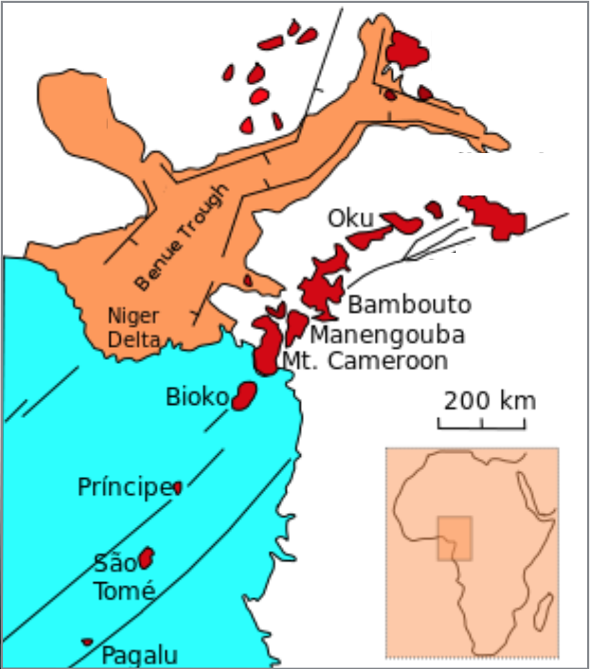
Catastrophic Gas EmissionCarbon dioxide from Cameroon’s Oku volcanoes accumulated under Lake Nyos before suddenly asphyxiating villagers and their livestock. A devastating burst of volcanic gas occurred on August 21, 1986, when more than 1,700 people and 3,500 livestock living near Lake Nyos, Cameroon, were found asphyxiated. Clues to the deaths, which occurred overnight without any property or vegetation damage, were found in the lake itself. Instead of its normal clear water, the lake looked as though it had been vigorously stirred (Fig. 18a). Carbon dioxide (CO2) from the underlying Oku volcanic field (Fig. 18b) had been building up in the lake bottom sediments. It is thought that a small landslide into the lake caused CO2 bubbles to suddenly rush to surface, just like the famous diet cola and candy experiments (Fig. 18c). The dense CO2 gas stayed close to the ground during the cool night, asphyxiating those living around the lake shores. In the morning, warmed by the Sun, the gas dispersed by convection, leaving no trace.
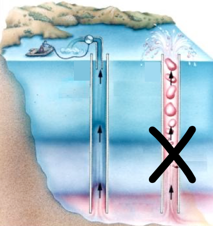
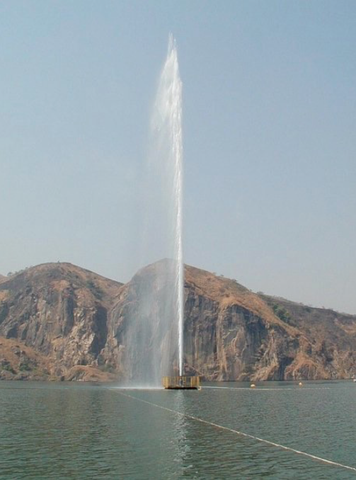
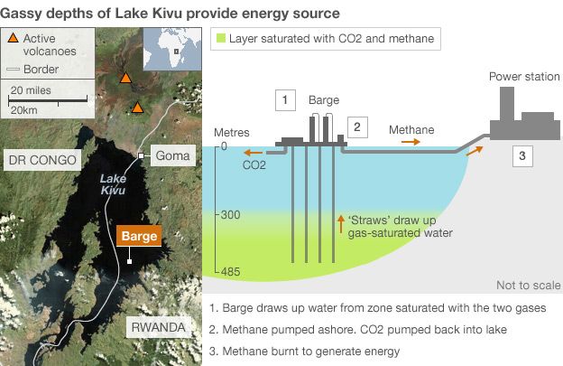
Mitigating Volcanic GasesDangerous carbon dioxide build-up in lake bottom sediments can be prevented by controlling the gas, allowing it to escape gradually to surface. Where soluble volcanic gases, such as CO2, bubble through water on their way to surface, some of the gas goes into solution, acidifying the water. Under the high pressure of deep water, such as at the bottom of a lake, CO2 can build to high concentrations. To mitigate against another catastrophic build-up of lethal gas from Lake Nyos, such as occurred in 1986 (and also to a lesser degree in 1984), a control system now releases the CO2 gas in a steady, harmless stream (Fig. V19a). Lake Monoun, also in Cameroon, and Lake Kivu in East Africa have similar problems of CO2 gas accumulation (Fig. 19b). Goma City, on Lake Kivu, was partially destroyed in 2002 when Mt. Nyiragongo erupted. Goma City’s volcano observatory now monitors the condition of Lake Kivu and Nyiragongo.
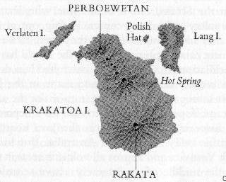
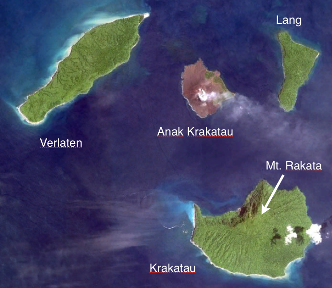
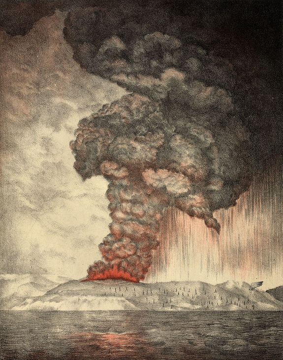
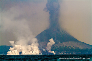
KrakatoaThe volcanic island of Krakatoa, Indonesia, exploded on August 27, 1883, causing a tsunami that killed nearly 36,000 people. Krakatoa (also called Krakatau) is one of many active stratovolcanoes in the Sunda Strait, between Java and Sumatra, Indonesia. In the 1800’s, Krakatoa was an uninhabited island in the middle of an existing 7 km-wide caldera (Fig. V20a). On August 27, 1883, the volcanic island erupted in four explosions that blew away two thirds of the island (Fig. V20b) and were heard almost 5,000 km away. Over 36,000 people were killed by the resulting tsunami. Pyroclastic flows travelled for 40 km across the surface of the Sunda Strait to the coast of Sumatra. The ash plume reached an estimated height of 80 km (Fig. 20b) and over the next year, global temperatures fell by 1.2°C. In 1927, a new volcano called Anak Krakatau (“Child of Krakatau”) appeared in the center of the caldera. The active volcano (Fig. 20b) continues to grow at an average rate of 13 cm per week.
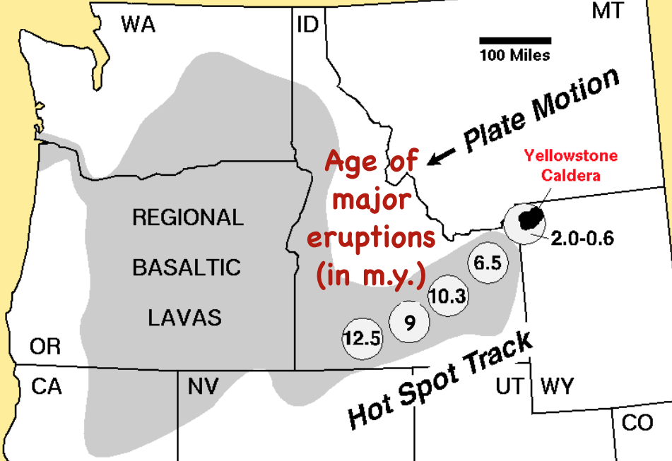
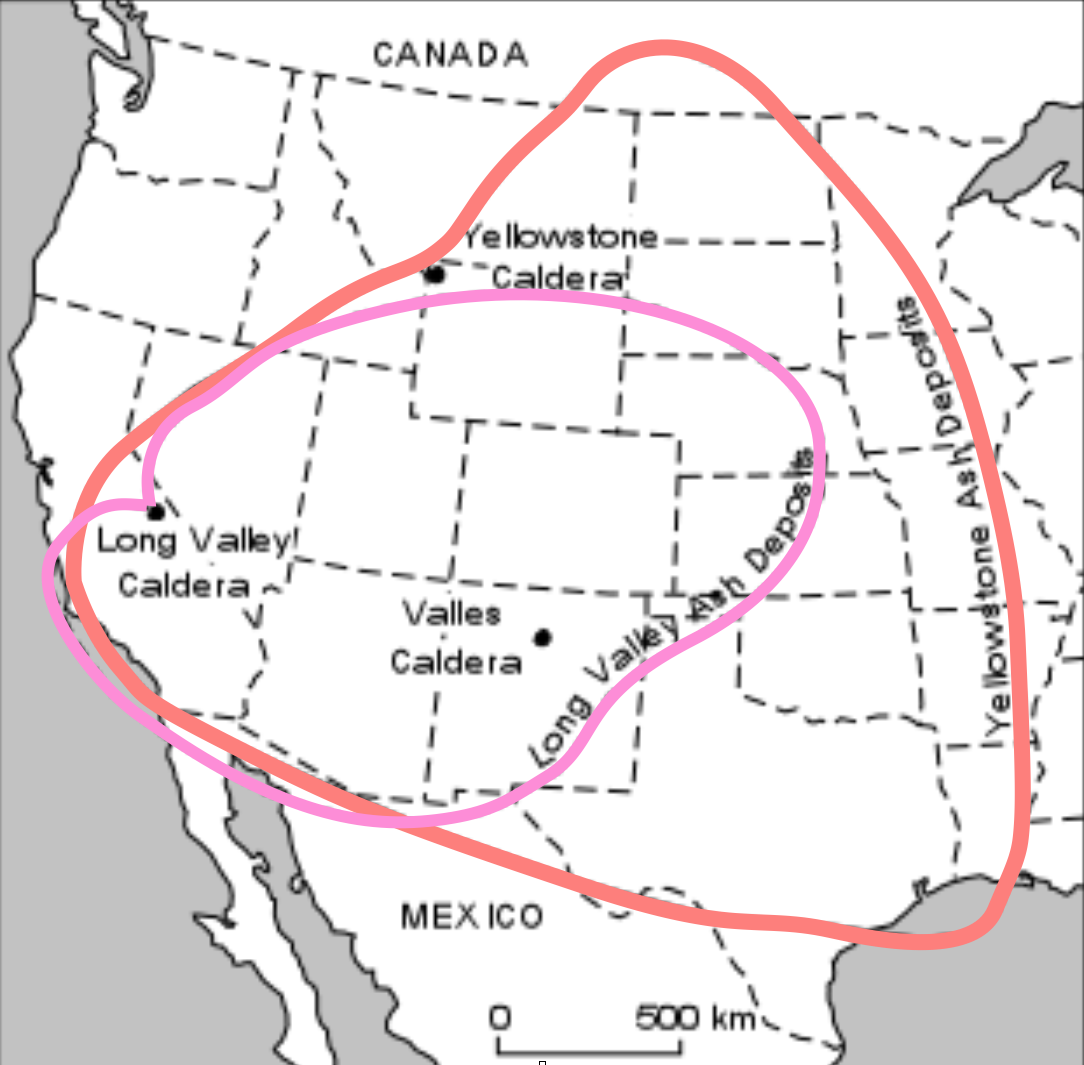
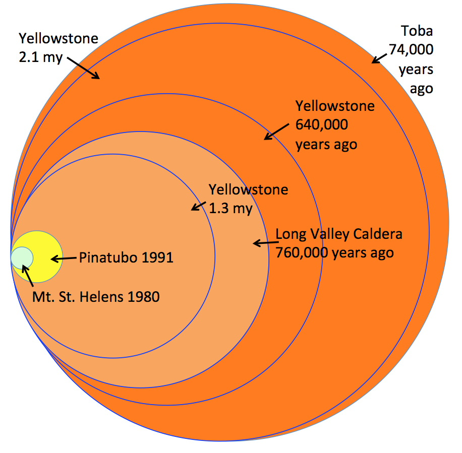
Yellowstone’s SupervolcanoA supervolcano is a volcano that produces more than 1,000 km3 of volcanic deposits in a single eruption. Yellowstone has done so, twice, along with many smaller, yet still significant, eruptions. The Yellowstone volcanic field has had a long history, starting over 16 million years ago (16 my) when the North American Plate began moving over a mantle hot spot (Fig. 21a). At 2.1 my, a single eruption produced over 2,450 km3 of ash deposits, some of which drifted well to the east of the Rocky Mountains (Fig. 21b). Another eruption at 0.64 my created the present day Yellowstone Caldera and produced over 1,000 km3 of tephra in a single eruptive event, which is now used as the definition of a ‘supervolcano’. The only larger eruption in the past 2 million years is that of Toba, Indonesia, at 0.74 my. (Fig. 21b). Yellowstone’s last eruption – mostly lava flows and a little tephra – occurred 70,000 years ago. The hot spot is now beneath the thick crust of the Rocky Mountains and therefore another cataclysmic eruption is considered very unlikely.
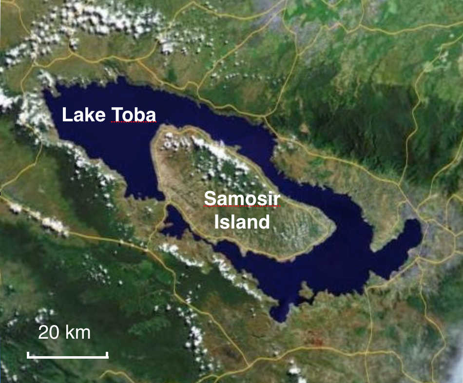
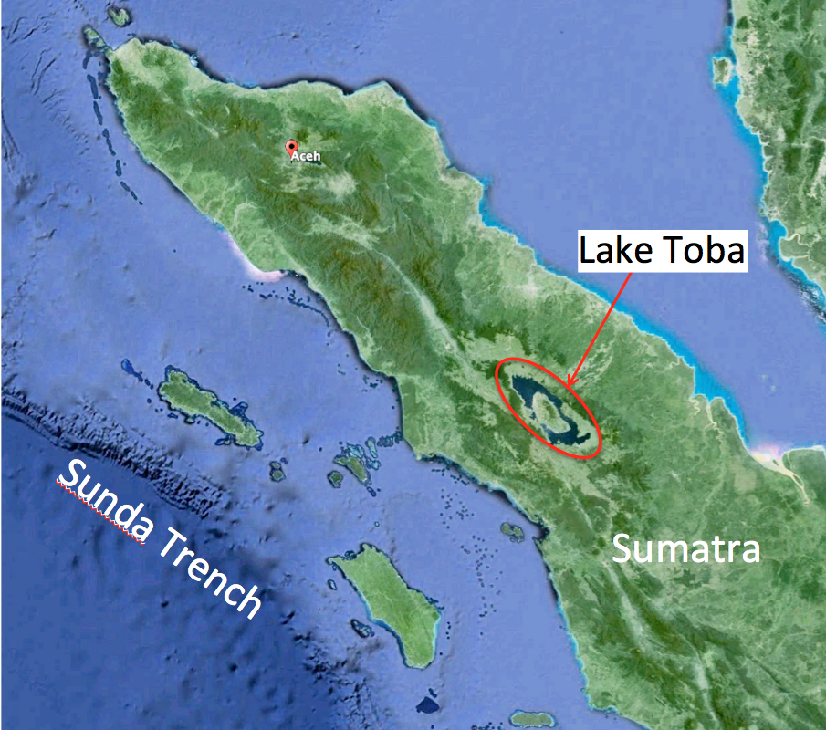
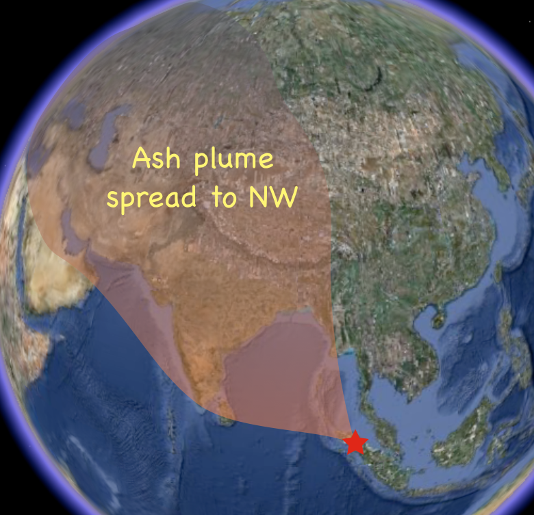
Supervolcano TobaToba erupted 74,000 years ago in a cataclysmic explosion, spewing a cloud of ash and gas that caused temporary global cooling. The biggest explosive volcanic event of the last 2 million years occurred on Sumatra, in Indonesia. Two major eruptions occurred in the region at 840,000 and 700,000 years ago, and others have occurred at roughly 400-year intervals, but these were dwarfed 74,000 years ago when one or more of Toba’s volcanoes collapsed to form a huge caldera (Fig. 22a). More than 700 million tons (2,800 km3) of ash and pyroclastic material were ejected in this supervolcano eruption. Toba’s catastrophic eruption created a plume of ash and sulfur dioxide gas that was carried by prevailing winds into a cloud that blocked sunlight over the northern hemisphere for a decade, causing at least a 3oC drop in global average temperatures. Ash fall from the eruption has been traced over much of India (Fig. 22b) and can even be detected in ice cores from Greenland. Evidence from mitochondrial DNA suggests that the combined effect of the explosion, tsunamis, and ash fall was enough to greatly reduce genetic diversity in homo sapiens at the time.
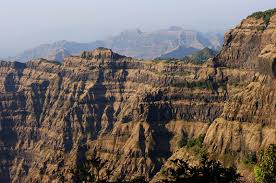
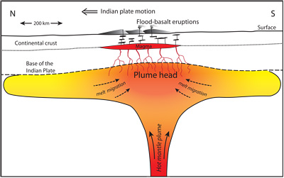
Volcanoes And Mass ExtinctionsOutpourings of lava and tephra on an enormous scale have occurred in the geological past and may have contributed to the mass extinction of species. An enormous outpouring of basaltic lava occurred 66 million years ago (66 Ma), near present day Mumbai, India. In less than 30,000 years, lava flows covered almost 1.5 million km2. About 200,000 km2 still remains as a 2,000 m-thick pile of basaltic rock known as the Deccan Traps (Fig. V3a). Global cooling caused by sulfur dioxide gas and ash from the eruptions may have contributed to the extinction of non-avian dinosaurs. At least two other enormous eruptions of basaltic lava are known to have occurred at the same time as mass extinctions of species. At 250 Ma in Siberia, and at 200 Ma in the proto-Atlantic Ocean basin, outpourings of lava occurred as supercontinent Pangea began to break apart, although direct links with the extinctions are yet to be confirmed. These massive eruptions are thought to have originated where magma above hot mantle plumes had become pooled beneath thick continental crust (Fig. 23b).
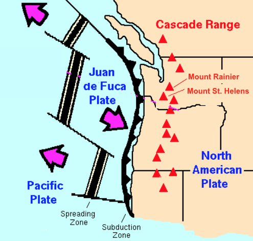
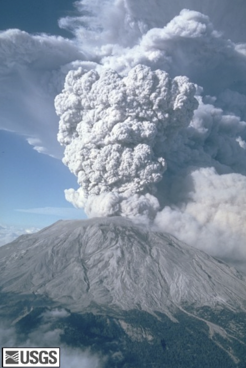
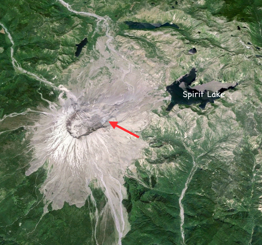
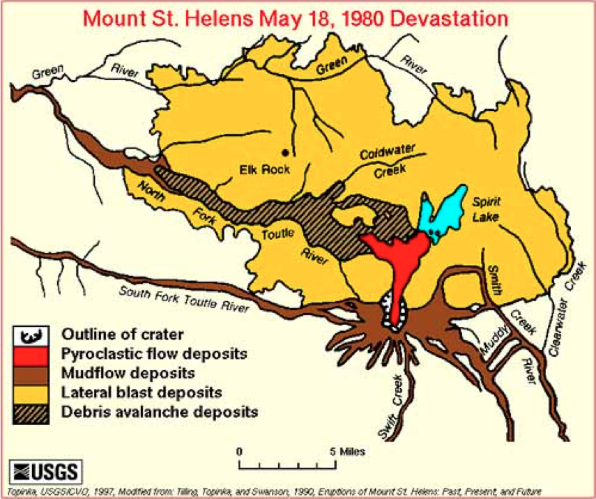
Mt. St. Helens, Cascade RangeThe 1980 eruption of Mt. St Helens in the Cascades Range of western North America unexpectedly blew away one side of the mountain. Volcanoes in the Cascade Range sit above the subduction zone between the Juan de Fuca Plate and the North American Plate (Fig. 24a). In early spring of 1980, seismic activity increased beneath Mount St. Helens and the north side of the volcano started to bulge outward. On May 18, 1980, the mountainside above the bulge unexpectedly blew apart and collapsed in an avalanche of debris. The sudden reduction of pressure on the magma inside the volcano produced an explosive lateral eruption, with a pyroclastic flow that travelled as far as Spirit Lake (Fig. 24b) and a 24 km-high ash column Lahars raced down each of the valleys that radiate from the volcano. Although a mandatory evacuation order had been issued for the region around the volcano on April 30, several individuals had been allowed back into the area on May 17 to collect belongings. In total, fifty-seven people were killed, mostly by asphyxiation, including a geologist who had been monitoring the volcano. Mount St. Helens was again active, on a smaller scale, in 2004–2008.
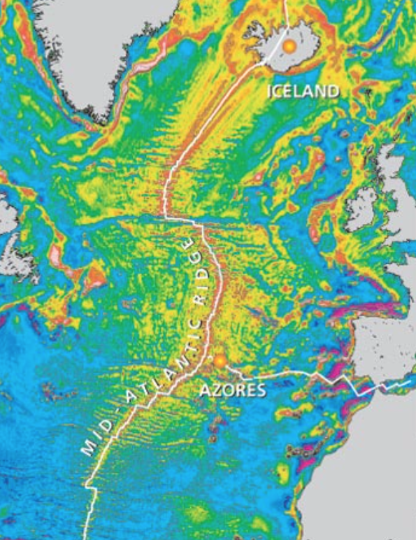
Iceland: Where A Hot Spot and Mid-Ocean Ridge CoincideIceland sits astride the Mid-Atlantic Ridge where it intersects with a mantle plume, resulting in frequent volcanic activity. The basaltic shield volcanoes along mid-ocean ridges have low-elevation and usually remain well below sea level. One notable exception is Iceland, on the Reykjanes Ridge section of the Mid-Atlantic Ridge. Gravity data obtained via satellite shows abnormally elevated ocean crust around Iceland (Fig. 25a), indicating that the ridge coincides with a mantle hot spot thermal anomaly. Iceland is composed entirely of basaltic rock from at least 130 volcanoes, of which 18 have been active in the past 1,000 years. Recent eruptions have been mainly in the south, along a new branch of the spreading ridge (Fig. 25b). In 1963–1969, offshore eruptions resulted in the formation of the new island of Surtsey. Heckla, which last erupted in 2000, and Eyjafjallajökull which erupted in 2010, are two of the most active volcanoes on the island.
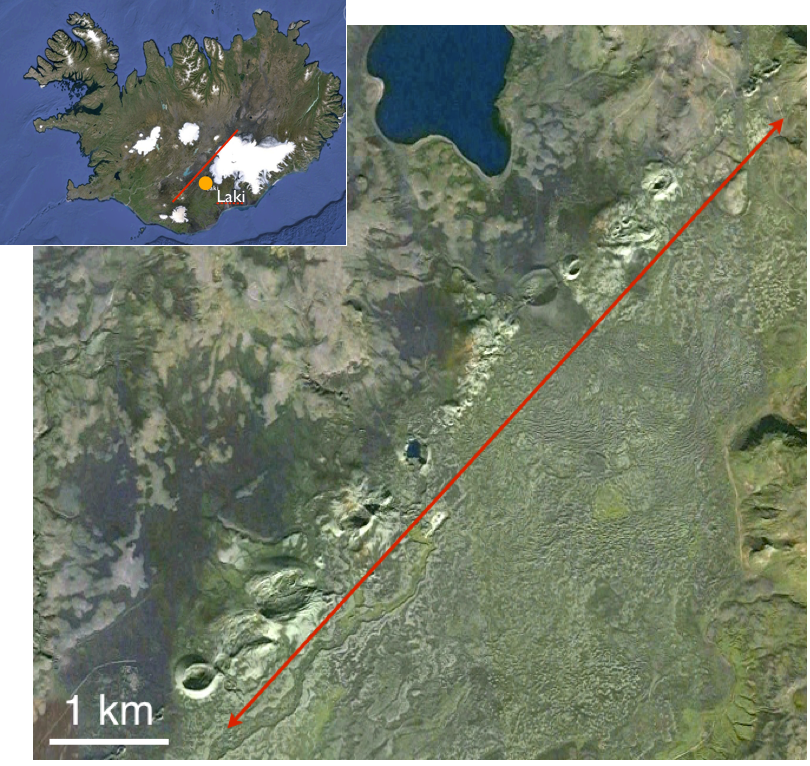
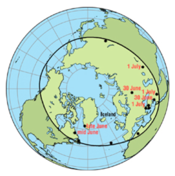
Iceland’s Dry Fog Of 1783Toxic gases from the Laki eruption of 1783-84 caused a widespread dry fog that reduced sunlight, produced acid rain, and damaged crops. Beginning in May 1783, lava eruptions from the Laki Fissure on the Reykjanes Ridge, southern Iceland (Fig. 26a), destroyed several farms and villages. However, the most devastating effect of the eruption was a release of toxic gases in the form of a dry fog that blanketed Iceland and extended to much of the northern hemisphere in the summer of 1783 (Fig. 26b). Solar energy in the fog-covered regions was greatly reduced, making the winter of 1783-4 the coldest in 250 years. Unlike a water-based fog, the ash- and sulfur-rich haze did not evaporate in sunlight. Acid rain and poisonous fumes severely damaged Icelandic grasslands and crops, decreased the Icelandic fish catch, and caused 50% of Iceland’s livestock to die within the year. Thousands of Icelanders died as a result of famine and respiratory problems, reducing the population of the island by 25%.
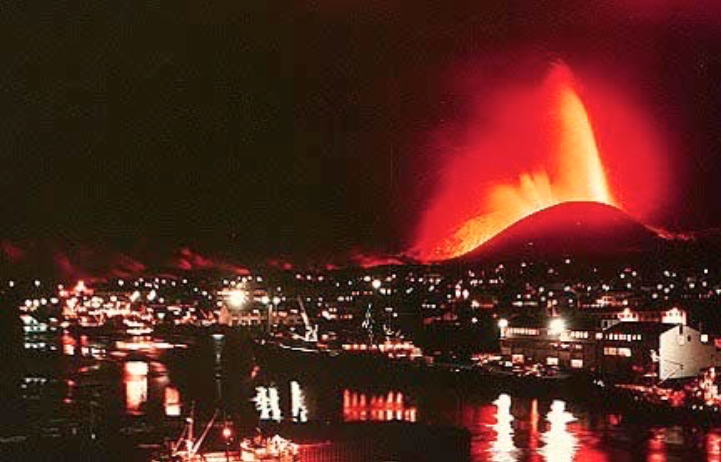
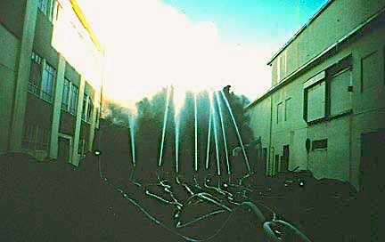
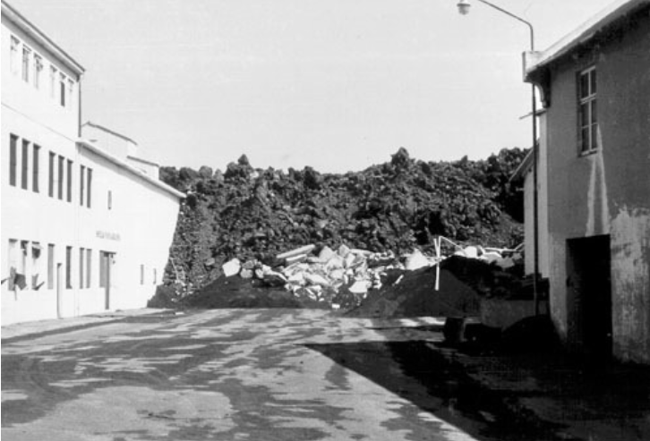
Trying To Stop A Lava FlowDrenching a lava flow with cold water may slow it down, although it is unlikely to stop it altogether. Iceland’s volcanoes have erupted many times since the island was settled and the islanders have learned to mitigate some of the damage they cause. In January 1973, Eldfell volcano erupted close to the fishing port of Vestmannaeyjar, in southern Iceland (Fig. 27a). Fishing vessels were used to evacuate most of the port’s citizens. The Icelanders erected protective barriers, but still a total of 400 buildings were destroyed by lava flows and tephra falls. As lava encroached on the harbor’s entrance, an attempt was made to freeze the molten rock by drenching it with millions of cubic meters of seawater (Fig. 27b). This approach was not entirely successful in stopping the flow, but may have helped to save some properties (Fig. 27c). After a few months, Eldfell’s eruptive activity ceased. The damaged parts of the town were eventually rebuilt and heat from the cooling lava was used to construct a district heating system.
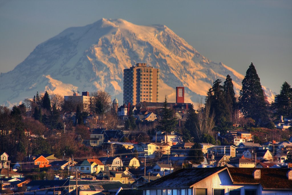
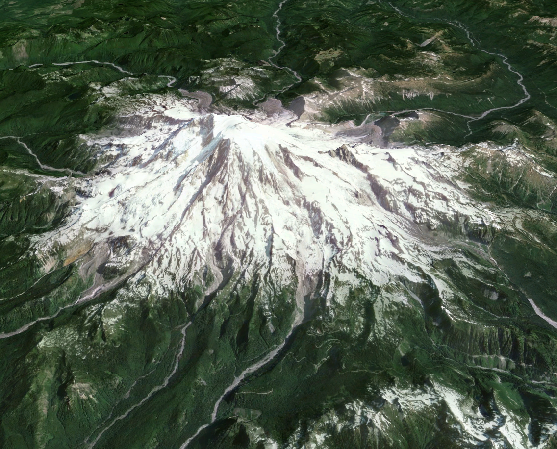
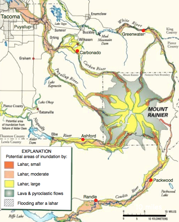
Volcanic Hazard MapsHistorical records of past eruptions are used to create hazard maps, which indicate the likelihood and type of a future event in a particular location. Understanding the risks from an active volcano depends to a large extent on knowing its past behavior. An example is Mount Rainier (Fig. 28a), an active volcano in the Cascade Range near the city of Tacoma, U.S.A. It has erupted four times in the past 11,000 years, the most significant event being 2,200 years ago, and is being closely monitored for any signs of renewed activity. A volcanic hazard map (Fig. 28b) has been constructed for areas surrounding Mount Rainier, based on past lava and pyroclastic flows, lahars, and present day geography. The map shows the most vulnerable areas in the valleys that radiate from the volcano. Volcanic hazard maps are not, however, foolproof. Nearby Mount St. Helen’s lateral blast in 1980 was unpredicted. The resulting landslide and volcanic debris covered an area 15 times greater than shown on its hazard map.
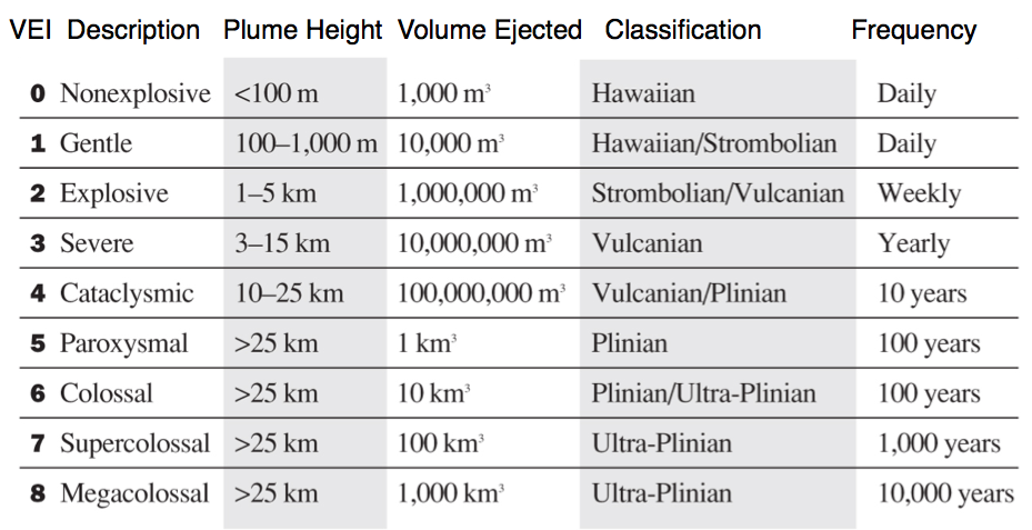
Measuring ExplosivityThe Volcanic Explosivity Index (VEI) expresses the violence of historic volcanic eruptions on a logarithmic scale. In 1982, researchers from the US Geological Survey and the University of Hawaii developed the Volcanic Explosivity Index (VEI) as a tool for use in assessing the likelihood of future violent eruptions from the world’s active volcanoes. The VEI expresses the relative violence of historic volcanic eruptions on a logarithmic scale of 0 to 8 (Fig. 29a). Assignment of a VEI of 0 means that eruptions are non-explosive, have a low volume of ejecta, a low (or no) ash plume height, and occur frequently. The basaltic shield volcanoes of Hawaiian Islands, such as Kilauea, are typically VEI 0. An eruption of VEI 8 is what we now call a supervolcano, a rare event with over 1,000 km3 of ejecta and an ash plume height of over 25 km, such as Yellowstone and Toba. For comparison, the Mount St. Helens eruption of 1980 was VEI 5, Krakatoa (1883) and Pinatubo (1991) eruptions were each VEI 6, and Tambora (Fig. 29b) in 1815 was a VEI 7.
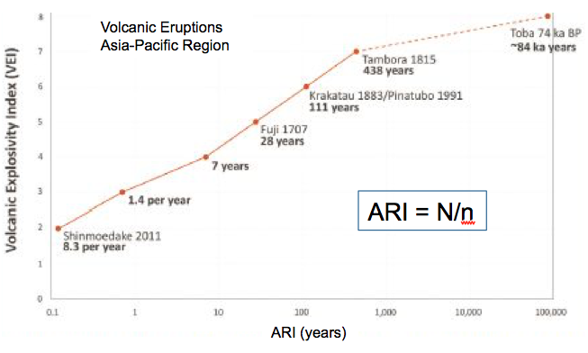
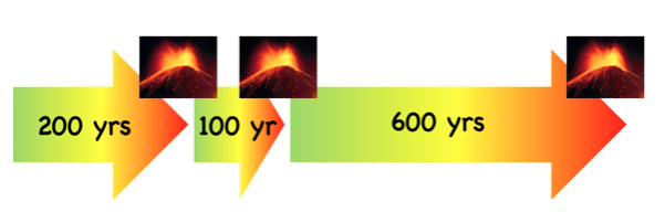
Eruption RecurrenceThe average time between eruptions is the eruption recurrence interval – an indicator, but not an accurate predictor, of future events. Anyone who lives near an active volcano (and their insurance companies) would like to know when the next eruption will occur. A measure often used is the Average Recurrence Interval (ARI), which is the average frequency of eruptions. To calculate ARI, it is necessary to know the number, n, of eruptions that occurred in time period N, which can range from years to tens of thousands of years (Fig. 30a). To estimate ’n’ often requires detailed geological research as well as data from historical records where these are available. Unfortunately, ARI is not very useful for small data sets (Fig. 30b) and says nothing about the possible magnitude of the event. Furthermore, even the best-behaved volcanoes can be unpredictable if the composition of the magma changes, or if new fractures or feeder pipes open to the surface such as after an earthquake.
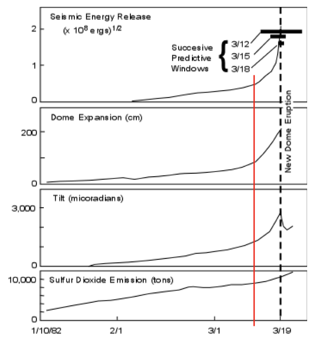
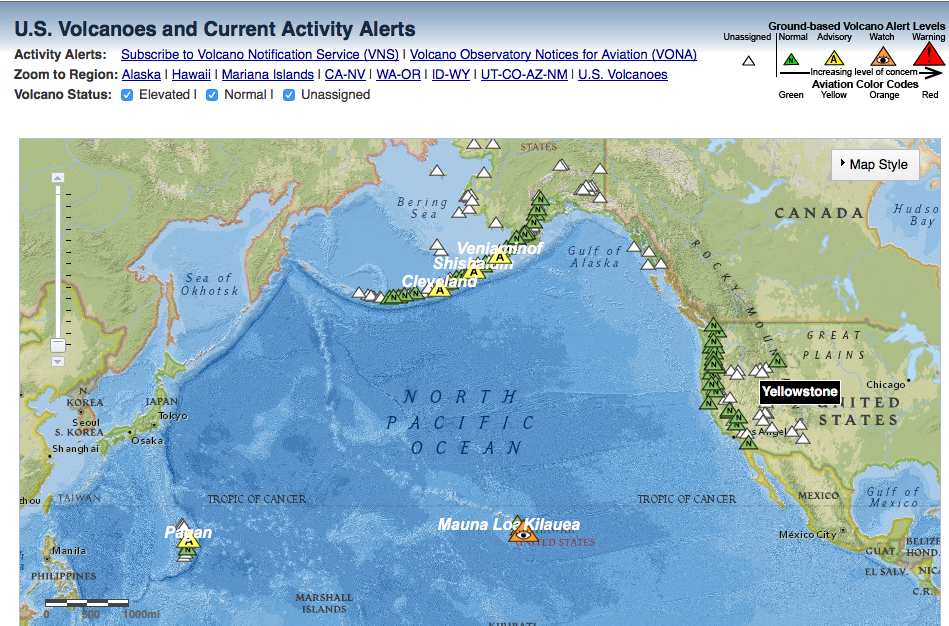
Monitoring Active VolcanoesAll active volcanoes around the world are now monitored for signs of an imminent eruption. As magma moves around inside a volcano, it fractures the surrounding rock, creating numerous micro-earthquakes. A significant increase in local seismic activity is therefore one indication than an eruption is likely. An increase in the quantity of gas emitted or a change in gas composition may indicate that magma is degassing its approach to surface. Changes in the volcano’s shape, such as steepening slopes or development of an unusual bulge on one flank, can also indicate that an eruption may be imminent (Fig. 31a). Although the timing of an eruption cannot be predicted with absolute certainty, most active volcanoes exhibit one or more of these precursor activities. There are now several international and national programs to monitor active and potentially active volcanos (Fig. 31b), and provide timely warnings to the public on the need to evacuate or take other precautionary action.
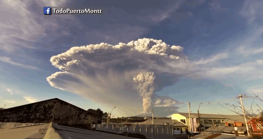
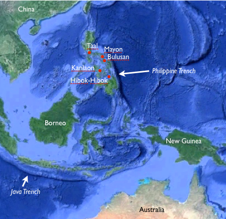
Mitigation Of Volcanic Hazards By EvacuationSuccessful mitigation of the effects of an eruption requires a well-executed preparedness plan and a willingness of the population to evacuate. Two examples show how effective a full-scale evacuation can be in mitigating the effects of a volcanic eruption. In March 2000, Mt. Usu volcano in Japan (Fig. 32a) erupted after an interval of 23 years. An increase in earthquake activity near the volcano in the previous few days had triggered the evacuation of over 16,000 residents and tourists – the result of well-organized preparedness planning. Mt. Usu erupted 36 hours after the evacuation, causing no injuries or loss of life. In September 2014, the Philippine Institute of Volcanology and Seismology, which monitors the activity of all 25 active volcanoes in the Philippines (Fig. 32b) observed increased seismic activity and rockfalls at the Mt. Mayon stratovolcano and issued an evacuation advisory. More than 12,000 people were evacuated from areas near the volcano prior to Mt. Mayon’s eruption, which was relatively minor. Unfortunately, volcanoes seldom behave exactly as predicted and citizens may resist future evacuations if a previously predicted eruption did not occur or was small in scale.
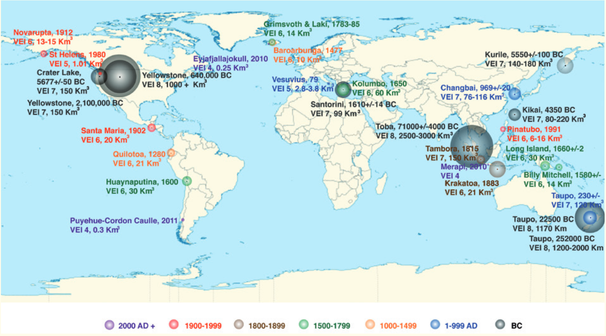
Promoting ResilienceResilience is defined as the ability to adapt to adverse circumstances. Providing information about volcanic risks does not mean precautionary measures will always be adopted. In a study published in 2000, researchers in New Zealand showed that 92% of city residents in Auckland were very aware of the likelihood of volcanic ash fall from nearby active volcanoes, however only 10% had stored food and water, 9% had a first aid kit, and 7% had an emergency radio. The study suggests that even where the hazards of living adjacent to active volcanoes are well communicated and understood, people may overestimate their own capability for resilience and may also assume that the authorities will take responsibility for everyone’s safety. Wide-scale community cooperation and trust are necessary to ensure adequate resilience to the rare, but potentially catastrophic, violent volcanic eruptions of the future. Figure 33 shows the frequency of eruptions greater than a VEI of 4 over the past 2 million years – roughly since the time that early humans began to spread round the globe. Although the VEI map in Figure V33 does not take into account the destruction from lahars or the effect of large volume gas emissions, the overview provides an indication of the potential volcanic risks for which populations in various parts of the world need to be prepared.
Class Reading ListPlag, H.-P., Brocklebank, S., Brosnan, D., Campus, P., Cloetingh, S., Jules-Plag, S., Stein, S., 2015. Extreme Geohazards — Reducing the Disaster Risk and Increasing Resilience. European Science Foundation. pdf. Oppenheimer, C., 2003. Climatic, environmental and human consequences of the largest known historic eruption: Tambora volcano (Indonesia) 1815. Progress in Physical Geography, 27(2), 230-259. Doi: https://doi.org/10.1191/0309133303pp379ra. Decker, B. B., Decker, R. W., et al., 2017. Volcano. Encyclopaedia Britannia, html. Miles, G. M., Grainger, R. G., Highwood, E. J., 2003. Volcanic Aerosols: The significance of volcanic eruption strength and frequency for climate. Q. J. R. Meteorol. Soc., 128, doi: 10.1256/qj, pdf. |