Fall 2018: Natural Hazards and Disasters
Natural Hazards and Disasters
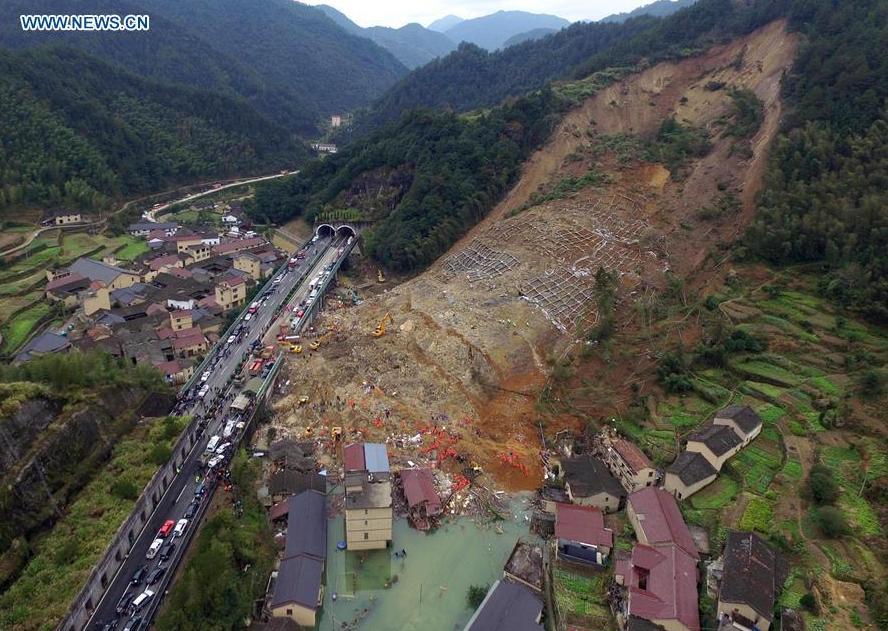
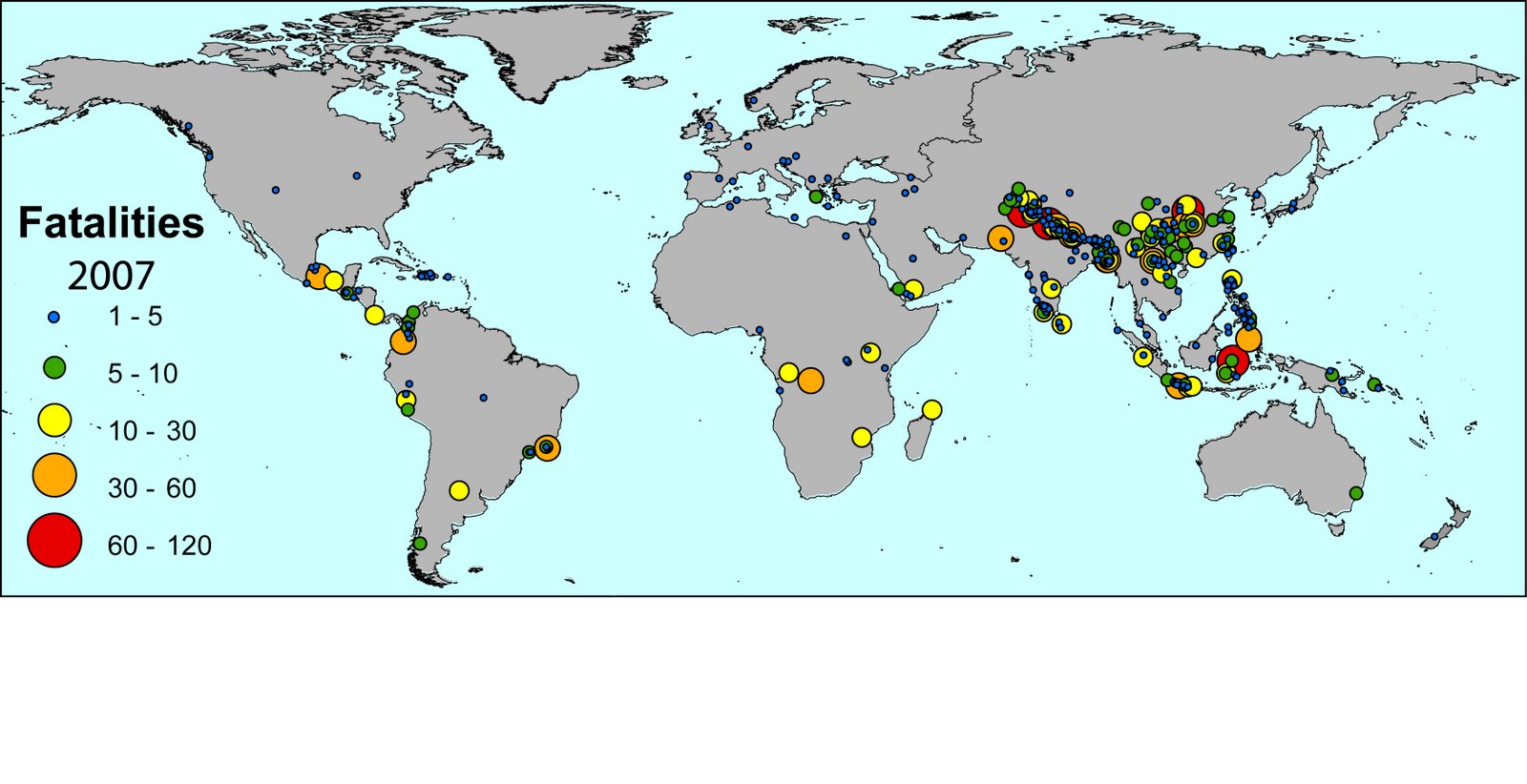
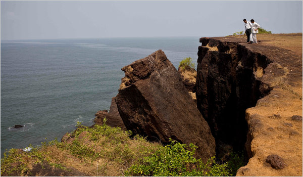
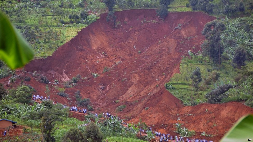
Class 7: Landslides and Ground InstabilitiesLandslidesLandslides are large volumes of loose rock and/or soild that move downslope, more or less as one mass, under the force of gravity. The general term landslides is used for a wide range of downslop movements of rock and soil. The general term ‘landslide’ is used for a wide variety of downslope mass movements of rock or earth along with any associated vegetation (Fig. L1a). . They can occur on steep slopes anywhere, but are most frequent in mountainous regions, along steep river banks, coastal cliffs, and in regions of active tectonic uplift, such as on convergent plate boundaries, especially where earthquakes and/or heavy rains are common. Landslides are responsible for thousands of deaths and injuries, and billions of dollars in property damage worldwide each year. A study published in 2012 documented more than 32,300 fatalities caused by landslides in the 7-year period between 2004 and 2010, with the majority of deaths occurring in the Himalayan mountains and earthquake-prone regions of China (Fig. L1b).
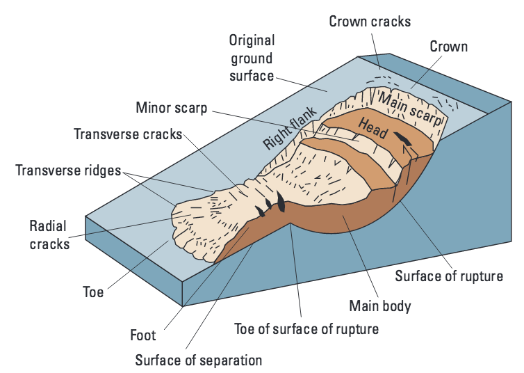
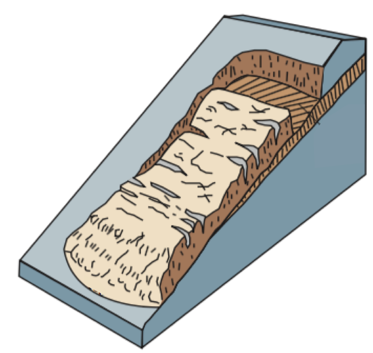
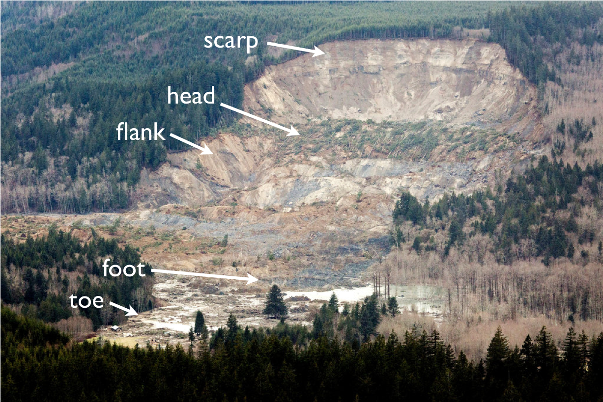
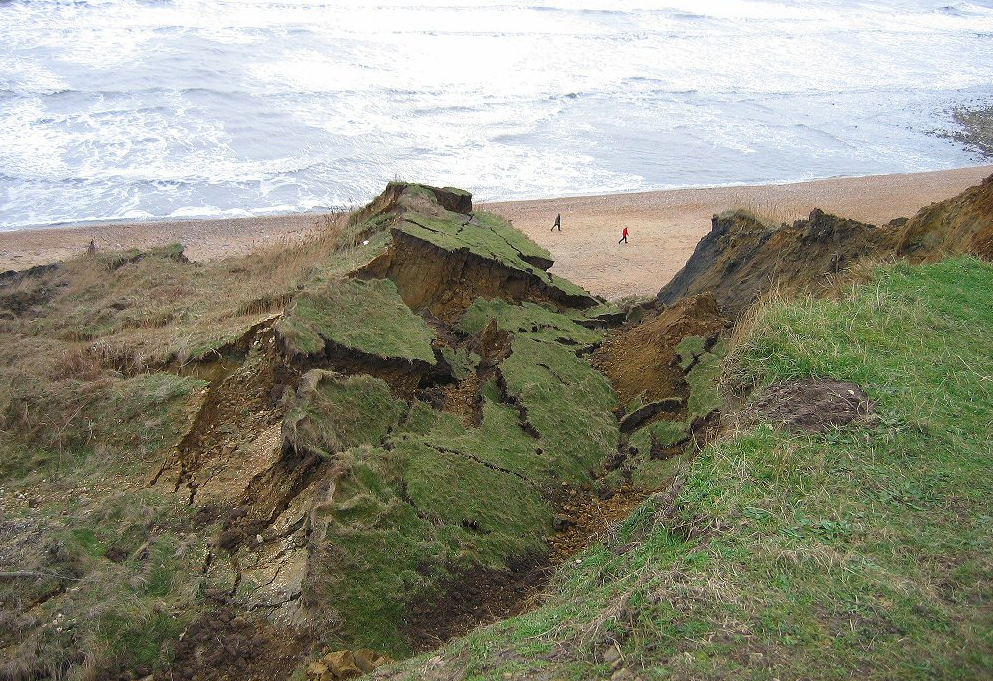
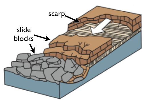
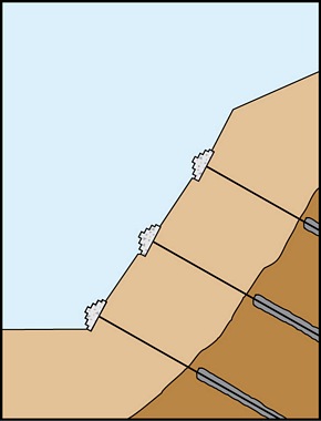
Landslide TerminologyLandslide terminology has parallels with human anatomy, with a crown, head, body, foot, and toe. Regardless of the size of a landslide, the basic morphology is similar in all cases (Fig. L2a). The loosened material slumps or slides downhill on a basal rupture surface that separates the landslide from intact material below. The rupture surface can be curved, as in a rotational slump or slide (so called because the sliding blocks rotate about a horizontal axis as they move downhill), or planar, as in a translational slide (no block rotation). A bare scarp surface is left between the ‘crown’, above the landslide, and the topmost surface of the slide, which is called the ‘head’(Fig. L2b). often there are numerous minor scarps and transverse cracks, some of which can develop into scarps, in the ‘body’ of the landslide. Much of the devastation from large landslides occurs at the ‘foot’ and ‘toe’ of the slide (Fig. L2b), which can run out for significant distances down-valley and spread out into lobes across-valley.
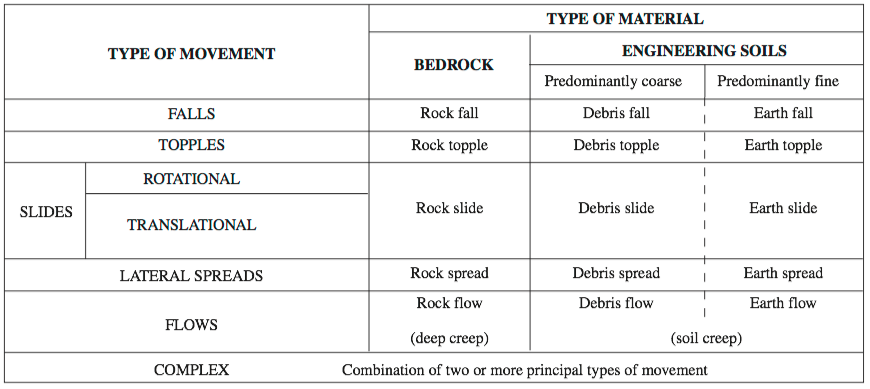
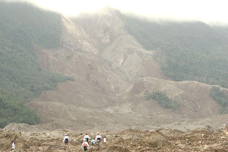
Landslide TypesLandslides are classified on the type of movement that occurs and the type of material involved. The classification of landslides is based principally on the type of movement that occurs (Fig. L3a). All are the result of gravity acting on the rock or earth, aided by water, and/or vibrations such as earthquakes or repeated pounding of storm waves on cliff faces, and all require moderate to steep slopes. Most of the landslides that cause major destruction to people and property are either slides or flows, or have some combination of these two movement types. Rotational debris and earth slides (Fig. L3b), also known as slumps, are among the most common and they can also be the most deadly (Fig. L3c). These slides frequently become debris or earth flows that can travel significant distances as the loose material moves rapidly downhill, entrapping air and water so that the foot and toe of the slide behaves as a fluid.
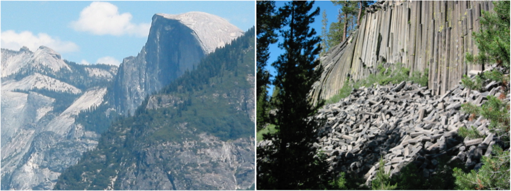
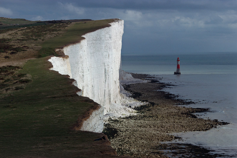
Cohesive StrengthThe cohesive strength of a material, whether rock, loose sand, or dirt, is its ability to hold together. Porous rocks like sandstone have a lower cohesive strength than hard rocks like granite and basalt. A rock’s minerals and grains bind together to give the rock its cohesive strength, in other words its ability to hold its internal constituents together. Some rocks, such as granite and basalt, have a very high cohesive strength. They can form stable vertical cliffs and overhangs (Fig. L4a), which rockclimbers enjoy. Blocks of rock that fall from the cliff form a mound of talus, also called scree, at the cliff’s base. Other rock types, particularly sedimentary rocks such as sandstones and limestones, are more porous, with rather low connectivity between grains, and therefore they have a lower cohesive strength than granite. Although many of these rocks are also able to form steep cliffs (Fig. L4b), they are much less stable than granite cliffs and loose blocks are prone to fall: rock-climbers generally avoid climbing on them.
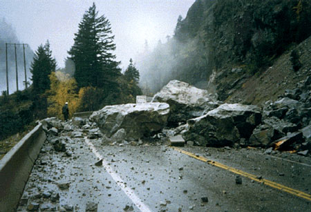
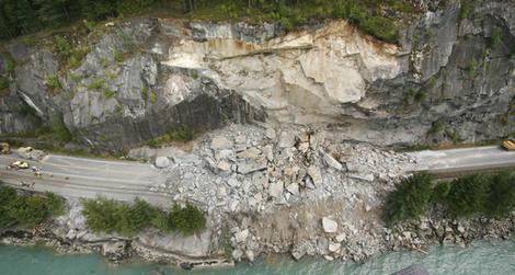
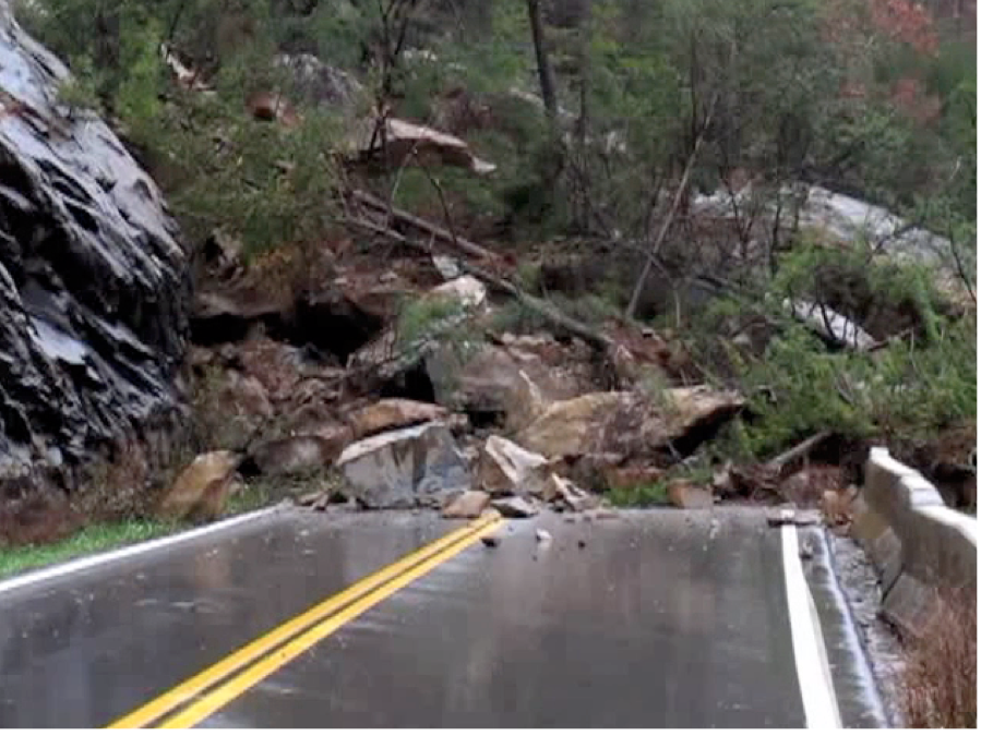
Rock Falls And TopplesRock falls are the sudden detachment and free fall of blocks of rock from very steep slopes and cliffs. Topples are falls that pivot outward before falling. Rocks lose much of their cohesive strength when they are fractured. The more fractures in the rock, the more likely will blocks fall from steep, rocky slopes and cliffs. Water or ice opens up preexisting cracks and separation planes in the rock, loosening the blocks which then detach from the cliff face either by dropping straight downward (rock fall, Fig. 5a) or by pivoting outward before falling (rock topple, Fig. 5b). In mountains that receive winter snows, fractures often open up during the spring thaw season, making this an especially dangerous time of year for rock falls. Rock falls occur suddenly, especially in or shortly after heavy downpours of rain, or in earthquakes when the shaking motion further loosens blocks, and they can be highly inconvenient when they disrupt traffic (e.g., Fig. L5a), although they seldom have more than a local effect.
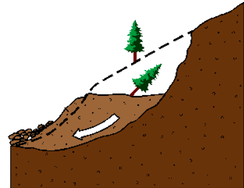
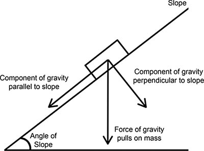
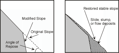
Rock Slides And Slope AngleFrictional resistance to sliding is lower for steep slopes than for gentle slopes, therefore a main rock slide trigger is slope steepening. Landslides can be triggered by any action that reduces the frictional and cohesive forces holding material in place on a hill slope. Gravity acting on a sloping surface has two components: one that pulls perpendicular to the slope, providing frictional resistance to downhill movement, and one parallel to the slope of the surface, which drives the downhill motion (Fig. L6a). Frictional resistance to sliding of a rock mass is greatly reduced on steep slopes and by water on the slope’s surface beneath the mass. All hill slopes, regardless of size, have a natural angle of stability, called the angle of repose, that varies with the material. If the slope is steepened beyond its angle of repose by tectonic or volcanic uplift, or by removal of material at its base (Fig. L6b), slumping of material from above will likely occur to restore stability (Fig. L6c).
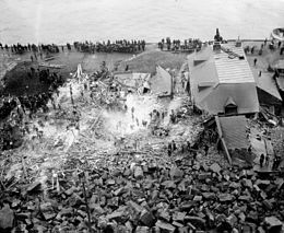
Rock Slides On Weak ZonesRock slides can occur on quite moderate slopes, if aided by water or weak zones within the rock. Many rocks contain natural zones of weakness within them, such as original layering when the rock’s constituent grains were deposited in sedimentary strata, known as beds, under water. Thin, clay-rich beds and layers that are rich in very weak minerals, such as gypsum, have lower strength than thick, sandy beds. Weak zones in rock also occur as a result of tectonic movements. Blocks of rocks are especially liable to slide on these weak surfaces where the strata are tilted (Fig. L7a) and when the weak zones are further lubricated by water (Fig. L7b). On September 19, 1889, a rock slide from the Cap Diamant cliff in Québec City, Canada, killed more than 40 people (Fig. L7c). The slide occurred in a location that had seen three previous fatal rock slides, but houses situated across the road from the cliff had been considered safe even after the earlier slides – until the 1889 slide proved otherwise.
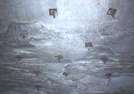
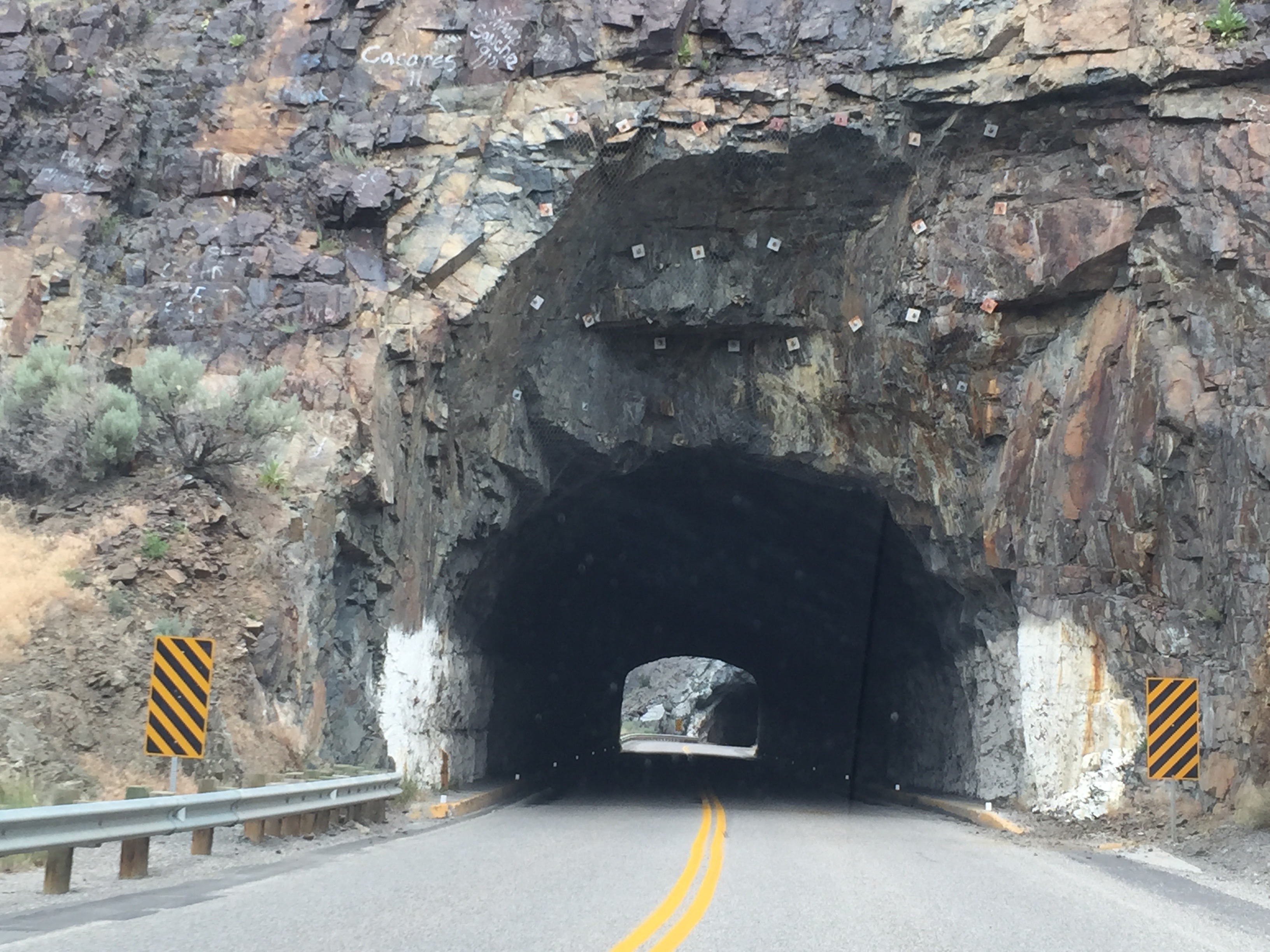
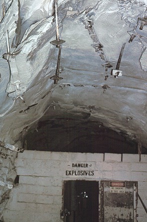
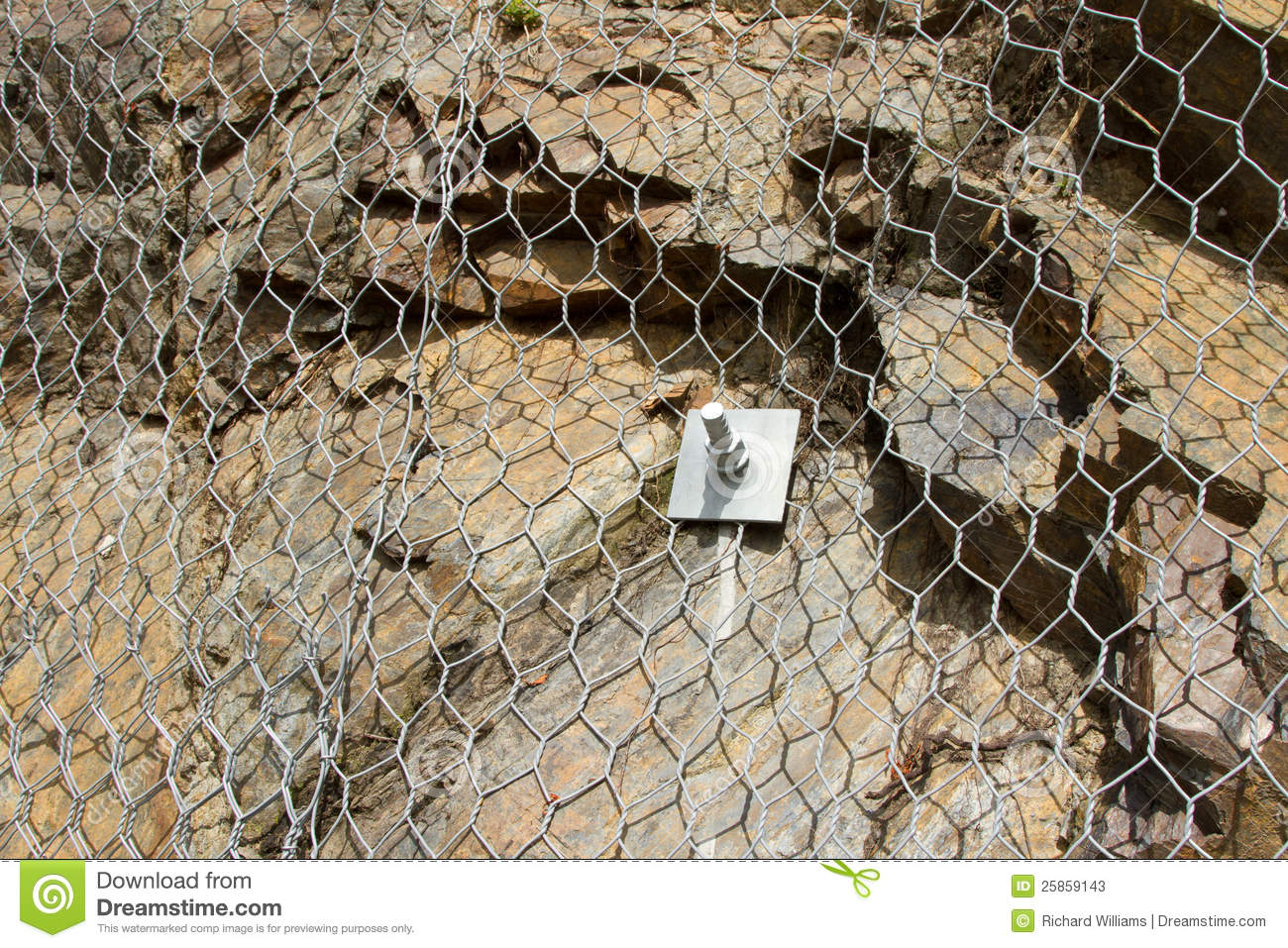
Mitigation Of Small Scale Rockslides With Rock BoltsRockslides on a small scale can be partly mitigated by rock bolts with or without wire netting. A rock bolt is an anchoring screw that is used to secure potentially loose slabs of rock to more intact rock (Fig. L8a). Rock bolts are very commonly used to secure tunnel roofs in mines and in road and rail cuts (Fig. L8b). To be effective, they must be arranged in closely spaced groups with the pattern determined by the type of rock and the size and shape of the loose slabs. On a larger scale, rock slopes can be party stabilized with wire safety netting (Fig .L8c). This type of mitigation is commonly used in road and railway cuttings where the loose rock slabs are relatively small. As blocks are dislodged by rain or vibrations, they collect at the bottom of the netting where they can be periodically cleared away as necessary. This approach is really only successful on a small scale, with rock that has relatively few weak zones beneath the exposed slope surface.
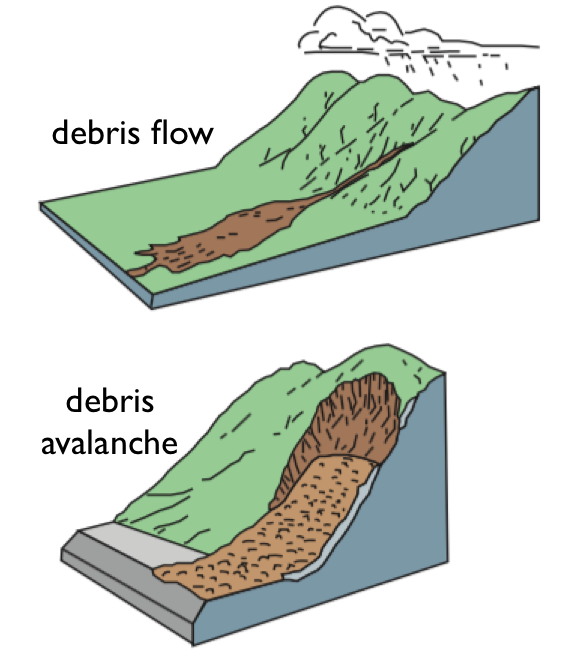
Debris FlowsDebris flows and debris avalanches are each a type of fast-moving, wet landslide in which over 50% of blocks in the flow are at least pebble-sized. A debris flow is a wet mixture of rocks and earth, known as a slurry, that moves suddenly and rapidly downslope, usually within steep, narrow gullies (Fig. L9a). Debris flows need a large amount of loose material (e.g., Fig. L9b), and are more likely to occur where there is little vegetation because the presence of tree roots helps to anchor loose soil and small rocks. When the loose material becomes saturated with rain or snowmelt, or shaken such as by an earthquake or a volcanic eruption, it loses cohesion and gravity moves the mass rapidly downhill. The distinctions among debris flows, debris avalanches, and mud flows are based on the predominant particle size in the landslide, as this governs the landslide’s overall behavior. Debris flows contain mostly large blocks, at least 50% pebble-sized (between 10 and 60 mm diameter on average) and often much larger.
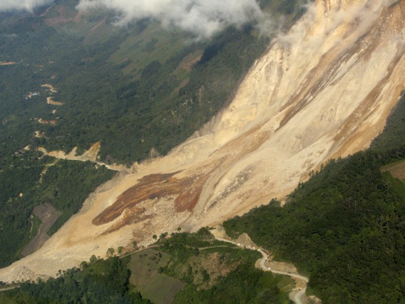
Leyte, Philippines, 2006A debris avalanche in 2006 caused over 1,100 fatalities on Leyte Island, central Philippines. At 10:30 a.m. on February 17, 2006, a complex rockslide/debris avalanche occurred on Leyte Island in the mountainous region of the Central Philippines (Fig. L10a). The 450 m-high hill behind Guinsaugon village consisted of fractured and sheared volcanic and sedimentary rocks along a major tectonic fault zone. About 4 days after a long period of heavy rain, during a particularly intense La Niña season, 15 million cubic meters of the hillside slid rapidly downhill. The debris flow completely engulfed Guinsaugon (Fig. L10b), causing over 1,100 fatalities, including 245 children who were in school. The foot of the rockslide/debris flow ran out by almost 4,000 m on a slope angle of about 12o. It is thought that when the debris flow reached flooded paddy fields in the valley, the additional water from the fields was incorporated into its base, enhancing its ability to flow and spread rapidly.
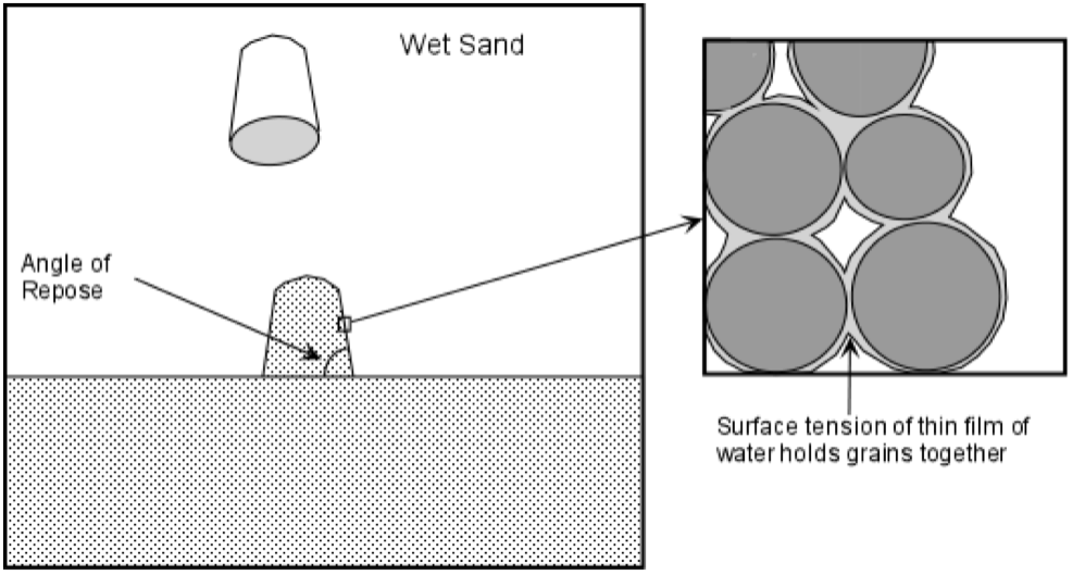
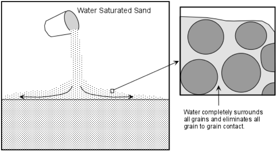
Landslides In Sands And ClaysDry sands have low cohesive strength and cannot build cliffs. Clays have more strength, but both materials will flow when saturated with water. Rocks become weathered by water and wind into sands and clays, which have a cohesive strength, but not as much as the original unweathered rock. Clay minerals have a flat, tabular shape and can better stick together than rounded sand grains. Frictional resistance to movement gives each of these loose materials additional strength when they are dry (Fig. L11a), but friction is easily overcome by gravity on very steep slopes. A small amount of water seepage into the spaces between grains creates a thin film of water around the grains. The surface tension of the water film increases the overall cohesive strength of the material (Fig. L11b). However, too much water pushes grains apart and drastically reduces the overall strength (Fig. L11c). The more water the material has in its spaces, the lower its strength. With enough water, or when vibrated, such as by an earthquake, gravity will completely overcome the combined cohesive and frictional strengths of loose materials, and a landslide results.
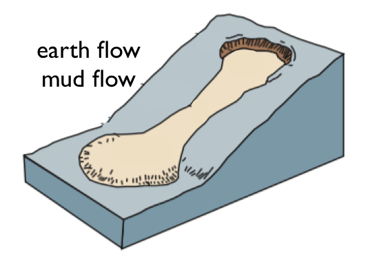
MudflowsMudflows contain more than 50% sand-sized or smaller particles. They can set like concrete. Like debris flows, a mud flow (also known as an earth flow) moves very rapidly down hill as a single, flowing mass (Fig. L12a), and the terms are often used interchangeably in the media. The main difference among the different types of flow is that the predominant particles in a mud flow are sandsized or finer (2 mm or less), and the material spreads out into a broad zone, even on very low slope angles, at the foot of the slide. Mudflows can move at speeds up to 50 km per hour. The smaller the particles in the flow and the more water it contains, the farther and faster it will travel. Where several mudflows are generated at the same time, such as by an earthquake, they can coalesce downstream into one very large flow that can completely overwhelm towns and villages. However, as soon as the mudflow stops, the material sets like concrete (Fig. L12b), making rescue efforts extremely difficult.
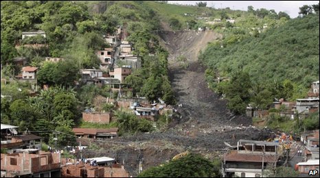
Saturated Soils: Landslides In Brazil, 2010Exceptionally heavy rain caused dozens of landslides near Rio De Janeiro, Brazil, in 2010. In the early months of 2010, heavy rain soaked the hillsides in Morro da Carioca, near Rio de Janeiro, Brazil, resulting in more than 80 landslides. More than 4,000 families were made homeless by the landslides in 2010, and at least another 10,000 houses were considered at risk. There were at least 60 fatalities in January of that year, including in the city of Angra dos Reis (Fig. L13a), where homes had been built directly onto very steep slopes. At least 12 people lost their lives. Also, on the nearby resort island of Ilha Grande, at least 26 people died in a landslide from the same storms. By April of 2010, the region had seen the heaviest rains in nearly 50 years, and on April 6 a landslide in the town of Niteroi resulted in 196 fatalities and the loss of 50 homes (Fig. L13b). The slide swept up part of a garbage landfill in its path, which made rescue efforts particularly challenging.
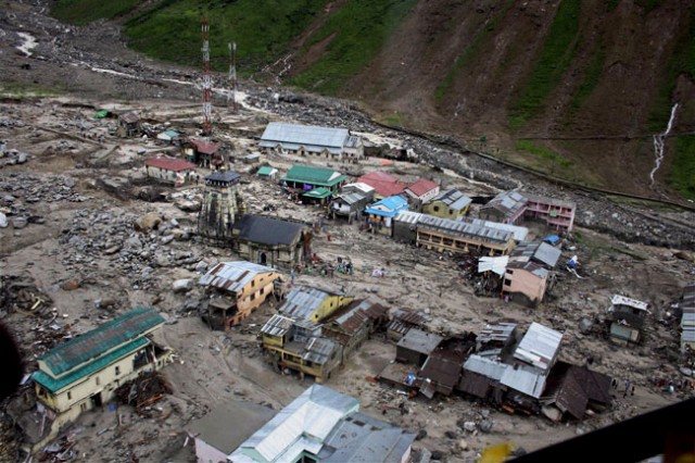
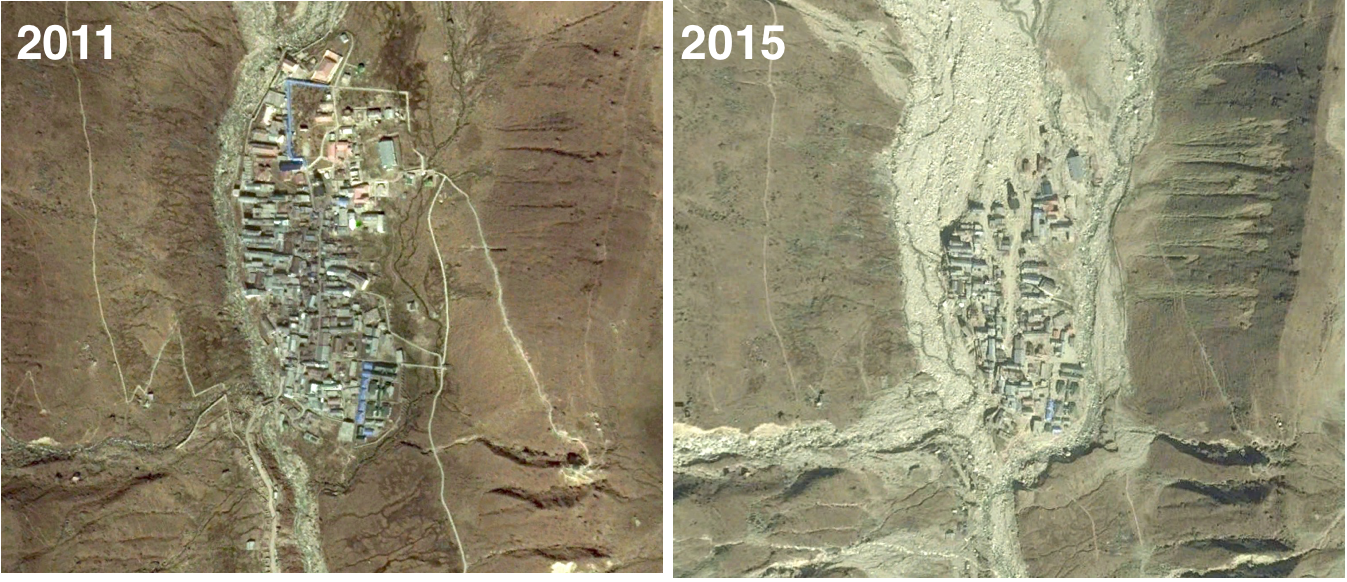
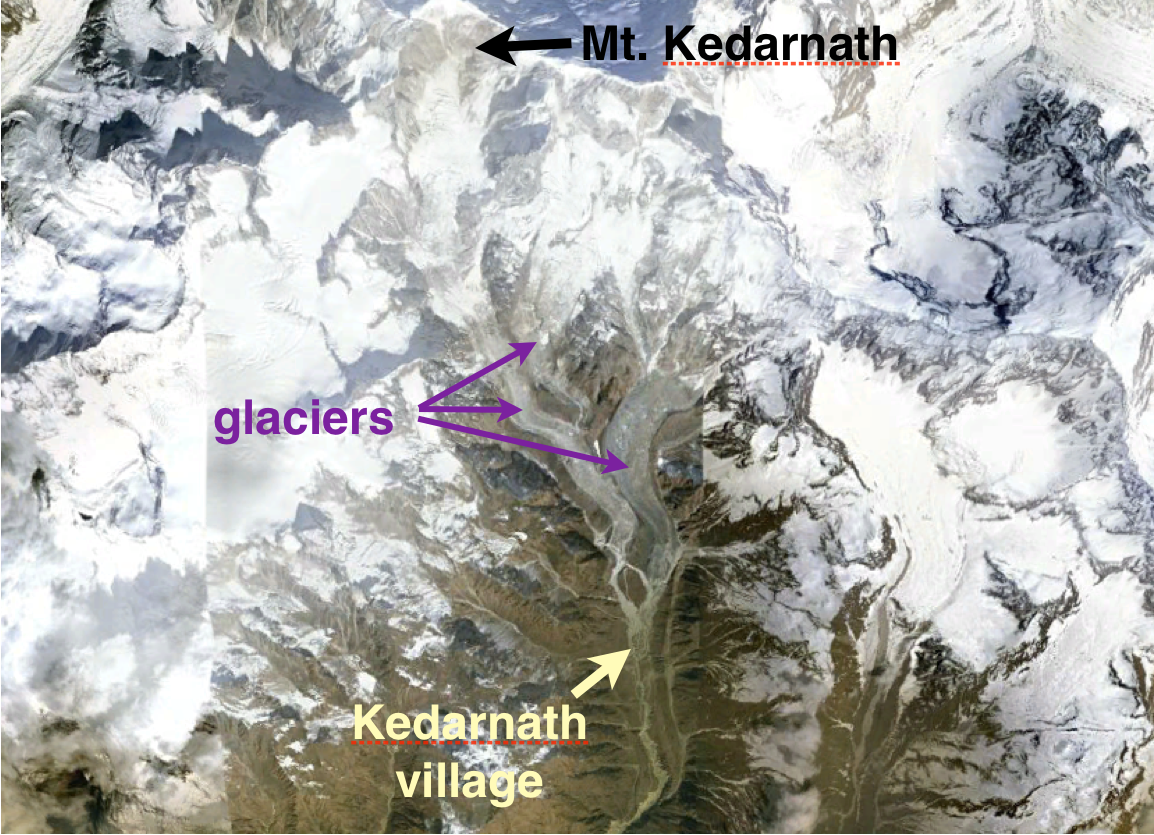
Monsoons And Debris FlowsNorthern India is vulnerable to landslides in the monsoon season, or at any time of intense rainfall. Villages in steep-sided valleys are at the most risk. Landslides are a regular occurrence during the monsoon season in the mountains of northern India. On July 30, 2014, in the state of Maharashtra, 151 people died in one landslide after torrential rain. In years when monsoons rains are heavier and last longer than usual, such as in 2010, there can be dozens of landslides. In that year, over 320 people in northern India — many of them children — were killed in more than 80 separate landslides. A multi-day downpour in June 2013, in the state of Uttarakhand, caused intense flooding and landslides, including a debris flow that completely destroyed the Hindu shrine village of Kedarnath (Figs. L14a and b). The village was located in a valley south of Mt. Kedarnath, beneath large glaciers (Fig. L14c), and one explanation for the disaster is that part of a glacier may have collapsed in the rain, triggering a downstream debris flow.
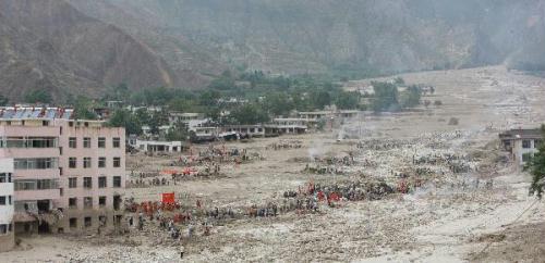
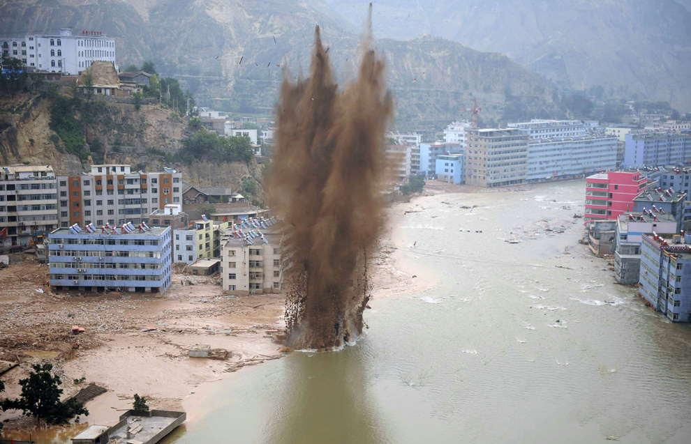
Zhouqu, China, August 2010The largest landslide of 2010 in terms of fatalities was the Zhouqu mudflow in Gansu, China on 8th August, which killed 1,765 people. One of the most devastating landslides in recent history occurred in the mountainous region of central China on August 8, 2010, when 1,765 people were listed as either dead or missing and thousands of homes were destroyed as a mudflow swept through the town of Zhouqu (Fig. L15a). The region had seen as many as 10 major landslides since the early 1800’s, and according to a 2006 report the landslide risks for the area had increased in recent years due to deforestation and mining activities. A previous landslide had recently dammed a stream, creating a temporary lake above Zhouqu town. Intense monsoon rains caused the lake level to rise until it broke through its natural dam wall, creating a slurry of mud as it raced through the town toward the Bailong River. Engineers had to blast away the debris in the river to avoid further flooding (Fig. L15b).
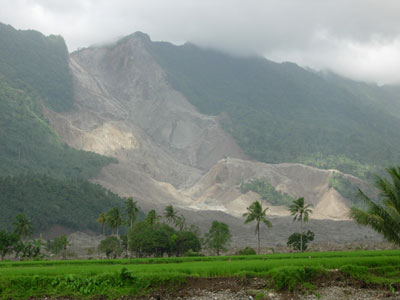
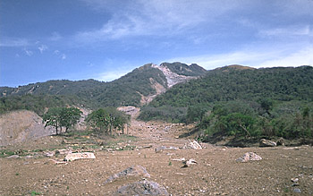
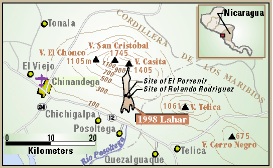
Hurricanes And LaharsHeavy rain from hurricanes triggers frequent landslides in Central America, including lahars from the slopes of long extinct volcanoes. Many people in the volcanic highlands of Central America farm on the flanks of volcanoes. Longextinct volcanoes often have very rich and fertile soils. Unfortunately, heavy rains from the regular hurricanes that pass over the region cause debris flows and lahars, which are a special type of debris flow composed entirely of loose volcanic material. Hurricane Mitch, in October 1998, devastated large parts of central America, causing hundreds of landslides. The most deadly was a debris slide/ lahar from the slopes of Casita Volcano in Nicaragua (Fig. L16a), which killed more than 2,000 in under 3 minutes as it engulfed the towns of El Porvenir and Rolando Rodriguez (Fig. L16b). The towns had been built, unknowingly, on a prehistoric lahar pathway. Radiocarbon dating showed that the valley had seen at least 3 major lahars in the past 8,300 years.
Deforestation And MudflowsMudflows after Hurricane Stan in 2005 killed over 1,000 people in Guatemala. Deforestation may have allowed the mudflows to travel greater distances. On October 5, 2005, up to 500 villagers in Panabaj, Guatemala, were killed when Hurricane Stan triggered a debris/lahar/mudflow from nearby Volcano Atitlán that engulfed their village (Fig. L17a). Guatemala is very prone to landslides and was listed in a 2009 United Nations report as 4th in the world in terms of risk of death from landslides. Deforestation between 1990 and 2005 removed 17% of Guatemala’s forests, and large trees in the path of a mudflow can help to slow down the flow and restrict the spreading at the toe (Fig. L17b). Guatemala was the hardest hit by Hurricane Stan, with more than 1,000 fatalities from mudslides. The loose volcanic sands on the slopes of its volcanoes are interlayered with clay soils that prevent water percolation. In heavy rain, water collects above the buried clay layers, reducing the earth’s cohesion and frictional resistance to sliding.
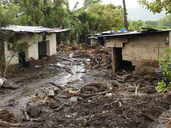
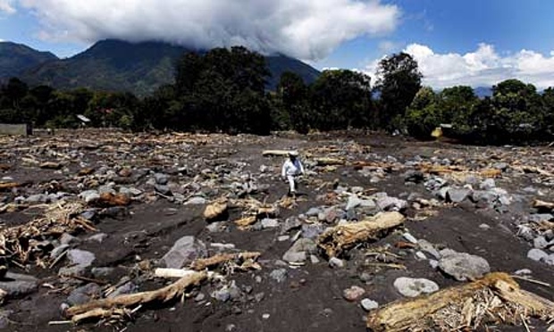
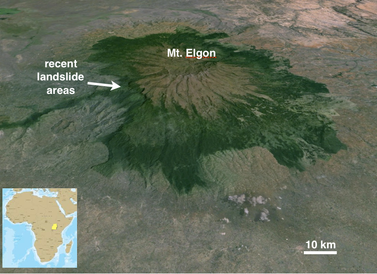
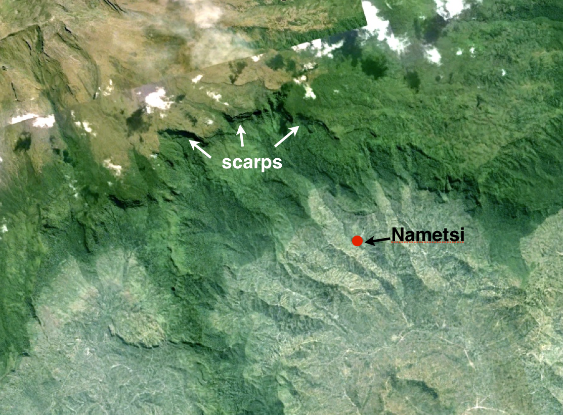
Deforestation In Bududa District, UgandaSince 2007, when deforestation was enhanced, the coffee-producing region of Bududa, Uganda, has seen several deadly landslides after heavy rains. On March 1, 2010, heavy rain induced landslides that buried at least 360 people on the slopes of Mt. Elgon, a 4,321 m-high extinct volcano in the Bududa district of Uganda (Fig. L18a). Three villages were engulfed, the worst effected being Nametsi, where 85 homes were destroyed. Survivors were relocated, but they complained of inadequate shelter, food, and water in their new settlement and also insufficient land to restart their farms, and many chose to return to their landslide-prone homes. Another landslide in Bududa district swept through four villages on June 26, 2012, after two days of heavy rainfall (Fig. L18b). Although the number of fatalities was relatively modest, 15 houses were buried and 448 people remained in high risk areas. Again on August 10, 2013, after 3 days of heavy rainfall and hailstorms, multiple mudslides and floods engulfed 5 villages in Bududa district. This time more than 3,000 people were displaced. This mountainous region of Uganda, known for its fertile volcanic soil and coffee production, has seen enhanced deforestation since 2007. Tree roots help to stabilize the thick soil on steep slopes. Although several ancient scarp slopes are visible on the satellite image in Figure L18a, local authorities claim that landslide incidence has increased markedly since the deforestation rate escalated.
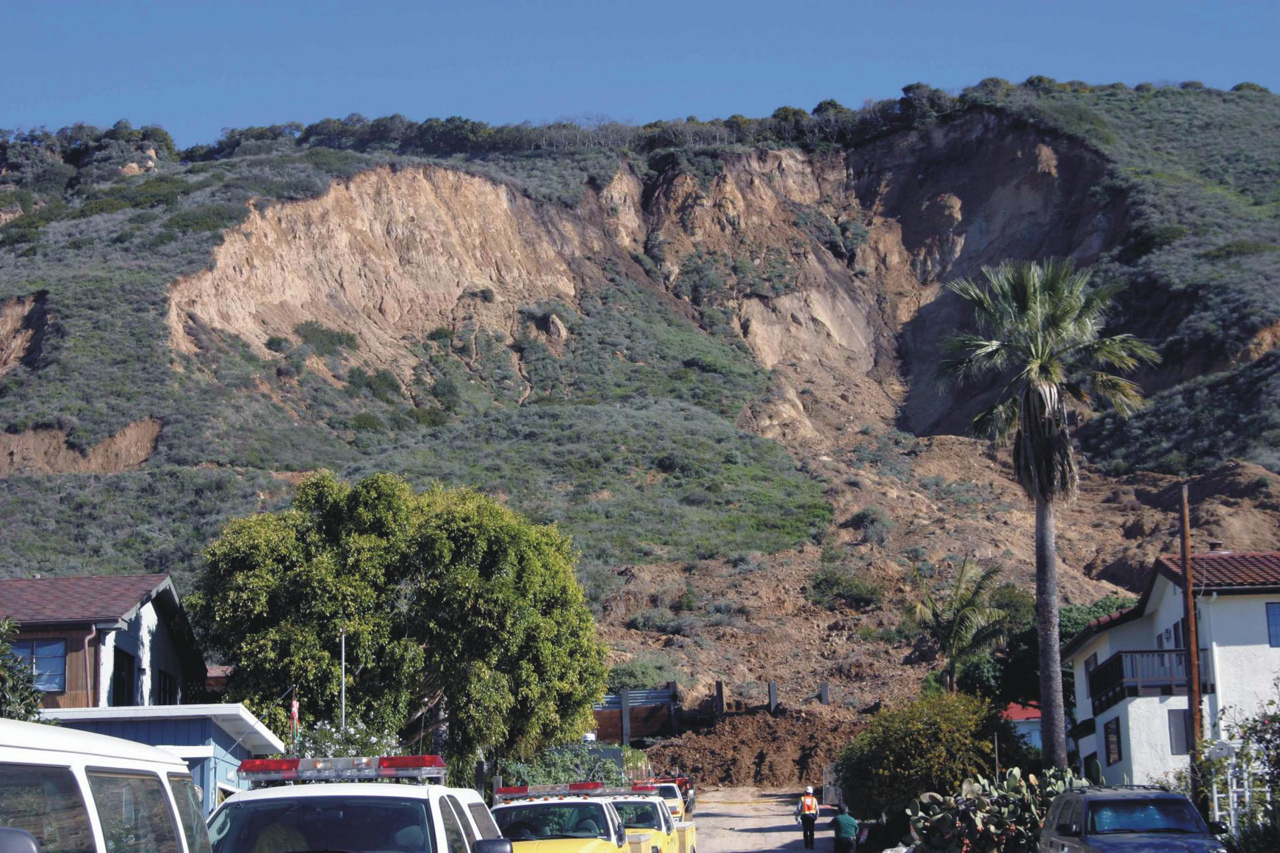
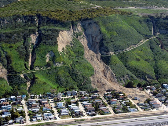
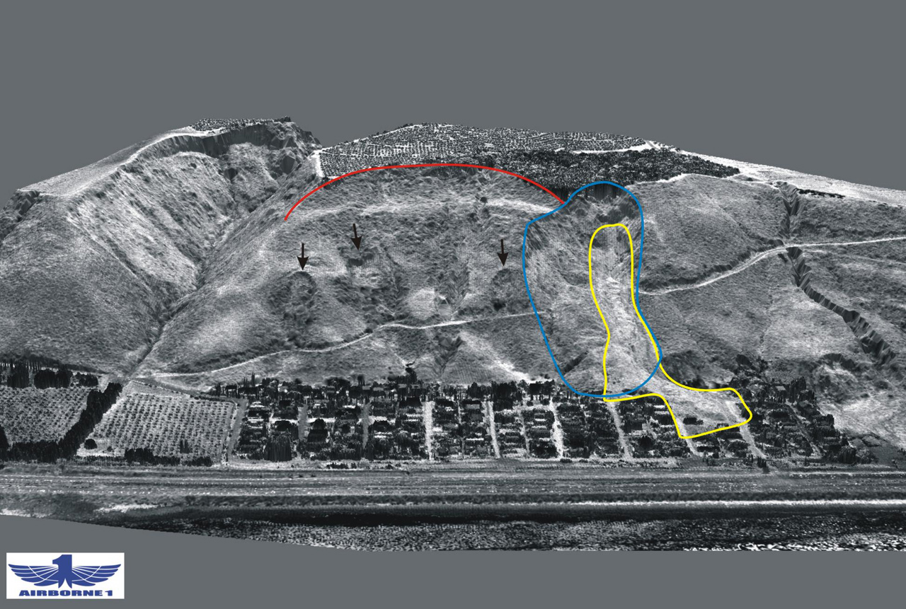
Coastal CaliforniaStrong storms such as El Niño events make coastal California vulnerable to landslides. Annual highway maintenance costs are over $20 million. Southern California is known for its dry climate, but as the saying goes: “when it rains, it pours.” In 2005, a strong El Niño season brought torrential rains to coastal California and caused numerous landslides. One of the most damaging was on January 10 at La Conchita (Fig. L19a), where the sandy cliffs collapsed in a rotational slump, killing 10 people, engulfing 13 homes, and damaging 23 others. The cliffs had slumped previously in March 1995, destroying 9 houses (Fig. L19b). The 2005 slump slid on a saturated base layer, remobilizing about 15% of relatively dry and stiff 1995 debris. Landslides along this stretch of California’s coast, which includes the Southern Pacific rail line as well as US Route 1, are a common occurrence. Annual highway maintenance costs alone average at least $20 million, and in the winter of 1979-1980 they were well over $1.1 billion.
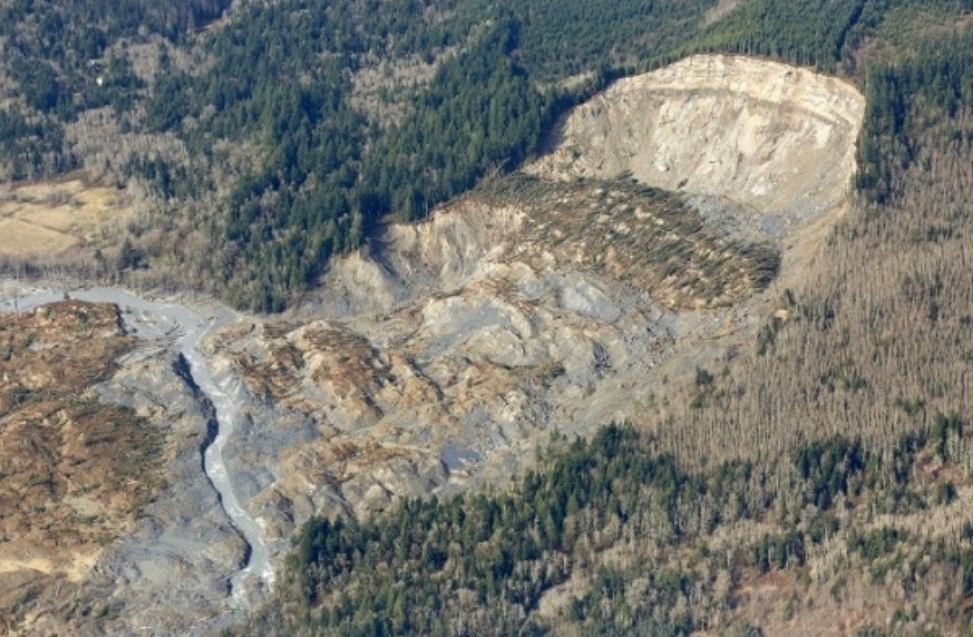
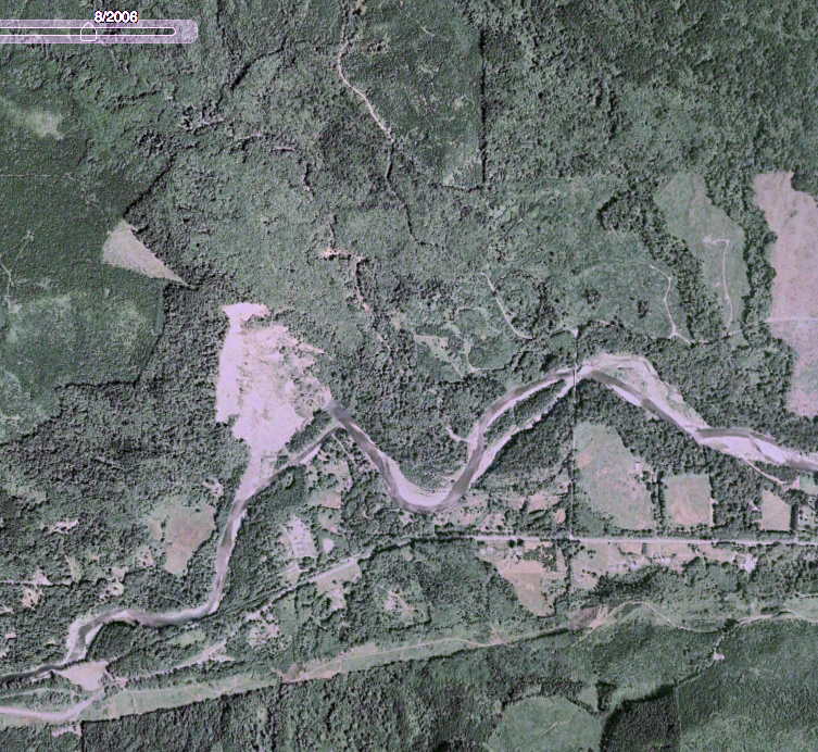
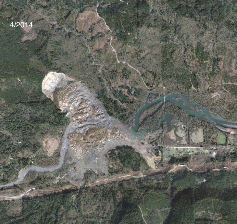
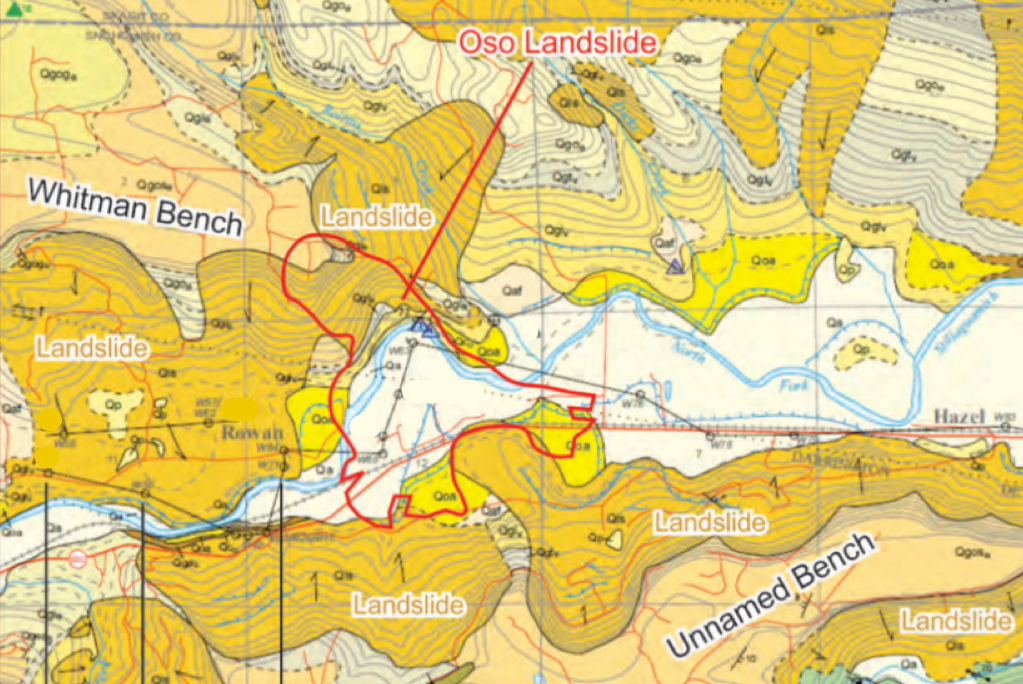
Remobilized Landslides: Oso, Washington, U.S.A., March 22, 2014Ancient scarps on mountainsides often mean that the slope beneath remains unstable. Many landslides remobilize more than once. On March 22, 2014, the hillside opposite the small settlement of Steelhead Haven, near Oso, Washington, collapsed in a rotational slump (Fig. L20a). Forty three people died, 10 more were injured and damages ran to over $50 million. The landslide, now referred to as the Oso slide, remobilized debris from previous landslides that were known to have moved many times,most recently in 2006 (Fig. L20b). Geological mapping of the Stillaguamish River valley shows that most of its hillsides are composed of debris (Fig. L20c) from landslides that occurred over the past 6,000 years. The research also showed that large landslides like the Oso slide in 2014 may occur in this region as often as every 400 to 1,500 years, with smaller ones at least every couple of decades.
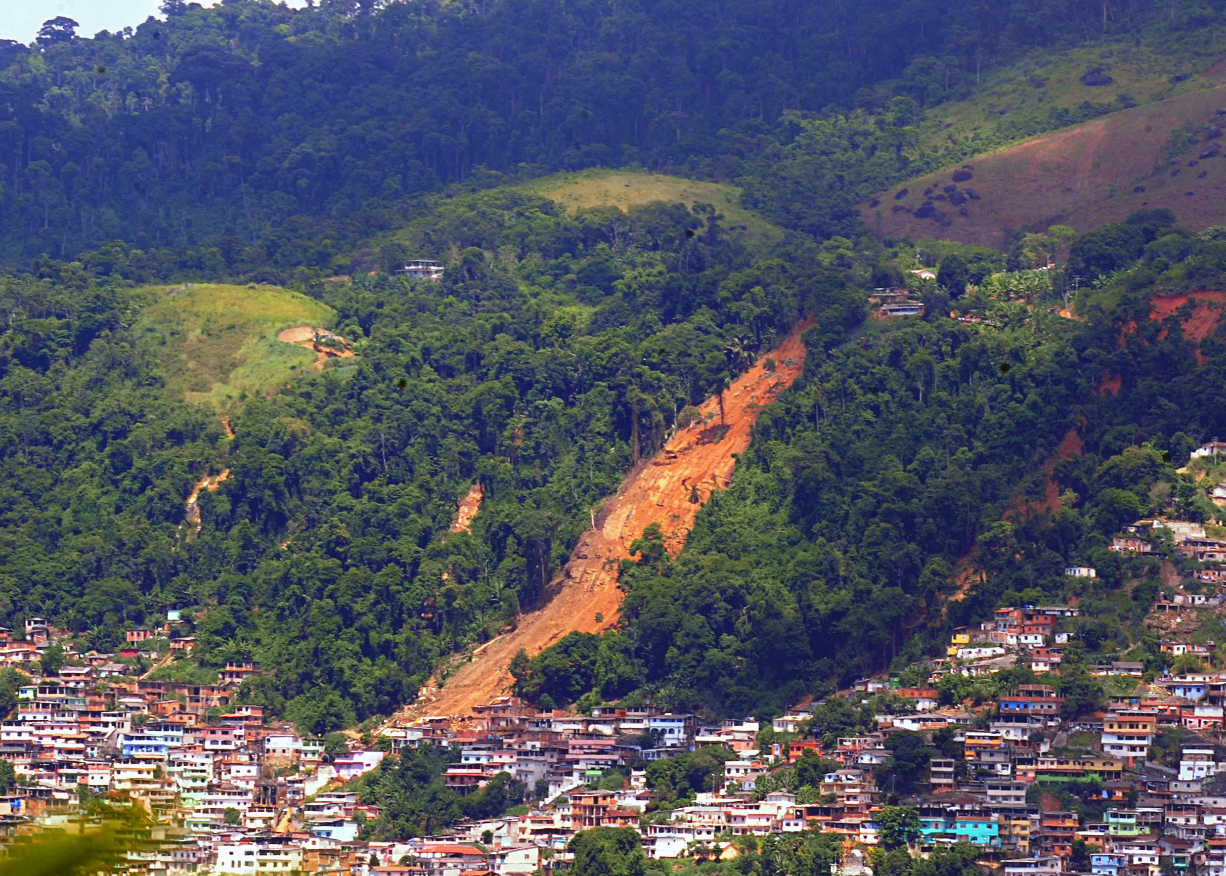
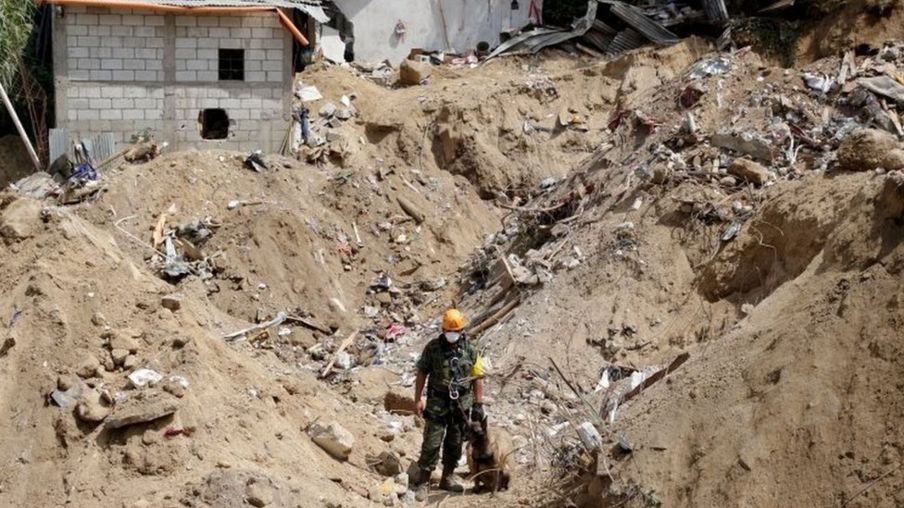
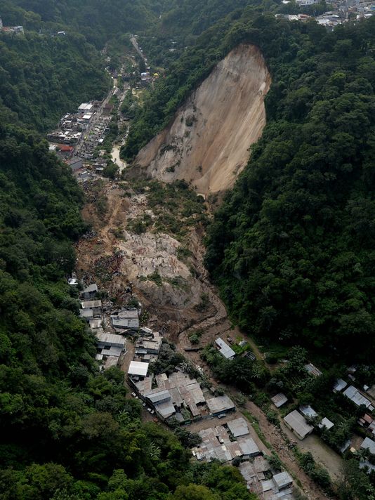
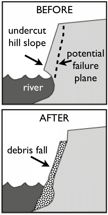
Slope Undercutting: Guatemala City, October 2015Undercutting of a steep hillside by a small river played a major role in a devastating debris fall and debris flow in Guatemala. Heavy rain over several days triggered a debris fall on October 1, 2015, in Santa Catarina Pinula, near Guatemala City. The saturated debris turned into a mudflow at the foot of the fall (Fig. L21a). The homes in the town were constructed at the base of a 100 m-high hill that was thought to be stable. However, the Pinula River, which runs through the valley, had gradually undercut the hill slope at its base (Fig. L21b), making the slope susceptible to collapse when saturated with rainwater. More than 280 residents died and at least 120 homes were destroyed by the debris and mudflow. The Guatemala National Disaster Reduction Commission (CONRED) said warnings were issued in 2009 and 2014, that the slope was potentially unstable due to river erosion at its base, but they were unfortunately ignored.
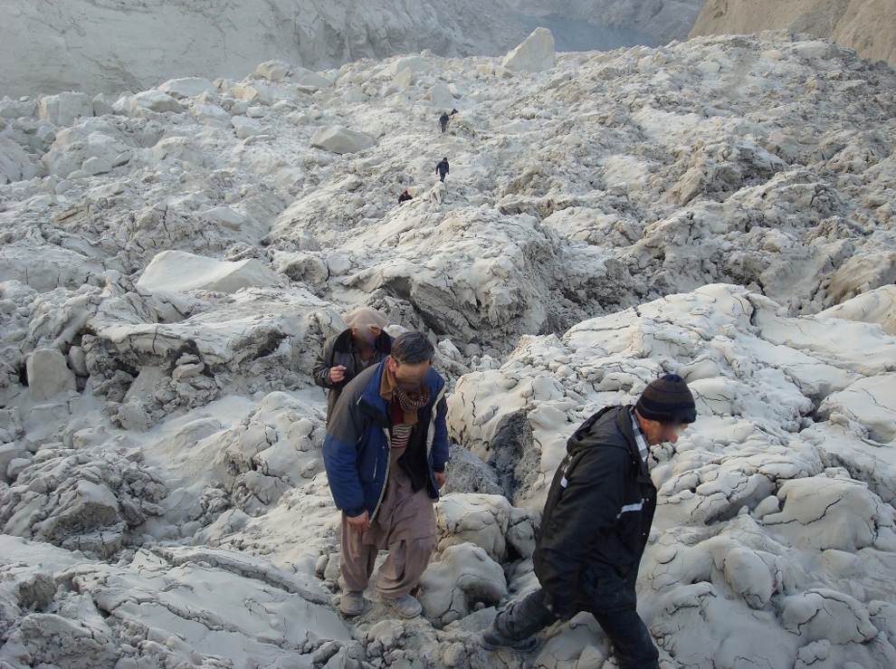
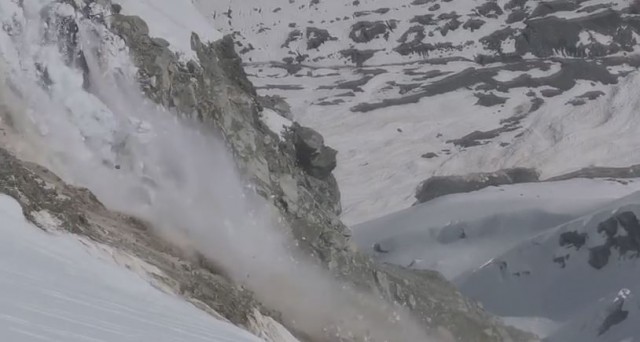
Rock/Ice AvalanchesIce avalanches commonly collect debris during the landslide, creating a complex and devastating rock/ice flow that can travel extremely quickly. Avalanches of snow and ice are frequent occurrences in snow-capped mountains and are a known danger for skiers and mountaineers. However, when the falling ice also takes with it a quantity of rock, the mixture becomes deadly and can travel at very high speed for long distances down valley, often collecting more debris and ice along the way (Fig. L22a). Even though the rock/ice mass starts as a dry mixture, it flows as fast and as far as a debris flow slurry. Friction among the falling ice and debris pieces, within and at the base of the flow, heat and melt the ice to create thin films of water around the blocks – in the same way as an ice skater travels over an ice rink. Between the flow and its base, friction is effectively reduced to zero. As more of the ice melts, the flow becomes a true slurry that can travel for tens of kilometers (Fig. L22b).
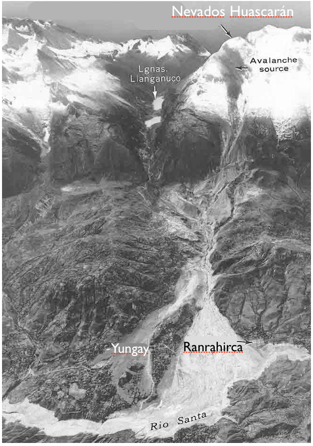
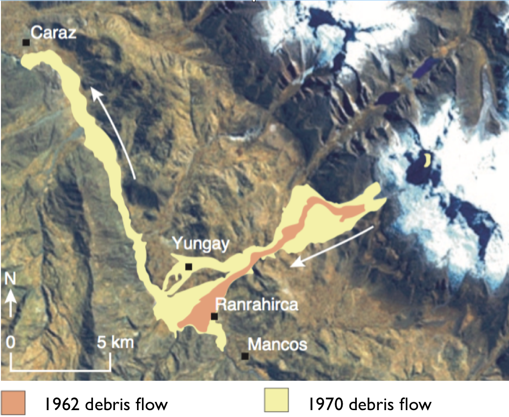
Nevados Huascarán, PeruTwo major rock/ice avalanches, in 1962 and in 1970, devastated towns in the mountains of Peru. The Andes are a chain of mostly volcanic mountains that formed as the result of the Nazca Oceanic Plate’s subduction beneath the South American Plate. People who live in Peru and Chile must cope with the many landslides that result from ground shaking during strong earthquakes. On May 31, 1970, ground shaking caused by a MW7.8 earthquake off the coast of Peru triggered a rock/ice avalanche from Nevados Huascarán, in Peru’s Cordillera Blanca. The landslide’s estimated volume was between 50 and 100 million m3. It swept down the valley at up to 280 km per hour, completely destroying the town of Yungay and causing over 18,000 fatalities (Fig. L23a). A similar rock/ice avalanche from Mt. Huascarán in January 1962, that began with the fall of a hanging glacier, had devastated towns in the same valley, causing more than 4,000 fatalities, mainly in the town of Ranrahirca (Fig. L23b).
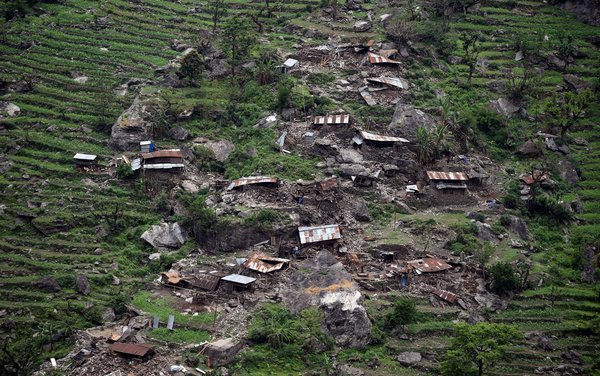
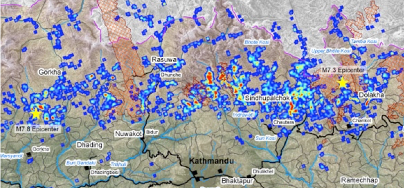
Earthquake Triggers, NepalLandslides triggered by ground shaking were responsible for many of the fatalities from the Nepal earthquakes of 2015. Although an individual landslide is confined to a localized area, casualties on a large scale result where the population density is high and many landslides occur at the same time, as in the Nepal earthquakes of April and May, 2015 (Fig. L24a). The intense shaking from the MW7.8 and MW7.3 earthquakes caused thousands of landslides, which contributed to one third of the estimated total 3,300 to 8,000 fatalities. The landslides were concentrated along the southern side of the Himalayan mountains, which is also where the population density is highest (Fig. L24b). As well as triggering debris slides, the shaking opened new cracks at the surface, which allows water access to the loosely consolidated debris remaining on the steep slopes. The risk of landslides in the region is therefore expected to remain high for at least the following 4 to 5 years.
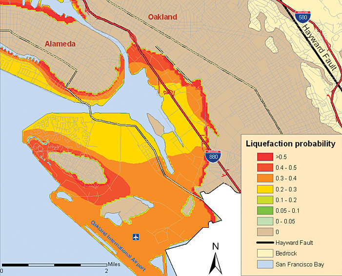
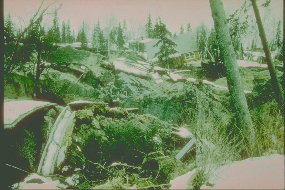
Liquefaction LandslidesSaturated sands and clay-rich soils can liquefy – that is, flow as a liquid – when vibrated by an earthquake or even by heavy machinery. Quicksand is notoriously treacherous. Ground that seemed to be perfectly firm for walking can suddenly turn into a liquid. The phenomenon is called liquefaction. A fully saturated sand, with all the spaces between sand grains completely filled with water, can be quite stable if undisturbed. However, if shaken or disturbed, the grains settle into a more compact configuration, the water rises to the surface, and all cohesive strength is lost. Saturated ground often liquefies in earthquakes (Fig. L25a). Liquefaction landslides caused most of the destruction in Anchorage, Alaska, during a MW9.2 earthquake on March 28, 1964 (Fig. L25b). The city is built on clay- and sand-rich glacial sediments that are stable unless shaken, when they turn into quicksand. The liquefaction landslides destroyed 75 homes, a school, and parts of Anchorage’s main business district.
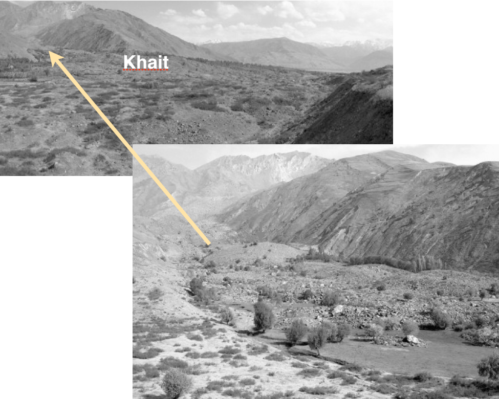
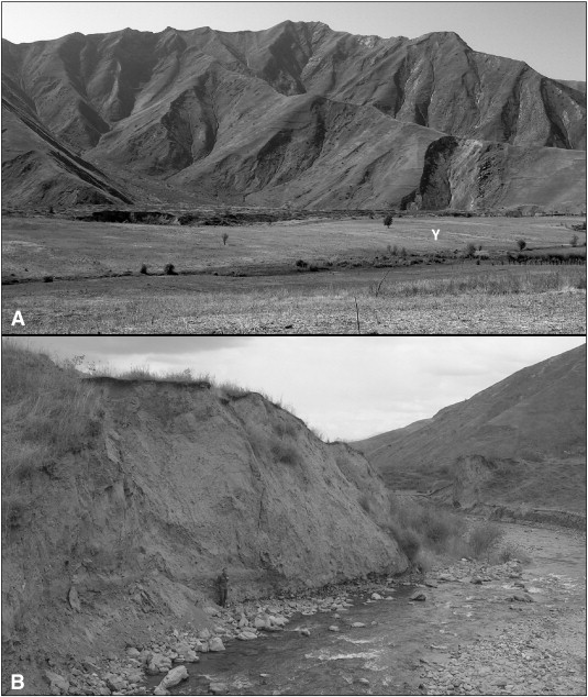
Liquefaction Of LoessThick loess deposits are found in many parts of the world. Although loess is very stable when dry, when saturated it liquefies extremely easily and flows great distances on very gentle slopes. A number of regions in the world, including large areas of western China, have thick deposits of loess – a wind-blown dust of very fine, angular particles that is strong and stable when dry, but very prone to liquefaction when saturated. In the normally arid Tien Shan mountains of Tajikistan, an earthquake of MW7.4 on July 10, 1949 in rainy weather triggered hundreds of landslides that included material from ancient loess deposits. In the Obi-Khaus-Dara River valley, several hundred people were killed when a combined rockslide/loess flow covered the town of Khait and Khisorak village (Fig. L26a). In the Yasman valley, several loess flows from tributary valleys coalesced into one huge flow, 10 m-thick (Fig. L26b), that travelled for 20 km on a slope of only 2° engulfing 20 villages Approximately 4,000 people were killed in Yasman valley.
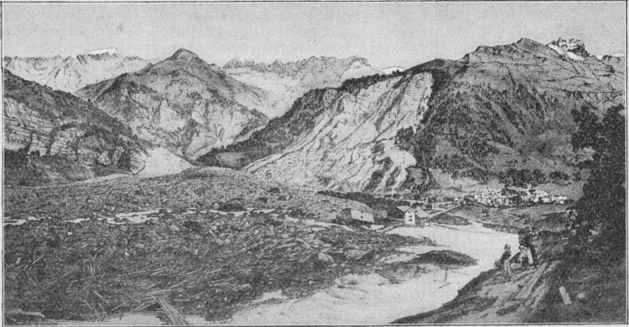
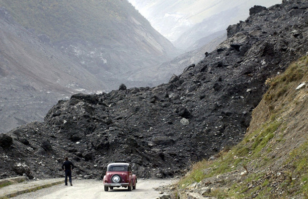
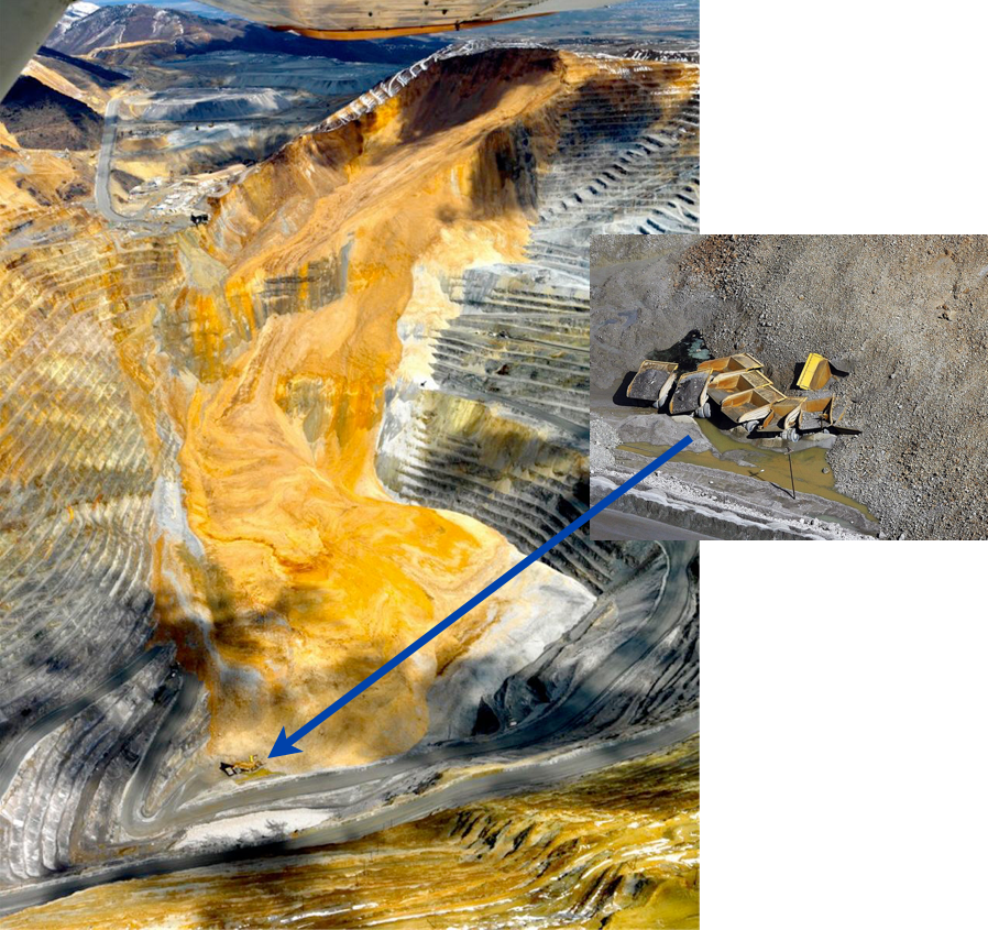
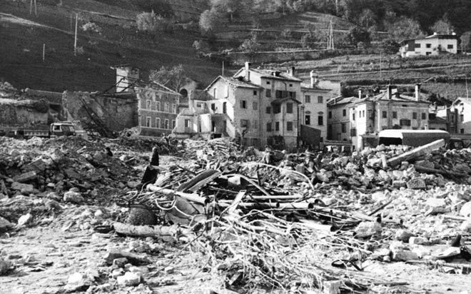
Human-Induced LandslidesMany historic landslides have been triggered inadvertently by engineering activities. The consequences can be far-reaching. Humans have geo-engineered their surroundings since time immemorial. Many small and large landslides have been triggered by engineering projects such as dam-building, road and railway cuts, re-engineering of rivers, open-pit mining, and there major construction projects (Fig. L27a). One of the worst engineering-related landslides in the past century occurred in the steep-sided Vajont River valley in Italy, on October 9, 1963. Construction of the Vajont Dam had been completed, but during the initial filling stage a large landslide fell into the lake behind the dam, generating a 250 m-high wave that overtopped the dam wall and swept down the valley. Several villages and towns were destroyed and over 1,900 people were killed (Fig. L27b). Previous reports warning that the mountain slopes behind the dam were unstable had been ignored.
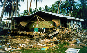
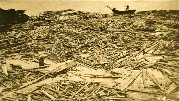
Submarine LandslidesLarge underwater landslides, usually triggered by earthquakes, have caused destructive tsunamis. Some of the most devastating tsunamis have been generated by large submarine slumps that were triggered by earthquakes in coastal regions. In Papua New Guinea on July 17, 1998, a MW 7.0 earthquake caused an underwater landslide offshore from Sissano Lagoon. The displacement of water by the landslide caused a 10 to 15 m-high tsunami (see Tsunami Chapter) that killed over 2,000 people in the town of Aitape and nearby coastal villages. Three schools were among the hundreds of destroyed buildings (Fig. L28a). Another example occurred on November 18, 1929, when a MW 7.2 earthquake off the Grand Banks, Newfoundland, Canada, triggered a submarine landslide that in turn generated a tsunami. The slumping sediments destroyed several kilometers of transatlantic telegraph cables, and the tsunami caused 29 fatalities and over $400,000 in damages (Fig. L28b).
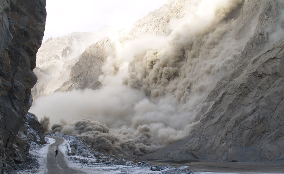
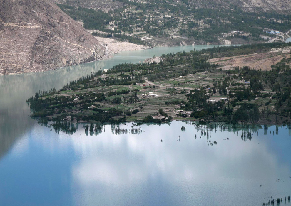
Attabad Lake, Pakistan, 2010Landslides often block rivers and create lakes behind the debris fall. Rising water levels in the new lake can be devastating to villagers upstream. In January 2010, a large landslide near Attabad village in the Gojal Valley of northern Pakistan killed 20 people and, together with secondary landslides (Fig. L29a), it blocked the flow of the Hunza River for several months. Over 6,000 people were displaced. The landslide created Lake Attabad behind the debris. The lake initially was less of a concern than the blockage of the main Karakorum Highway, which prevented villagers upstream from obtaining necessary supplies (see also Fig. L12b). However, as the weeks and months passed, the lake behind the debris dam began to fill the valley Over several months, villages and farms were slowly inundated (Fig. L29b) and 19 km of the Karakoram Highway became submerged. The diverted highway, with 5 new tunnels, is now being completed in a cooperative effort between Pakistan and China at a cost of $275 million.
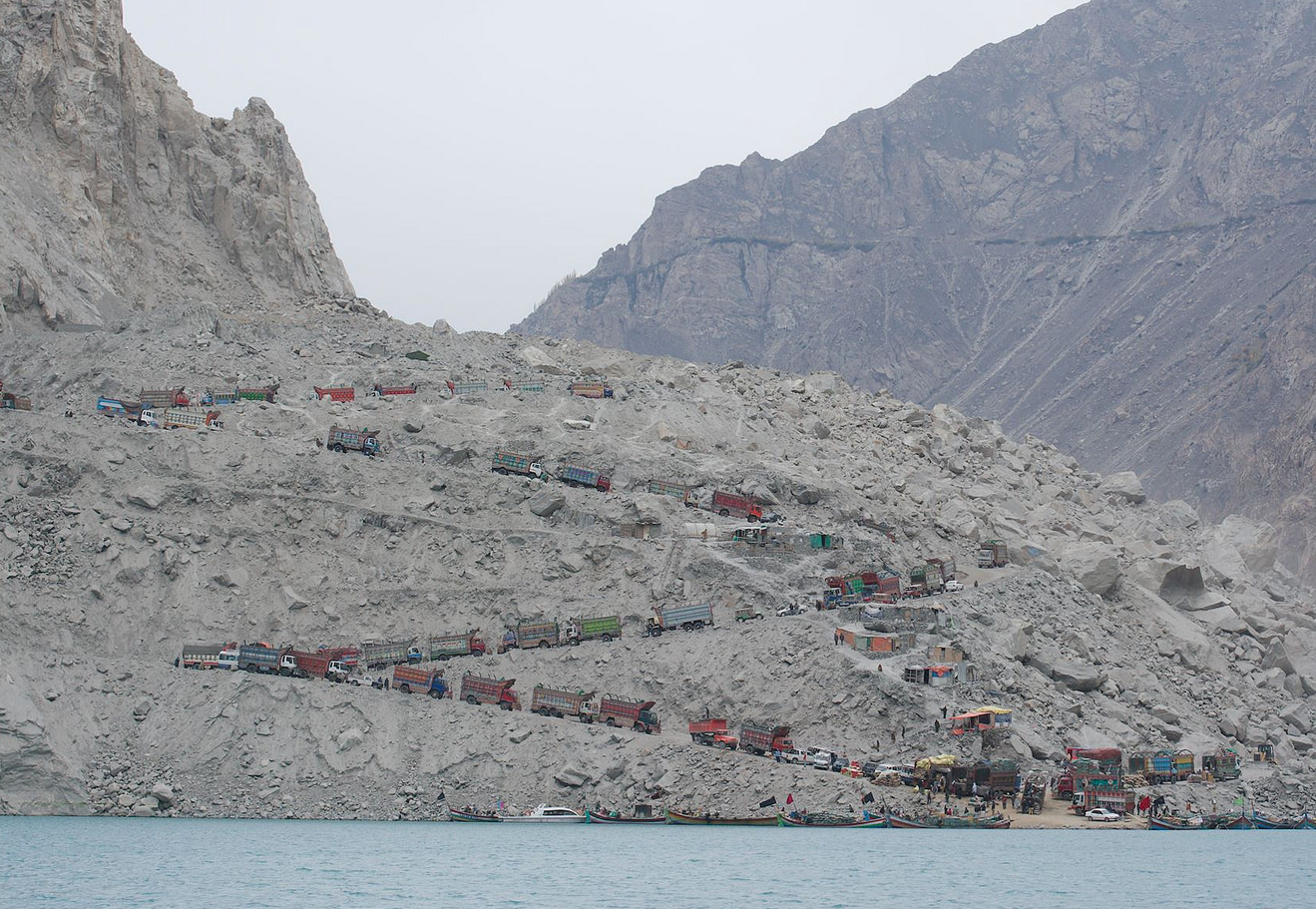
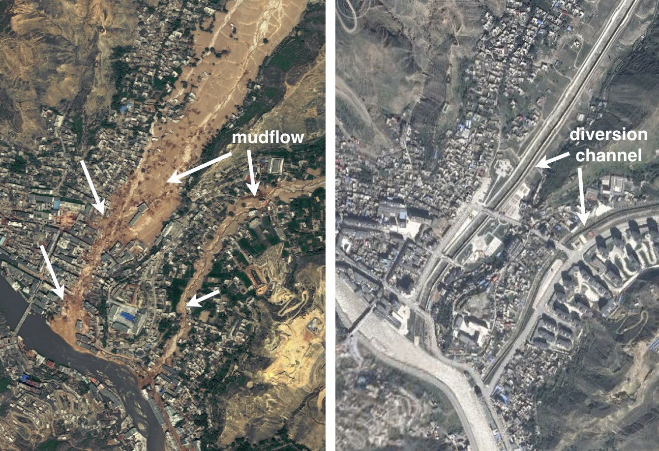
RecoveryRecovery after a landslide is possible, but costly. Recovery after a major landslide is expensive. Entire villages and towns may need to be moved to new locations. Homes, transportation routes, bridges, pipelines, schools, businesses, and other infrastructure will need to be rebuilt. Agricultural land is often slow to recover, especially in normally arid regions or where fertile topsoil has been buried by rocky debris. Reconstruction of highways in mountainous terrains is especially challenging. Five new tunnels, 2 new bridges and 78 new culverts had to be constructed along a 7 km stretch of the Karakoram Highway after a 2010 landslide took out the road and blocked the Hunza River in Pakistan, creating Attabad Lake (Fig. L30a). In urban areas, where a landslide risk remains and the population density is too high to be moved easily, construction of expensive, but necessary, diversion channels can help mitigate the effect of future mudflows (Fig. L30b).
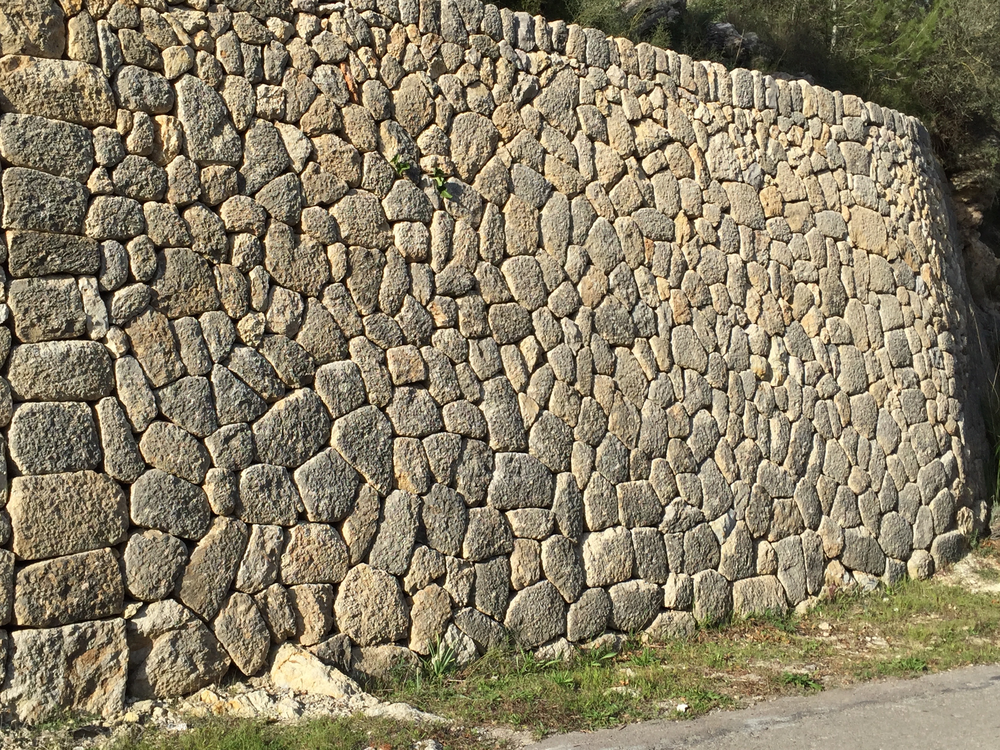
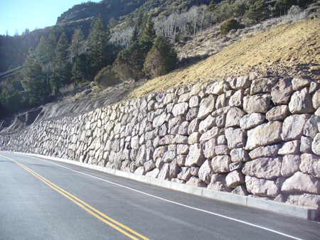
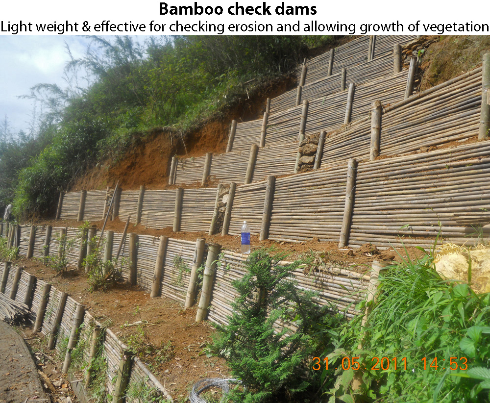
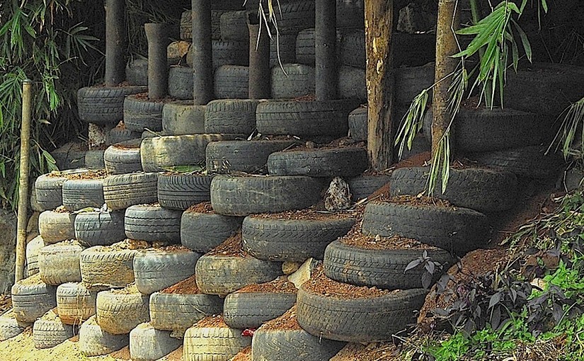
Slope StabilizationSteep hill slopes can be stabilized by terraces held in place by walls of local materials, which can help direct surface water away from unstable ground. The terracing of hill slopes has been a practice around the world for centuries (Fig. L31a). Terraces have two advantages: in dry climates, some water is retained in the soils behind the retaining walls; secondly, and of greater importance for unstable slopes in wetter climates, terraces force water to move across, rather than straight down the hill slope. This slows the downhill movement of water and reduces the likelihood of a debris flow. Where available, local stones are used for the terraces’ retaining walls. When correctly constructed, the walls require neither mortar nor cement (Fig. L31b). In countries that do not have readily available large stones, such as in parts of the southern Himalayas and the Caribbean, other locally available materials can be equally effective (Fig. L31c). Where feasible, it is even more effective to add material to the base of the slope behind retaining walls in order to reduce the overall slope of the hillside and its potential for sliding.
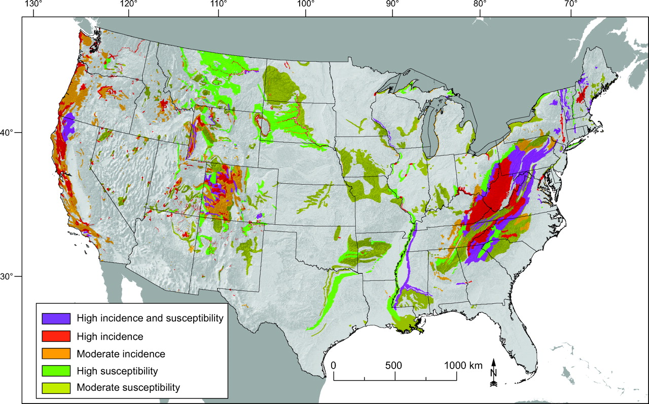
Landslide Risk AssessmentThe economic losses caused by landslides around the world each year are considerable, but mitigation, including mapping, monitoring, and prediction, leads to improved safety Any region in the world that has a combination of high relief and heavy rainfall is likely to experience frequent, often fatal, landslides. A 2004 report estimated the average annual cost of landslides in the U.S.A. alone as more than $3.5 billion. Slope failures are exacerbated by expensive modern infrastructure needs that require disturbing large amounts of earth. In Europe, North America, and other developed countries, the direct economic cost of landslides is far greater than in lessdeveloped countries, even though the average annual loss of life is much lower. Devastation from landslides can be reduced by effective risk assessment, mitigation, and disaster management. Most of the landslide-prone regions of the world now have landslide hazard maps to assist in planning for mitigation and recovery efforts (Fig. L32). By using and refining risk assessment protocols it is possible to avoid locating new large-scale constructions in the path of a potential slide. Unfortunately, people in densely populated, under-developed countries may have no option but to remain living in areas that have a high landslide risk. The region may not have the economic means to invest in mitigation efforts nor in large-scale relocation of its people. The direct economic loss of landslides for them is in the loss of family members, their homes and villages, and farm lands that represent decades of hard work.
Class Reading Listvan Westen, C., n.d., Introduction to landslides. Part 1: Types and Causes. pdf. van Westen, C., n.d., Landslides. Chapter 4 in Methodology Book, Caribbean Handbook of on Risk Management (CHARIM). html. |